Southeast Asia's classical empire of Angkor moved it's capital over the centuries several times. All of them were placed in the same area, means some kilometers north or east of nowadays Siem Reap in Cambodia. One of these capitals, and it was also the last and the best-known of Angkor's capitals, was Angkor Thom, what means 'big city' or 'big capital'. The famous Bayon was the state temple of Angkor Thom, placed right inmiddle of the four times three kilometers long, square-shaped areal.
The Face of Angkor
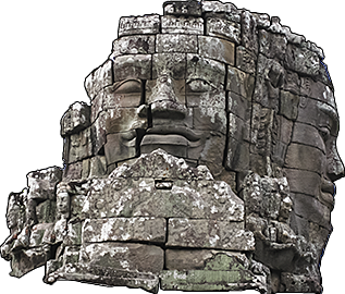
Angkor's mysterious smile. Presumably it's performed after Jayavarman VII's model, who was revered as a Bodhisattva. Image by Asienreisender, 2006
Angkor Thom wasn't the first of Angkors capitals on the site. A former capital, Yasodharapura, overlapped the site of Angkor Thom at the northwestern part. Two of the significant buildings from the Yasodharapura era were the former state temples Baphuon and Phimeanakas. The latter was then integrated into the new royal palace.
Angkor didn't end at the city walls of Angkor Thom. On the contrary, it stretched out for many more kilometers in all directions. At it's 'best times' it was populated by a million inhabitants. Considering that, one could call Angkor Thom a 'city in the city', or the royal quarter of Angkor, where the most representative buildings and constructions were concentrated.
By the way: in the epic computer game 'Civilization IV', Angkor Thom appears as a city of the Khmer empire (and Angkor Wat as one of the world wonders).
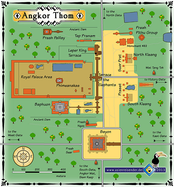
Map of Angkor Thom
A map of Angkor Thom's center with the Bayon, Baphuon, the Royal Palace area and the Terrace of the Elephants.
The State of the Park
Angkor Thom is part of the great Angkor Archaeological Park. And Angkor is big business. It's the only thing what makes Cambodia anyhow remarkable. Due to Angkor, some people worldwide have an association with Cambodia and visit the site. Without Angkor, Cambodia would be a completely forgotten country.
Restoration Work
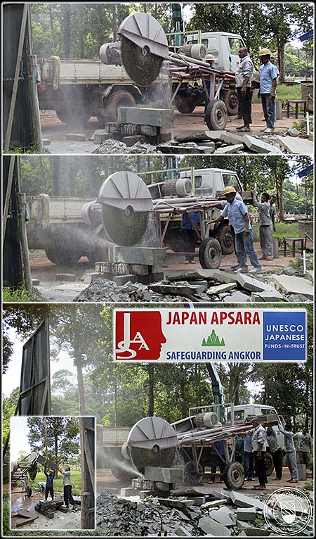
Cutting sandstone for restoration work in Angkor Thom. It's done by 'Japan Apsara'. Images and photocomposition by Asienreisender, 2015
Visiting Angkor Archaeological Park is not cheap. When I was here for the first time in 2006, a three-day ticket cost me 65 US$. Meanwhile (10/2015) it's down to 40 US$. But that's just the beginning. One has to pay for transport (by distance much more expensive than anywhere else in the whole country), accommodation and food at least. Siem Reap is meanwhile a very expensive place. Real estate prices went up rocketlike and the tenants have to let the visitors pay the price for it and the high rents. A large tourist industry offers many things for the consumers, and many scums happen here. Siem Reap, respectively the circle who owns it, got rich very fast by all the tourists.
According to estimations there is an annual income of 150 million US$ made by the park's entrance fees alone. It's sad to see how little of the money comes back to the site. In the last nine years I see practically no improvement in the infrastructure. All what has been done in the meantime was done by foreign organizations. The Apsara authority who administers the park and the Sokha Group who cashes the ticket fees did obviously the least they could for the site.
The roads are very bad. There are few, by no means enough road signs (as everywhere in Cambodia) in the park for the visitors orientation. There is far too much traffic in the park, and no public transport system. There are no explanation tables who give at least basic information about the sites, except the few who were put up by the foreign restorators. There are no safety measures taken for the visitors. When one has to climb the ruins, they usually miss a railing. Climbing over some parts one feels the stones are loose and move, what can easily cause an accident. There is so much more to do in restoration work and the money is there, but it's not going into the monuments. Many young Cambodians are around in the park, begging to tourists or selling them cheap crap. They could learn something useful, restoration work for example. But it's not done. The country's ruling class does not care at all for the People of Cambodia. Angkor is private property, and the management and the owners behind let the monuments, the very pride and symbol of the country, rather decline. They, the former communists, have no interest but to grow ever superricher and collect luxurious cars, villas and gulf courts for their pleasure.
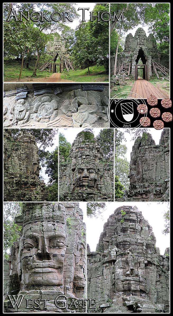
The West Gate is the least visited of the five gates of Angkor Thom. It's pretty instable and supported by wooden constructions at the bottom. The gopura is held together with a steel rope, an insufficient solution.
Sokha company, who runs Angkor Archeological Park, makes at least 60 million dollars a year with the entrace fees. Other estimations are up to 110 millions. However, they give little, if anything, back for restoration. There is much, much to do in the park, but it's all done by international organizations on foreign costs.
The causeway over the moat is berieved of it's demons who pull the two naga balustrades.
All images and photocomposition by Asienreisender, 9/10/2015
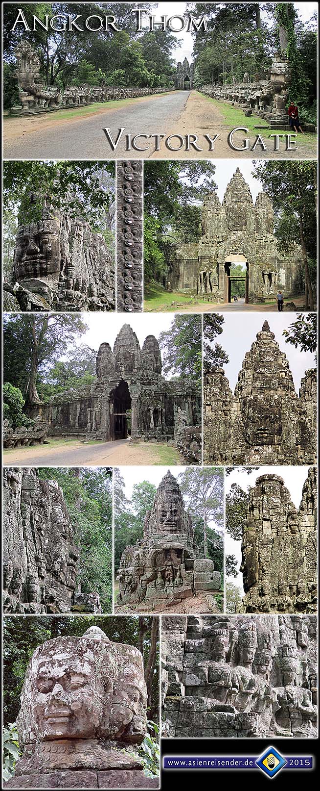
Victory Gate is in a much better shape than West Gate, but still looks poor. Most of the demons are beheaded. The road along here leads to Takeo and famous Ta Prohm. There is a lot of traffic here meanwhile, even at the bottom of the low season, in September.
The girl right is begging tourists for money. Unusually, she is alone, for Cambodian kids appear normally in groups. Not few kids are forced by their parents to beg, and if they bring not enough money home, there can be trouble. Child abuse is a frequent thing in Cambodia.
All images and photocomposition by Asienreisender, 9/10/2015
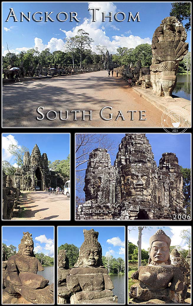
The South Gate is the by distance most visited gate of the five for it connects Angkor Thom with nearby Angkor Wat. Traffic is too much, often there are meanwhile jams on both sides of the gate.
The demons have been restorated and repeatedly again been stolen. Still, since this is the most representative gate of the former royal city, most restoration effort is concentrated on it.
All images and photocomposition by Asienreisender, 2006, 2015
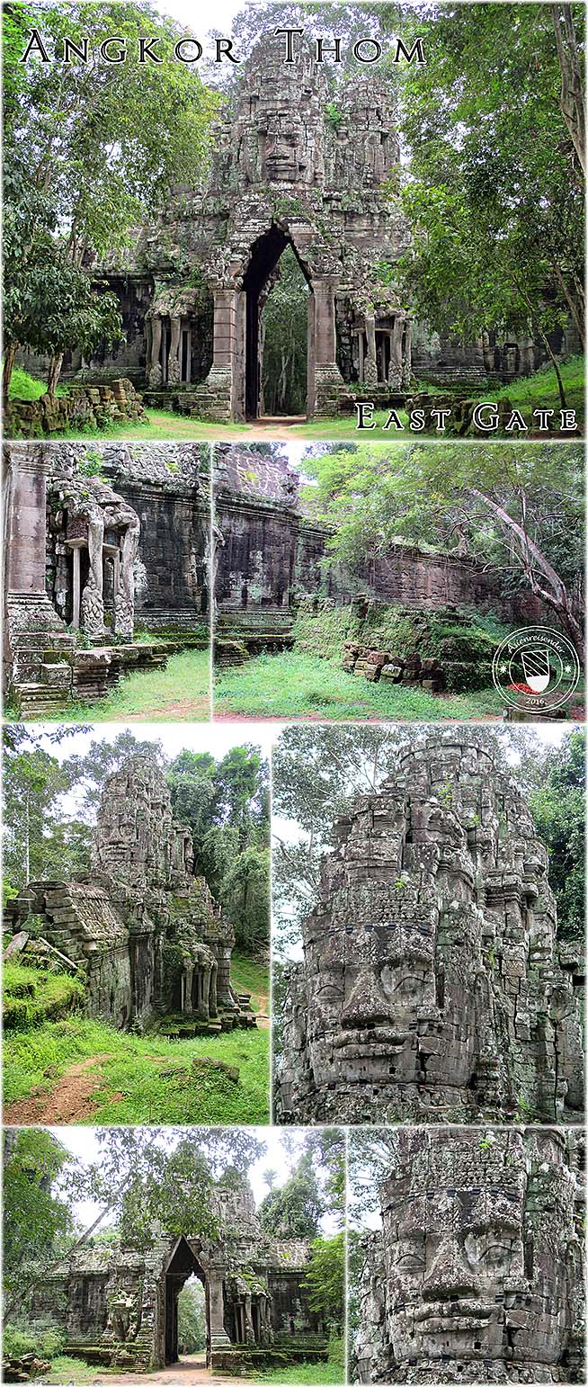
The east gate is, like the west gate, barely visited. It lies inmiddle of secondary forest. When leaving Angkor Thom through the east gate, the road get's worse and narrow, and finally shrinks into a common jungle path.
The gate seen from both sides, parts of the wall and the faces. Images and photocomposition by Asienreisender, 10/2015, 2016
For a closer look on the Gates of Angkor Thom click the chapters.
2.
Historical Background
The Cham Wars
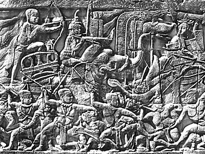
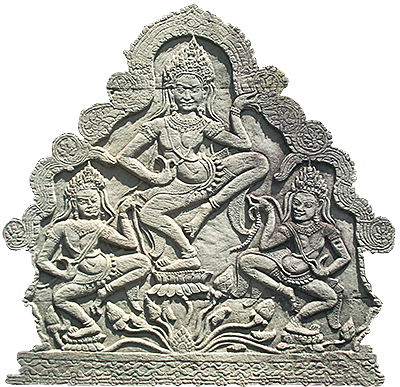
A relief depicting a battle scene between a Khmer and a Cham army. Interestingly, the warriors are scarcely dressed in the tropical heat; they might have rather believed in the magic of necklesses and amulets for prevention. Only one fighter who sits on the neck of the elephant is wearing a knightlike armor. The bowman behind him is probably a nobleman. Image by Asienreisender, 2006
Angkor's old rival, the Cham empire, what had it's center in what is nowadays south Vietnam, sent in 1177 CE a great navy upwards the Mekong River and the Tonle Sap Lake to target Angkor. In a great sea battle on the Tonle Sap Lake they defeated in a surprising strike the Angkorean forces, killed Angkor's king Tribhuvanadityavarman and gained control over Angkor. Though, there remained resistance against the Cham, led by a prince who later became king Jayavarman VII, one of the most significant Angkorean kings. Jayavarman organized troops and succeeded to drive the Champa out of Angkor, winning another naval battle on the Tonle Sap Lake. In the following years the Champa were repeatedly defeated and became even a tributary of Angkor, after their capital was sacked.
In the aftermath of the 'reliberation' of Angkor in 1181 CE, Jayavarman became the coronated new king of Angkor and ordered to build a new capital, which was Angkor Thom.
3.
Angkor Thom
The first half of the 13th century might mark the zenith of the Angkorean empire. The capital of Angkor with the new centerpiece Angkor Thom reached a size bigger than all the European cities of the time, including London, Paris and even Rome. One has to mention here (again) that Angkor was still much bigger than the inner core, Angkor Thom, which was reserved for the king, the aristocracy with the high priests, the new state temple (the Bayon) and for great representative events on the 'Victory Road' near the Terrace of the Elephants. Around this centerpiece, the mass of Angkor's population lived, the peasants, the craftsmen, more priests and the majority of the men who formed the army. Most of these people lived in the typical Southeast Asian shacks and stilt huts of the simple people, built of wood and bamboo, with grass or leaves forming the roofs. These buildings weren't sustainable and therefore disappeared traceless over the time, eaten up by the tropical nature.
However, at it's largest expansion, the capital inhabited up to a million people and was therefore the largest preindustrial city in world's history.
The City Wall
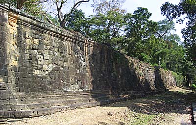
Angkor Thom's city wall. It's still widely intact. One can walk on top of it and I guess one could walk all around Angkor Thom. Image by Asienreisender, 2006
Representative Angkor Thom therefore was (and is) an area of three kilometers in both length and width. It's four sides are aligned to the points of the compass. It was surrounded by an eight meters high wall made of laterite stone, of which was outside a 100 meters wide water trench dug out. At the inner side of the wall soil was accumulated to enforce the walls and enable soldiers from inside to reach the top of the walls. It's still possible to climb up to the top of the wall and walk along on it.
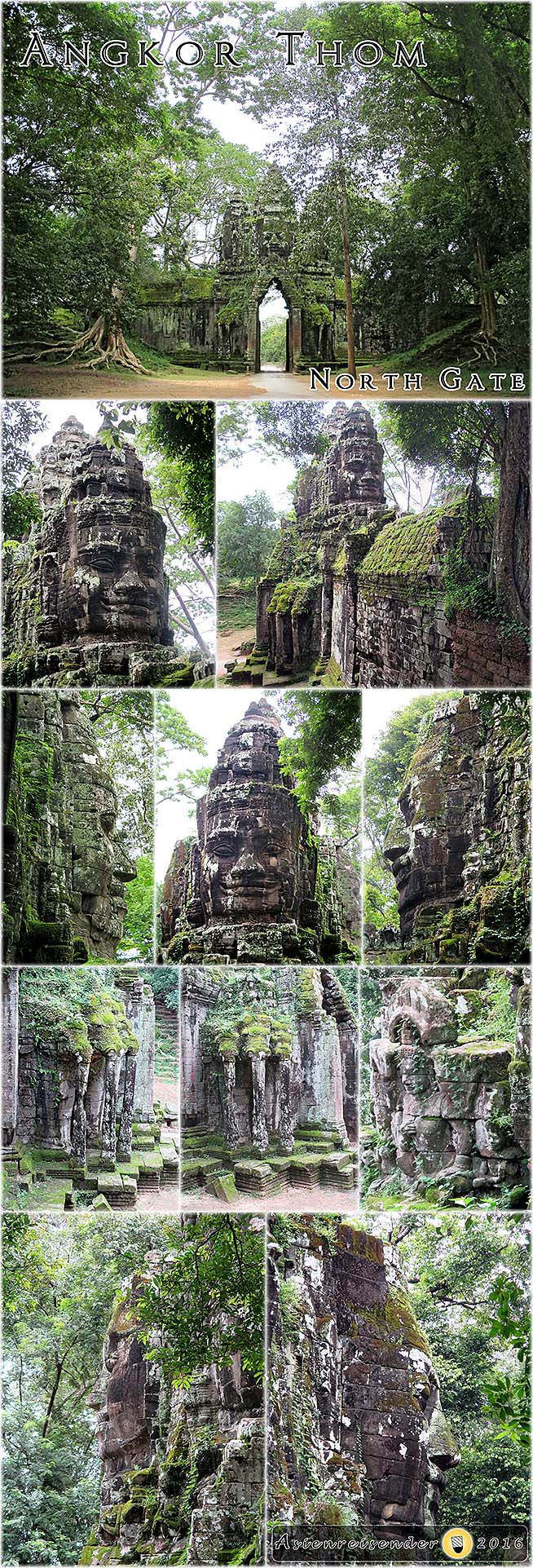
Inside there is a road net, which is connected to the outer area by five city gates. Basically there are two roads crossing the area and meeting in the center point, at the Bayon. From the Bayon these roads lead into the four compass directions to four of the gates. A fifth gate is placed north of the east gate. It's called the 'Victory Gate' and it's road, the 'Victory Road', is leading straight to the royal palace. Best known is Angkor Thom's south gate, the one which connects to the road to nearby Angkor Wat (just 1,700m away).
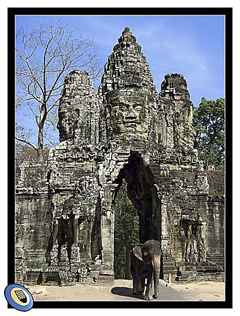
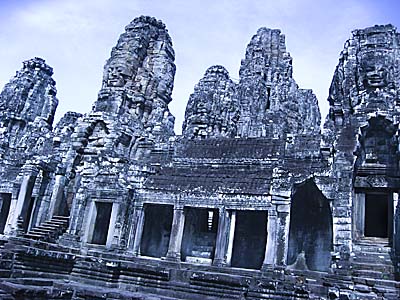
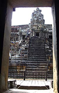
The South Gate
Angkor Thoms's south gate. It's the most famous of the five gates, for it's on the road to nearby Angkor Wat. Many tourists have a closer look at it, and much traffic is going through the gate now. Image by Asienreisender, 2006
The gates of the city wall are all very representative and show a giant head with four faces showing in all directions on the top of a towerlike construction (called 'gopuram'). Their height is 22m, the gate opening is 7m high and 3.50m wide, and therefore high enough to move through it on the back of an elephant. The city gates are made of sandstone and can cope in their quality with the ancient buildings of the old greek. In their original state they have been probably equipped with two heavy wooden doors and a massive bar to close the doors from inside.
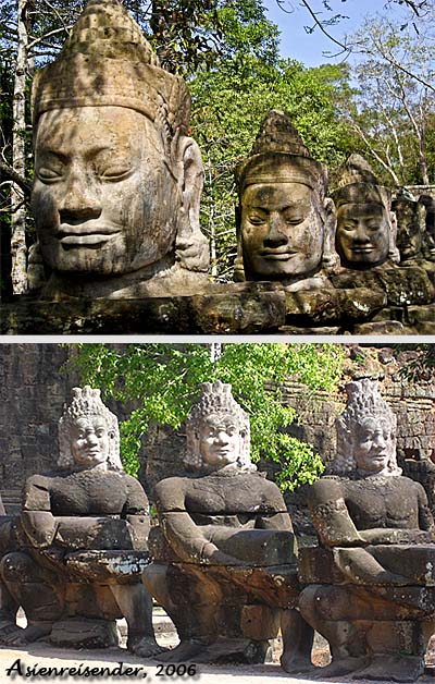
When approaching one of the gates from outside, one has to cross a wide naga bridge, which leads over the outer moat. On the right and left sides of the bridges are 54 gods and daemons placed, who carry two nagas.
The most important state buildings were concentrated inside the city walls of Angkor Thom. In the northwestern part was the king's palace, together with a temple pyramide called Phimeanakas. This construction was then extended by the Terrace of the Elephants, the Terrace of the Leper King and the great (victory) square, alltogether a great areal for military parades or presenting great representative games and shows.
Also remarkable are the mountainlike temple Baphuon and the two buildings called northern and southern Khleang, who were kind of halls placed opposite to the Terrace of the Elephants. Also opposite to the Terrace of the Elephants are two ponds and twelve towers called Prasat Suor Prat. In the geometrical center of the whole square-shaped arrangement of Angkor Thom is the famous and most outstanding Bayon placed.
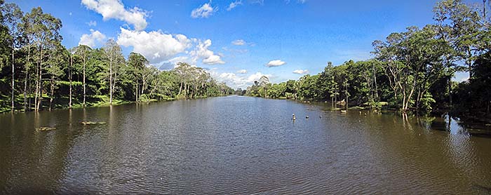
Besides, ancient Angkor was famous for it's sophisticated canal system. A dense grid of canals led through Angkor Thom. They partially served as a transport system, partially they were used as a freshwater source, as well as a bathroom and, not to forget, for wastewater disposal. The water flowed from the northeast to the southwest, drained eventually to the western baray (a rectangle-shaped, artificial lake) outside Angkor Thom. Probably the water was taken out of the Siem Reap River, using the natural gradient of the land towards the Tonle Sap Lake.
Angkor Thom's Moat
Angkor Thom's moat at the south side, seen from the naga bridge to the southern gate. It's 100m wide. Image by Asienreisender, 9/2015
It's remarkable that, despite the millions of international arrivals of tourists at Angkor nowadays, there has never been a Westerner in Angkor when it was still a vibrant capital of great significance. The first arriving Westerners at Angkor were some Portuguese who showed themselves impressed by Angkor Wat. It's not clear if they have seen much of Angkor Thom as well, for at this time it might have been overgrown by dense jungle already.
4.
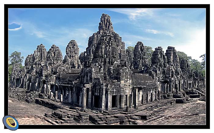
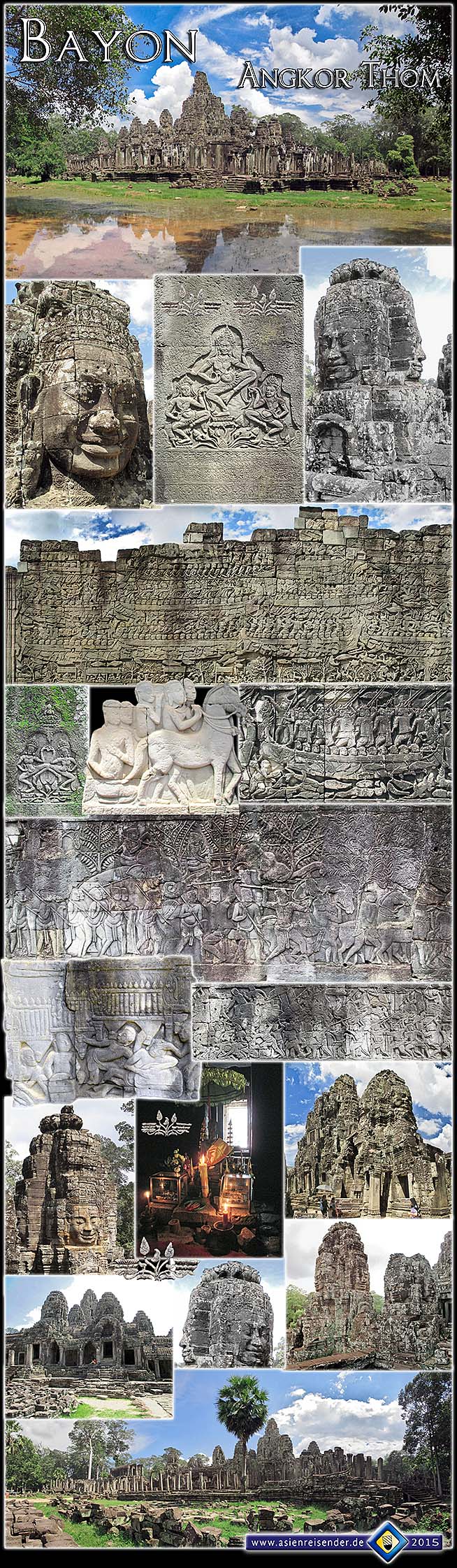
Bayon
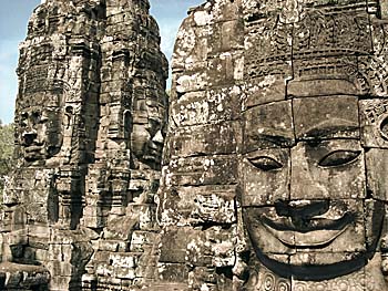
Jayavarman VII's state temple Bayon (originally: Madhyadri; Khmer: Prasat Bayon) is the second famous building of Angkor, following Angkor Wat. It's particularly impressive for it's well-known 200 Bodhisattva heads who look in every direction and 'see' everything. It's maybe kind of an early big brother project. It's also highly supposed that the face represents Jayavarman VII's own one, who was highly revered as a godking (dhamaraja), a new royal legitimation concept in difference to the former Hindu concept of a king as an incarnation of Shiva. A Bodhisattva is someone in the Buddhist mythology who has reached enlightenment, but decided not yet to enter nirvana, but instead to remain on earth for some more time to teach others and show them 'the way' (to reach enlightenment as well). That was, according to Buddhist mythology, what the real Buddha did.
The Inner Bayon
The Bayon, seen from the southwest, inside the outer ring, from the top of a heap of stones of a collapsed library. It's a construction of high complexity with a lot of details to discover. Like the verymost ancient temples in Southeast Asia there are no halls or large rooms inside, in contrast to the ancient Greek and Roman buildings of Europe's past. In the central dome are five small chambers, of who the central one is the biggest. Image by Asienreisender, 2006
The Bodhisattva faces at the Bayon wear a faint, subtle, very particular smile. It's the 'smile of Angkor'. A remarkable personal experience is that I found sometimes faces very similar like this with a similar expression at contemporary Southeast Asian people, even as far away as in Sumatra.
Guardian Daemons
Gods and demons as the balusters of the bridges to Angkor Thom. Although they are replications already, they get frequently beheaded and fall victim to art heist. Images by Asienreisender, 2006
It's an interesting fact that Jayavarman VII was the first Buddhist king of Angkor, changing the state religion from Hinduism to Mahayana Buddhism. That marks also a significant difference between Angkor Wat and the Bayon. Angkor Wat represents a classical piece of Hindu architecture. Despite the introduction of another religion, significant parts of the Khmer population of the time remained Hindus. Hinduism also had a reinvention under king Jayavarman VIII in the mid-13th century, before a third change of the state religion invited Theravada Buddhism, which is the dominating religion still nowadays in Cambodia.
However, the Bayon was dedicated to Buddha, and it was the only single state temple of Angkor referring primarily to Mahayana Buddhism. Besides it was the last state temple built in Angkor and the centerpiece of Jayavarmans VII's omnipresent building programme. Having a look for other Khmer temples in Cambodia or Thailand, in many of them is the name Jayavarman VII involved.
Significant for the Bayon are the already mentioned unique Bodhisattva faces; in all it's variations there are around 200 of them to find at the Bayon. Remarkable is also that the center part of the temple is round, and not square-shaped. The Bayon is not surrounded by a wall but by open walkways with pillars. Besides, the construction became repeatedly rearranged and altered over centuries and changed therefore it's original, first state considerably.
The central temple 'mountain' of the Bayon is neighboured by two galleries. Their walls show a series of reliefs. They show not only battle scenes of the Khmer wars against the Cham, but also scenes from the life of the king and the inhabitants of Angkor Thom. Other reliefs depict scenes from the Hindu mythology.
The Central Dome
The prasats and the central dome of the Bayon. Image by Asienreisender, 2006
Very interesting for a historian and an interested amateur are the depictions of the common people, because common people normally don't occur in the official records. There it's all about the kings, the states, the ruling classes, the big buildings and wars. All-day life wasn't worth for them to be mentioned. Though, here we find some music instruments of the time. Some of them are no more in use nowadays, some are still existing, but very rare in use anymore. Other scenes show a market with common people or people around their houses. However, most of the reliefs show indeed war scenes, army and navy.
A certain series of reliefs describes the fight of a king with a giant snake. The king is not armed, and later he get's his hands examined by women, ending up lying sick in bed. This might be an association with the 'leper king', who got, according to a legend, infected with leprosy in a fight with a serpent.
Written records from Angor don't exist anymore. Although the Khmer of the time had libraries to collect their writings, the material they used was mostly palm leaves and therefore not fit to stand the climatic conditions for long. It's as well eaten up by the tropical nature as the wooden buildings of the people of the time. The only single exception is not an Angkorean source but a Chinese. In 1296/97 CE a Chinese envoy, Zhou Daguan, spent a year in Angkor and wrote a report for his emperor, called 'The Customs of Cambodia'. This report survived in China and is nowadays also available in an English translation.
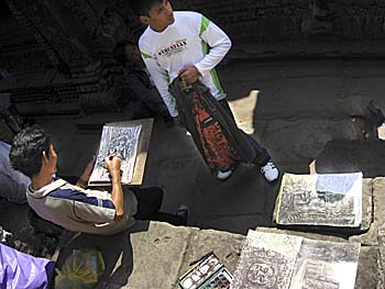
An artist, drawing sketches of the old temple ruins and the tourists at the foot of the Bayon. Image by Asienreisender, 2006
In later centuries new rivals arose in the northwestern part of the Angkorean empire. It were the Tai (Thai) kingdoms of Sukothai and others, who gained independence from Angkorean dominance. In 1431 CE Angkor was finally sacked by an army from one of these Thai kingdoms, Ayutthaya. From that defeat Angkor never recovered. The Khmer capital moved to the lower Mekong River and great parts of Angkor were abandoned. Although Angkor Wat was, as it seems, almost ever in use for spiritual and religious purposes, most of the other Angkorean temples, including the Bayon, were covered up by the jungle.
Nowadays the Bayon is, as verymost of the ancient buildings in Southeast Asia, in a far worse shape as it was at it's best times. Of the 49 original towers are only 37 left, many of these were also collapsed but are rebuilt. It's also so that the original buildings were covered with a fine mortar and coloured with paint. Practically nothing of that is left. We can only speculate how exactly the buildings looked in their original state.
Medieval Angkor was a highly militarized society. The abundace of food produced in the fertile plains around Tonle Sap Lake and from the lake itself allowed the empire to feed a huge army and to maintain a huge slave population, which drained permanently into the city from the conquered neighboured nations. Angkor's militarism is inscriped in the galleries of Angkor Wat and the Bayon. Bayon's bas reliefs show over and over troops, troops, troops in different variations, war elephants and knights on horses. Some depictions are battle scenes. The southeastern part of Bayon's bas reliefs shows over several meters in length and height the empire's large navy, and naval battle scenes against it's arch enemy, the Champas.
The many square-shaped pillars at the four access ways are bedecked with dancing apsaras, devine beings or, less devine, temple dancers of flesh and blood.
The most dominant impression of the monument is given by the many Boddhisatva faces who seem to watch anything what's going on in and around the temple. 'The godking sees everything, he can read even your dreams', might have been a saying in the time. And it was certainly the wanted effect.
There are several shrines in the temple, and the central dome houses the main sanctuary. Nowadays there are merely a few smaller relics inside. The room is not too spaceous, but it's several meters high up to the ceiling. The smell and excrements of bats are to sense and when I was there last time I saw a bat flying around in the chamber.
All images and photocomposition by Asienreisender, 9/10/2015
Due to the rise of tourism in Siem Reap, the loss of the natural rainforests in the wide surroundings, the rampant urbanization and probably additionally to the climate change, the ground water level in Angkor Archaeological Park is sinking. That means a heavy impact for the monuments in the park. The Bayon alone is sinking every year some centimeters into the sandy ground.
Nevertheless, environmental destruction is promoted and ongoing as quick as possible, for the sake of development. It's the goal of the Cambodian government to rise the number of tourists to Angkor from about 2 to 3 millions at the time up to 10 millions in the next years.
5.
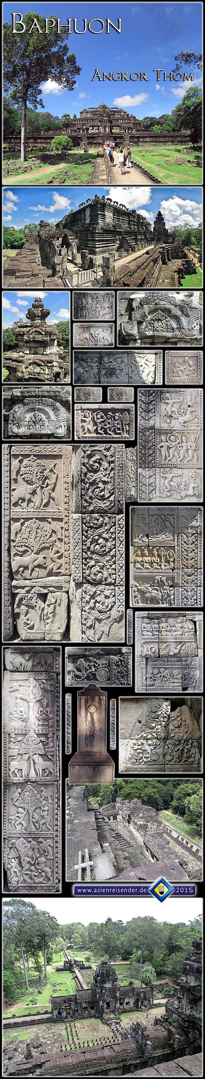
Baphuon
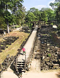
The long walkway to the Baphuon (here behind the photographer) with two western tourists photographing themselves. At the time the restoration of the Baphuon was still going on. Image by Asienreisender, 2006
There are plenty of more constructions in the 9km2 large areal of Angkor Thom. Not all of them were built in the reign of Jayavarman VII (1181-1206/1220). Some of them are older and were part of the former Angkorean capital of Yasodhapura, which was overlapping partially the same area. Other constructions were continued or altered in later times, particularly in the reign of Jayavarman VIII, who reverted the state religion back to Hinduism and destroyed a number of Buddhist sanctuaries.
An example for an older building is the Baphuon, which dates back to the mid-11th century. Baphuon is a monumental temple mountain and marked once the center of the older capital Yasodharapura; it therefore served as Yasodharapura's state temple as the Bayon did for Angkor Thom. It's a Hindu temple dedicated to Shiva. The Baphuon is also mentioned by the Chinese envoy Zhou Daguan.
Inmiddle of the Baphuon a tall bronze tower jutted out and gave the building an impressive look. In later centuries it collapsed, probably due to static weakness of the inner core.
This inner core of the construction was formed by an artificial earth hill. Most of the stone construction around the core is made of sandstone, only some outer walls were made of laterite.
Baphuon is placed not far northwest of the Bayon and closely south of the royal palace area. From the road between the Bayon and the northern gate one is passing the east gate of the Baphuon. One walks then on a 172m long walkway with a sandstone floor flanked by sandstone pillars. Passing through a pavillon at the end one reaches a terrace, which forms the base of a pyramid. A stairway now leads up to the base of the tower. At the terrace and the surrounding gangways are galleries who show scenes of the Hindu mythology and represent great quality of craftmanship.
Baphuon dates back a century before Angkor Wat, and was the central state temple of the time. It's a massive and steep building, which was in recent years completely restorated. Baphuon shows a number of well-restored fresquos, depicting legends and people of the time. The whole complex is built in sandstone.
All images and photocomposition by Asienreisender, 9/10/2015
Phimeanakas. A steep stairway leads up to the top. Image by Asienreisender, 2006
Pyramide-shaped Phimeanakas temple was built in the 11th century in the reign of Suryavarman I. It has a base of 36m to 28m and a height of 12m. Later it was integrated into the royal palace area of Jayavarman VII's Angkor Thom. Unfortunately no reliefs survived the tooth of time. At my last visit in 9/2015 it was impossible to cross the surrounding moat and to climb the monument.
Phimeanakas is the temple in which, according to an old legend, a serpent or naga lived. At nighttime the serpent would change into a woman and the king was obliged to make love with it to prevent Angkor from being ravaged by disaster.
Zhou Daguan noted that the temple consisted of gold. Maybe the tower or more parts of the building were covered with beatgold as it is to see still nowadays at many temples in Buddhist countries.
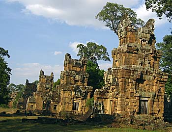
Phimeanakas
The main temple in Phimeanakas, Angkor Thom's palace area. Image by Asienreisender, 9/2015
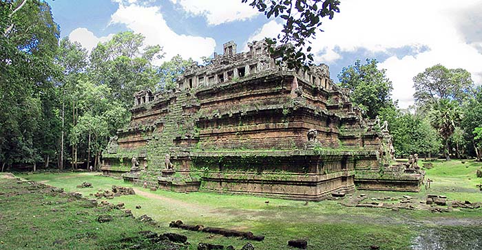
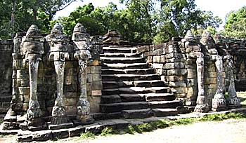
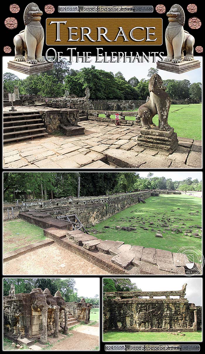
Terrace of the Elephants
Elephant Terraces
Terrace of the Elephants. Image by Asienreisender, 2006
The Terrace of the Elephants is a former tribune next to a wide, 350m long road (actually victory square) directly east of the royal palace and placed on the north-south axis between the Bayon and the northern gate of Angkor Thom. The road (victory square) served as a parade road for military units and to show games, processions and probably also competitions and fights.
The terraces consist of three different platforms to which five stairways lead. There are stone depictions of elephants left, and also of garudas, lions, gladiators and artists.
Zhou Daguan described that there were pavillions on the place and a number of more commodities. All this is gone after the centuries, and what's left is only the stony substance, the backbone of the place.
The Terrace of the Elephants
The tribunes of the royals and the nobility. In it's heydays it was part of the outer temple walls, covered with wooden frames and roofs. We have only a weak image of how it could have looked. No images of the wooden buildings are left, and they are all gone with the time. Images and photocomposition by Asienreisender, 9/10/2015
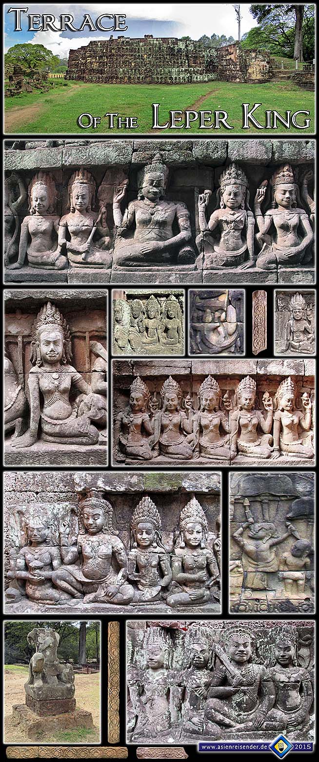
Leper King Terrace
North of the Terrace of the Elephants lies the Terrace of the Leper King. It was probably a place where the corpses of members of the royal family and the high nobility were cremated. The Terrace of the Leper King is remarkable due to a number of fine reliefs on it who are well conserved. For this reason the Leper King Terrace is valued as one of the best pieces of Khmer art.
It's not known who exactly let the terrace being built. Might have been Jayavarman VII as well, could have been Jayavarman VIII (reign approximately 1243-95 CE).
The terrace is named after a statue which is placed on it, depicting allegedly king Yasovarman I (reign 899-910 CE), the founder of Yasodharapura, who got infected with leprosy and died due to it. Another interpretation is that the statue represents Yama, the Hindu god of death. However, the statue there is a replication, while the original is in the national museum in Phnom Penh.
This place is supposed to have been a cremation site for the kings of Angkor. There was probably a crematory on top of the platform. The construction below served as a burial site for the ashes.
Now there are some statues on top of the platform. About one is speculation it could have been the leper king himself. It's a replica, the original is in the National Museum of Phnom Penh.
The walls are over and over carved with mostly high nobility with their many wives and concubines. Also some other depictions are to find, as the crocodile which catches a fish. There is also a narrow walkway between two high walls where are many more carvings. The carvings are seen by some as among the best what is left from the Angkorean culture.
All images and photocomposition by Asienreisender, 9/10/2015
Some of the towers of Prasat Suor Prat. Image by Asienreisender, 2006
Prasat Suor Prat
On the opposite site east of victory square is a chain of twelve towers placed. They are called Prasat Suor Prat. The tower chain is divided by victory road, which is leading from the royal palace to victory gate.
The towers are dated back by historians to the late 12th to the mid-13th century. Their basic shape is a square, their gates open to the west (the direction towards the royal palace) and include a small entrance hall. The other three walls have windows, in difference to other prasats who have normally closed, 'faked' windows at these spots.
The former function of the Prasat Suor Prat towers remains dubious. The name means 'towers of the rope-dancers', but it doesn't seem to make sense.
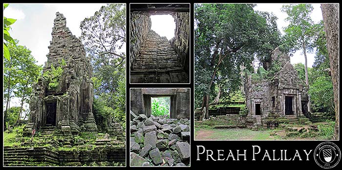
Preah Palilay
Buddhist temple Preah Palilay is a sandstone temple which is not clearly dated. Might be built in Jayavarman VII's time or hundred years earlier or later.
Preah Palilay is situated north of the royal palace, surrounded by forest. It's one of the remote buildings in Angkor Thom, and many tourists miss it. Remarkable here is the steep, high temple tower (prasat), who looks like a chimney. There are also some well-conserved reliefs to see, who show scenes from Buddha's life. This dedication to Buddha could be a hint for it's building time, for Buddhism was introduced after 1187 CE; except the reliefs were added later.
Preah Palilay
The chimneylike tower of Preah Palilay is collapsed, debris piles up where once the shrine was placed. The right image shows the entrance gate. Images and photocomposition by Asienreisender, 9/10/2015
More Buildings...
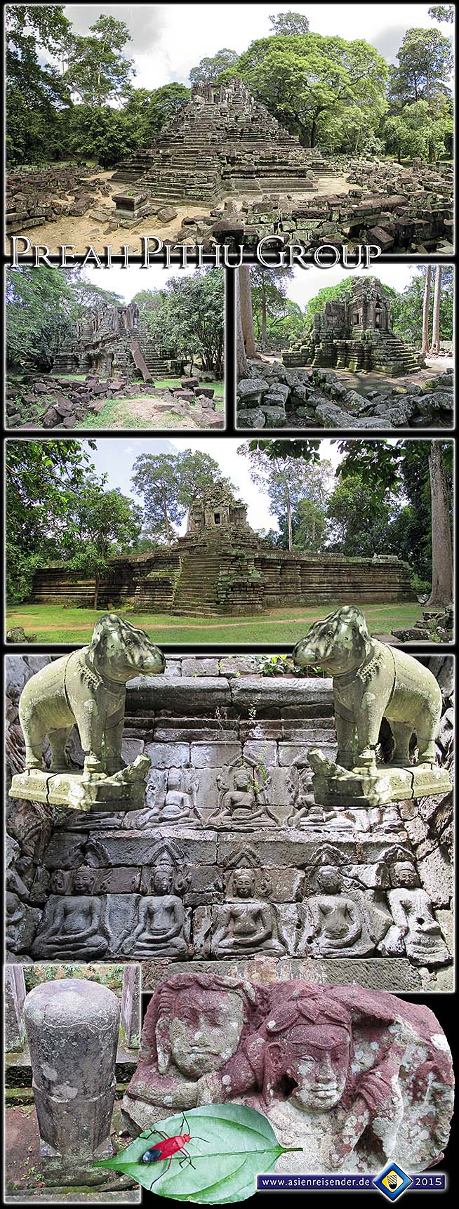
More constructions on the site of Angkor Thom are the Khleang, two halls closely east of Prasat Suor Prat, dated back to the early 11th century, the Mangalartha, the latest stone building built in Angkor, late 13th century, 'monument 486' which consists of three towers and dates back to the late time of the empire, Preah Pithu, a group of temple ruins, 12th to 13th century, Tep Pranam, a terrace with a Buddha statue and Vihear Prampil Loveng, a terrace on which nowadays the Buddha statue which was formerly placed in the central Bayon, is situated.
North of the towers of Prasat Suor Prat lies the hidden Preah Pithu Group, some seven or eight classical Khmer temples in the dense green. Very few visitors find the way to them and they give more than the other temples the impression of being forgotten remains of an ancient high-culture lost in the jungle.
All images and photocomposition by Asienreisender, 9/10/2015
A glance on the Baphuon while it was under restoration. At the time the site was closed for visitors. Image by Asienreisender, 2006
7.
Restoration
Restoration started in the time of French rule in Cambodia in the 20th century, but was interrupted in the world wars, the two Indochina wars, the Democratic Kampuchea years, the following Vietnamese occupation time... Since the early 1990s a number of international organisations take some care for the monuments of Angkor. The site is a UNESCO World Heritage since 1992.
A particular challenge was the restoration of the Baphuon. It was fallen apart in 300,000 single pieces and called 'the worlds largest puzzle' to solve for archeologists. A French team started with the restoration in the 1960s, but had to leave Cambodia in the war time when the Khmer Rouge took over power. The French team already sorted masses of stones and sticked numbers on them. Later all these records of the positions of the stones were lost, so that the resumption of the work was again a difficult task. Interestingly, any single stone was of an individual size and shape and had it's very certain place to be put in. The old Khmer builders didn't use mortar for their work, but precision. The restoration of the Baphuon was completed then in 2011. Since a perfect reconstruction is just impossible, a 10,000 stones were left over at the end. They now dot the floor around the Baphuon.
8.
LIDAR - Laser Revelations
A new lazer technology, called 'LIDAR' (Light detection and ranging), has been applied to Angkor and an area northwest of Angkor at Kulen Mountain in April 2012. LIDAR works from an airplane (at Angkor they used a helicopter), sending laser rays to the ground and measuring it out in a way much more precicely than other yet known methods. LIDAR penetrates dense vegetation and other covering shields on the ground and reveals patterns behind. It is also able to detect even small items of the size of a few centimeters, and not metal only.
Applying LIDAR, a large map of ancient Angkor could be reconstructed, including old 'highways', canals and many pools who were centered in blocks of flats. It also showed that Angkor was bigger and inhabited more people than previously supposed. The ancient city of Angkor covered a total size of 370 km2. A dense canal net existed in Angkor Thom, providing water in all parts of the city.
At Kulen Mountain the hidden ancient city of Mahendraparvata has been discovered in the jungle. Mahendraparvata was a greater Khmer city which dates back to the early days of the empire, the time of Jayavarman II and maybe before. It is 300 years older than Angkor Wat.
9.
Sources
This article is based on several visits to Angkor Thom. Moreover it's based on a number of publications. You find a list of them on the Literature page. Particularly John Tully's 'A Short History of Cambodia' and Maurice Glaize's 'The Monuments of the Angkor Group' were inspiring. It comes together with uncounted articles from newspapers, magazines, (qualified) websites and movies, both fiction and documentary. Sometimes, a good talk with a connoisseur of a certain topic provides me with facts, ideas, inspirations and innovations and/or reveals a mistake.