Anlong Veng
In the northwest of Cambodia, close to the Damrek Mountains who form the border to Thailand, lies the little place of Anlong Veng. It would be without any significance if there weren't two points. First, there is a border crossing between the two countries 15km north of town at Choam Pass; second, Anlong Veng was the last refuge of Pol Pot and the place where he died.
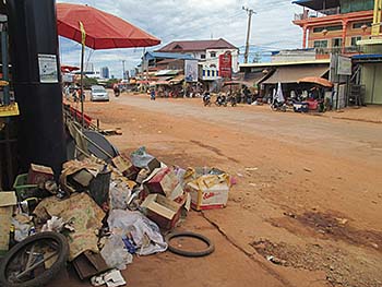
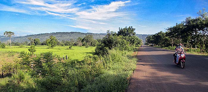
Four recently paved asphalt roads come together in Anlong Veng. They meet at the central roundabout. The photo was shot shortly south of the roundabout. It's Anlong Veng from it's better side. The side roads, all dirt roads, look much worse. Image by Asienreisender, 10/2015
The town itself is just a usual Khmer ulcer, dirty and ugly, with too much traffic already. The four main roads are meanwhile sealed and construction activity is spreading out in all directions.
There is practically no tourism, although there are some guesthouses. These guesthouses are propably for the Khmer who come here to visit the places of their former leaders.
Due to the remotness of the place the inhabitants are even more hillibillies than in many other places in Cambodia. However, there are some surprising exceptions of locals who appear generous and helpful. Or, at leasts one, to be precisely. Usually, Khmers are not hospitable and don't like to help. Maybe it's the closeness to Thailand which makes a little difference. Not few people here speak also fluent Thai.
There seems to live no Westerner permanently in this place, and one barely sees one who comes here for a short stop, spending at least a few hours in town.
It's very difficult to get half-way decent food here. The few restaurants are mostly so dirty and the food looks so poor, that one must be very hungry to go there. The trouble is that there is practically no alternative. In some cases the restaurant owners ask ridiculous high prices for their swines food, in others they ignore foreigners and don't serve them.
However, the climate is much more pleasant than in the plains as e.g. around Siem Reap and Battambang. The elevated altitude and the closeness to the Damrak Mountains make the area cooler and the air cleaner.
Anlong Veng is, to add that, a district town in the province of Oddar Meanchey.
Northeast of town stretches an artificial lake. The trunks of dead trees who still reach towards the sky indicate that the area has been flooded in a not too long time ago. The road north to Choam Pass towards Thailand crosses the dam, respectively spillover. It was built under the Khmer Rouge, who forced parts of the local population to do the work.
Anlong Veng Lake
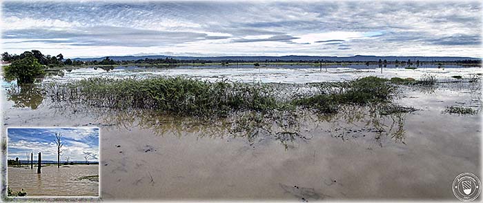
Anlong Veng Lake is wide, but seems to be not deep. This represents the highest level in mid October. The spillover at the western edge of the lake is pouring much water and therefore permanently draining the lake.
The mountains in the background are the Damrek Mountains, where the border to Thailand runs. Images and composition by Asienreisender, 10/2015
The area is also still heavily mined. So, it has by all means to be avoided to leave the roads or the tracks where people frequently go. Anywhere in the mined areas are also the killing fields of Anlong Veng. A series of massakers happened here after the downfall of Democratic Kampuchea. 3,000 people were blamed of being corrupted and got killed in the years between 1993 and 1997.
Ta Mok's House
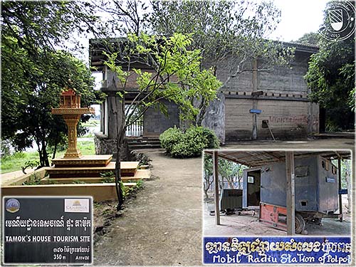
One of the weired tourist sites in Anlong Veng. To notice is also the spirit house... The vehicle was a mobile radio station, a propaganda vehicle for the Pol Pot faction of the Khmer Rouge. Images and photocomposition by Asienreisender, 10/2015
After the Vietnamese attack on Cambodia in late 1979 the country's urban centers were within a few days all in the hand of the Vietnamese. The Khmer Rouge withdrew into the jungles and particularly in the mountainous areas. That happened here. Part of Democratic Kampuchea's leadership, namely Pol Pot (brother no.1), Ta Mok, the war minister, Son Sen and Khieu Samphan withdrew to Anlong Veng. The graves of Pol Pot and Ta Mok are also to find here.
There are two houses of Ta Mok in Anlong Veng. One is at the best spot at the lake's shore. It's a tasteless concrete building with the charme of a prison at the end of a short dirt road. Some Khmers, particularly the government (tourist department) are shameless enough to make that a macabre tourist attraction. Entrance two dollars. The place is as filthy as practically any place in the country where locals spend time. No doubt there is a good deal of worship tourism here.
Choam Pass
Road 67 leads north out of town towards the Damrek Mountains. After some 12km the foot of the mountain chain is reached and the road swings in serpentines up to Choam Pass. The surroundings are forested here and give quite a contrast to the plains below. After another 3km the border to Thailand is reached. The Cambodian side of the border is a dreary spot with some ugly buildings, above all a bombastic casino for gamblers from Thailand. Just a few hundred meters from the border, east of the road where a dirt road leads to Heng Heng Guesthouse, is Pol Pot's burial site.
Pol Pot's Grave
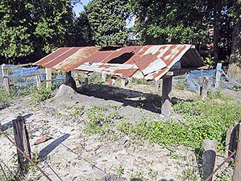
The burial site of the primeminister of Democratic Kampuchea, Saloth Sar, respectively Pol Pot (1925/28 - 1998). Image by Asienreisender, 10/2015
The spot looks by no means anyhow special. The grave is marked by a simple construction consisting of two poles and a tin roof. Around it a few flowers and a green net like a fence. Behind the grave are two spirit houses placed. Allegedly a Thai has spent the yellow one for he had a dream in which Pol Pot told him the correct numbers who won in the next lottery.
The site access is blocked by a rope. In a shack right to it was a small girl sleeping in a hammock. When I arrived, she awoke and ran away, calling for someone. After a while an old woman appeared and shouted at me the usual thing: "YOU PAY! YOU PAY TICKET! TWO DOLLARS!". That's how we like the Khmers, right?!
There are some more places of the leading Khmer Rouge in the surroundings, but I think it's hardly worth to visit them all. It's rather that the mountain scenery offers a beautiful stay, when the weather is not too bad. But, again: the area is heavily mined and one can not leave the ways without danger.
The Dangrek Mountains
The Dangrek Mountain Chain is a roughly 300km long mountain range and marks the border between Thailand (Isan) and Cambodia. It stretches in the east from the Emerald Triangle, where the borders of Thailand, Laos and Cambodia meet, to Khao Yai (mountain) in the west. The southern slopes, as to see on the image, are much steeper than the northern slopes in Thailand. The Dangrek Mountain Chain is actually a chain of not too high hills of whom the highest is merely 756m, few more reach over 600m. Much of the material consists of sandstone, of which the Angkorean temples in the wider area were built (see: Phanom Rung, Prasat Ta Muen and Phimai). The famous mountain temple Preah Vihear lies also in the Dangrek Mountains.
Illegal logging, arson and habitat loss on both sides of the border threaten the Dangrek Mountains as a refuge for rare animals and plants. Particularly rosewood has been logged in a large scale.
In the movie 'The Killing Fields' is the protagonist Pran fleeing Cambodia by passing the Dangrek Mountains. Image by Asienreisender, 10/2015
See also: 'The Dangrek Mountains at O'Smach'