Battambang
Just a couple of years ago, in early 2007, the city of Battambang was a sleepy, widely quiet place with dusty roads and little life on the streets. It appeared somewhat spooky, and the atmosphere was that I didn't actually felt too safe. That has drastically changed in the meantime.
Colonial Battambang
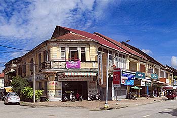
The three roads with colonial buildings mark the historical Battambang. All the older, wooden buildings are gone since long. The French came in here in 1907. Most of the city, around the inner core, is all brandnew. Image by Asienreisender, 9/2015
Develop- ment is rapid, and now Battambang is a bustling city which streets are crowded with the motorbike and automobile pest of our times. The city has expanded since and all the buildings are new or are restored. A total face-lifting happened. The building boom is going on and it looks like, if not worse, than Pakse. The city has allegedly 180,000 inhabitants and is the second biggest place in Cambodia.
Battambang has a short colonial history. It came to France under French pressure on Siam, which had to give it away in 1907. The French administration gave the place a solid layout in a chessboard pattern at the west bank of Sangke River (Stung Sangkae). This old, colonial Battambang is now seen as the cultural heart of the town. It consists of only three parallel roads aligned to the river. Two bridges were built in 1917. The old, colonial buildings have been somewhat restored. Since the colonial heritage of Phnom Penh, what had once the recommendation of being the most beautiful city in Asia, has been demolished by Cambodian 'city planning', Battambang is seen as the place in the country with one of the best preserved colonial heritages. Well, that's certainly no point to boast with. It is little compared to Luang Prabang, and also Kampot has greater potentials than Battambang.
Phsar Nath / The Old Main Market
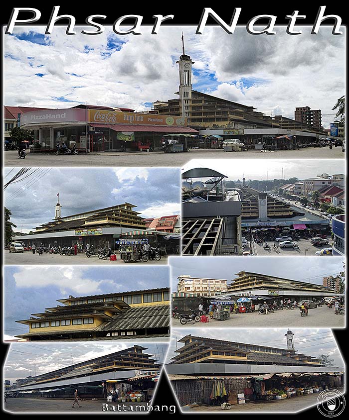
When the French built up modern Battambang, they added a new, representative market. Phsar Nath is the predecessor of Phsar Thmei in Phnom Penh, built in 1930, Art Deco style. The construction is a double-complex of two market halls. The division was made, maybe, to keep meat and fish apart from other commodities. Now it's all messed up. The easter hall is much smaller than the western hall, about one third of it. They are separated by about 40m empty space which is filled now with restaurants under tent roofs and large umbrellas. The high and sophisticated roof with the many windows allows an air circulation which is working like an air-conditioner.
For it's time it was a very modern building, a clear break with the classical colonial style, which was mostly neo-classicism. Clear, sober shapes, functionality dominates over the implementation of aesthetic details. The separation between art and purpose had been fully carried out in the early 20th century. The industries produce ever faster, cheaper, and usually more soulless.
The construction survived Democratic Kampuchea and is still in use as one among several other markets in town. The two bottom images were made in January 2007. There was little traffic around and still free space left inside the building. Now the traffic is desastrous, the whole public space is crammed with parking or rolling vehicles. Inside, the market is overfilled with shops and little space left for walking. The whole thing is since long run-down, neglected, filthy.
The western part is that with ordinary textiles, shoes etc. There are also fruits for sale, coffee stalls and some restaurants. As a foreigner one has to expect to be ripped off. The easter hall houses the gem and textile shops, hairdressers and tailors, among them the wedding-dress makers.
All images and photocomposition by Asienreisender, 2007, 2015
In 1938 Battambang was linked to Phnom Penh by a railway line. The railway triggered a first building boom along the track. A following, third urban development plan included the north and south of the city as well as the area east of Sangke River. This undertaking laid the foundation for Battambang being the second most developed place in Cambodia, after the capital.
Battambang's Railway Station
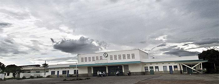
Another Art Deco building is the Railway Station. It's now, as so many public buildings in Cambodia, an empty shell. The railway tracks and the platforms behind the building are overgrown with tall grass and bushes. Talking is since years about restoring the line, but nothing has been done till now.
The line is part of the connection from Poipet via Phnom Penh - Kampot to Sihanoukville. Between Sihanoukville and Phnom Penh the line is running again on a low level. The whole development there gives a poor image, though. An Australian company is doing the work. Image by Asienreisender, 9/2015
The French development efforts were subsequently further realized by the first independent Cambodian governments in the 1950s and 1960s. The railway line was extended to the Thai border at Poipet and a number of more facilities were added to Battambang's infrastructure. Textile and garment factories produced here until the early 1970s.
The city of Battambang is still the second biggest in Cambodia. That means not much. Being on one of the higher buildings like Sky Hotel and having a view over the place from the roof terrace, one sees the city limits who are not too far away. However, in the town it is busy, noisy, crowded, smelly, chaotic and, at verymost places, quite filthy. On a dry day dust is whirled up by all the vehicles; after a bigger shower huge and deep pools appear on the roads. The sidewalks are neglected and crowded with motorbikes, cars, stalls and rubbish. Walking is a challenge due to all the obstacles and the traffic, who doesn't respect a walker on a sidewalk. The Khmer art of driving demands it's tribute also here.
As a traffic hub, Battambang connects the whole northwest of Cambodia with Phnom Penh and the eastern parts of the country. It is also a traffic hub for the western borders to Thailand, namely the bordercrossings at Poipet and Pailin.
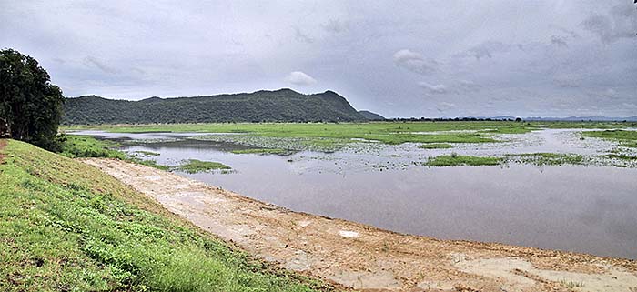
Tonle Sangkae (River), Battambang
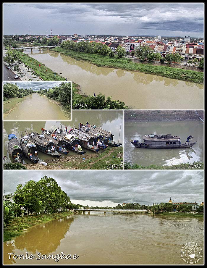
Battambangs river Tonle Sangkae comes out of the Cardamom Mountains in west Cambodia. The river was a main reason for the foundation of the city at it's banks. The Sangkae is feeding the Tonle Sap Lake which is already part of the Greater Mekong River system.
For the peak of the rainy season in September the water level is very low. The upper photo has been shot from the roof terrace of Sky Hotel at the east bank. A few days later, very suddenly, the water level rose considerably (photo bottom). That raises questions about the 'water management' of the river.
The small photo up left was made at the foot of Phnom Banan, what is about 15km south-southwest of Battambang city. The photos with the boats have been made in early 2007. Locals who live along the river banks and live from the river sell their products on their vessels who serve as floating shops.
The Sangkae is over most of it's course paralleled by roads to both sides. Following these roads out of Battambang shows that they are seamed by dwellings of different kinds. It is, of course, to expect that the water quality riverupwards of Battambang is much better than below the city, for there will be much wastewater drained into it, together with a lot of rubbish.
There is a boat service running between Battambang and Siem Reap, leading down the Sangkea and crossing Tonle Sap Lake. On the boat one can see a lot of the life of the local people on the river.
Although shorter in distance, the boat trip takes much longer than the bus does. The boat's engine is extremely loud and the boat is usually overcrowded with passengers. Also the driving style of the skippers is not better than that of the Khmer drivers on the road. When I came in 2007 on the boat from Siem Reap, we had a collision with another boat which quite suddenly appeared in a river's curve. The other boat was hit badly in the side and came out of course. It ran into the river banks on ground and almost razed two wooden houses.
In the evening of September 21st 2015, there was an extreme thunderstorm in Battambang. It came with a fierce storm, heavy rain and a power breakdown for about five hours. Many buildings got damaged and certainly people were hurt, maybe some killed. If a boat is surprised by such a storm on the Tonle Sap, one has to expect the worst.
All images and photocomposition by Asienreisender, 2007, 2015
The river banks are paralleled by sidewalks on both sides in town. They are also neglected, but safer than the other sidewalks. There is no remarkable life along the river; no restaurants or anything else where one could spend some time, exept a few benches. Where along the Mekong River in Laos or particularly in Thailand are usually restaurant boats or nice restaurants along the promenade - here is almost nothing of that. Generally there is no place in town where one could sit and rest in peace or relax for a while, except maybe some hidden restaurants like the roof terrace restaurant of Royal Hotel. That's changing slightly in the evenings, when one or two places open between the old and new bridges. These places are acceptable, offer food more expensive than elsewhere in town and are, at the early evening at least, not overcrowded. Remarkably, even there are video cameras placed in the trees to surveil the place. In case of a theft or raid, would the police catch the offenders? Ha, ha, ha... Or is it for the guests, who don't pay their bill?!
The Governor's Palace
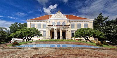
The colonial governor's palace dates probably back to the 1920s. It's now empty. Next door is a new, bigger administration building from the 1990s. Image by Asienreisender, 9/2015
North of the new bridge are some more places, where one gets food of dubious quality in the evenings for higher prices; but it's no place to spend some time here in peace for enjoying the river and having a talk. It's just to eat the fast food and to leave after.
At arrival I met a Western couple who claimed, Battambang wasn't touristic. In fact it is pretty touristic. There are many guesthouses and hotels, and at almost any corner are motorbike and tuktuk drivers announcing their services. 'Sir. Sir! SIR!!!' 'YOU, YOU!!!' and so on in many variations, sometimes very unconventional. Touts offer trips to the surrounding sights and some restaurants are targeting for tourists exclusively. The owner of Royal Hotel told me they were frequently booked out in the main season.
Cassava
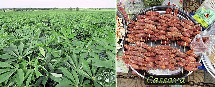
Cassava, also maniok or tapioca, is a vegetable widely grown in tropical and subtropical countries. It comes originally from South America. The edible part of it is the root. It's a fruitfully source of carbohydrates, but a poor one of proteins. Cassava is quite resistant against draughts, more than most other crops.
Around Kamping Puoy Lake are large cassava fields. More I have seen around Pailin.
Images and photocomposition by Asienreisender, 9/2015
Battambang Museum
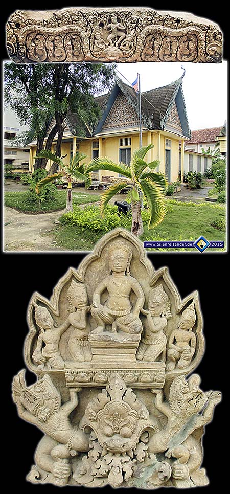
Battambang has a very small provincial museum with some pieces from surrounding Angkorean temples. A few of them are placed outside the building. Opening times are sparsely, and the employee I met there seemed to have the ambition to keep visitors on distance. Images and photocomposition by Asienreisender, 9/2015
Economy
The province's economy is mostly based on agriculture. Battambang is surrounded by fertile plains. Since it is possible here to harvest two times rice per year, the province exports rice into other parts of Cambodia and partially also abroad. It's the leading rice-producing province in the country. The high productivity makes the peasants here 'wealthier' than elsewhere. Vegetables and fruits (oranges) are also produced here. Tourism plays a smaller economic role in the province.
History
Battambang (rather: Battambong in pronunciation) was a foundation of the Khmer empire of Angkor. After the downfall of the Khmer empire around 1431 CE, the region came, at least repeatedly and for longer parts of history, under Siamese control. After the destruction of Ayutthaya in 1767, Siamese king Taksin (re-)conquered west Cambodia including Battambang and Siem Reap (Nakhon Siam in Thai). The province was then Siamese until 1907, when the Fench colonial empire set pressure on Siam to give it to France. In exchange, Siam got two formerly lost provinces back, that was Trat and Chanthaburi.
West Cambodia was annexed by Siam in 1942 again. After the Second World War, Siam had to give it back to French Indochina, respectively Cambodia, which was on the way to it's independence.
The local population is therefore since centuries a blend of Khmer, Thai, Chinese, Vietnamese and even some Laotians. Since at least the 20th century a few Westerners mixed in. It seems that the mentality here is somewhat different from that in south Cambodia, although one would have to stay here for a longer time to come to a more consistent conclusion.
The Sights of Battambang Province
The few sights around Battambang are all but spectacular. There are at least three Angkorean monuments around, but compared with those around Siem Reap they are of minor significance and in no good shape. The bamboo train is barely worth to be mentioned, and Phnom Sampeou is an easy trip up on a mountain top for enjoying the scenery. Near old Wat Samrong Knong are killing fields with a memorial building in which are bones and skulls preserved. Then there are the wetlands of Kamping Puoy, a newly dammed area.
Since 2007 the main roads improved very much from being disastrous to precarious. That means that they are at least paved and the mutual dust hazard repectively mud-slippery is no more. It's just that the fundaments are not stable enough for heavy vehicles, so that the trucks damage them quickly and they become uneven and potholes appear.
Wat Phnom Banan
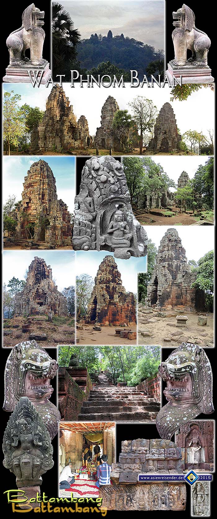
Maybe the most 'spectacular' sight in Battambang Province is Wat Phnom Banan, an Angkorean temple which has been built first in the mid-11th century and was then expanded and altered in the time of Jayavarman VII, means roughly around 1200 CE.
The temple site follows a typical Angkorean scheme aligned on an east-west axis. The access stairway leads up the easter slope. It's a longer and steep walk up here; the mountain is about 400m in altitude.
The mountain's top has been smoothed by the builders. They errected the classical five prasats (towers) symbolizing mythical Mount Meru; the middle tower is the main one and the highest. It's also the one which is built in the best material, a sandstone, while the outer prasats are built in laterite. Sandstone is the much better material to be carved.
There are not many carvings left. Most of the apsaras have lost their faces. They have been hewn out by art thefts. Might have happened in the war time already. The Khmer Rouge were eager to sell anything of value out abroad in exchange for arms and ammunition. Of course, the situation didn't improve till now. If there is something what can be stolen, it will be stolen.
At my first visit here in January 2007 (dry season), there was a view over the surroundings, at least partially. The vegetation was moderate, and many trees and bushes didn't have leaves. Now, in September 2015 (the peak of the southwest monsoon), everything is fat green. Besides, the trees grew in the meantime considerably and block the sight on the mountain's surroundings as well as partially on the monuments.
It seems that not much restoration work has been done in the meantime. Even the blocks who are scattered around on the ground remain in the same position as seven years ago. The easter prasat has been stabilized by a heavy, wooden structure, for it's going toward collaps in the western direction. The stairway has been improved. Unusually, the place is very clean, though, so that some care over it is taken.
Not many visitors find their way to Wat Banan. For the Khmers it's no easy place to go, for it's not possible to drive up the steep stairway with a Lexus SUV. Still, a few youngers make it. They go there for the purpose of worshiping local spirits, as it seems. The main prasat is occupied by an old man who put a lot of the usual accessoires one finds in these spots: Buddha idols, some pretty big, fruits, flowers, incense sticks, donation boxes and so on.
In 1859, Henri Mouhot paid a visit to Phnom Banan. He described the site in his book 'Travels into the Central Parts of Indochina'. At his time there have been many more remains, namely Buddha statues, who have since disappeared. At the base of the stairway and at some spots along it are stone lions placed. They are restorated and look quite impressive. At the base are also some of the old balustrades who show nagas and garudas, placed.
At the bottom of the mountain are a number of food stalls and restaurants. Entrance for foreigners three dollars US (Khmers pay usually a tenth of the price), parking costs extra, food and drinks all double price as normal, quality as low as normal.
After all, Wat Phnom Banan is an interesting, typical Angkorean temple site, but no great sensation for visitors. It can not cope with Ta Prohm south of Phnom Penh, which seems to be the best Angkorean sight out of Angkor itself. Ta Prohm is so great for the many carvings and details in the main prasat there, together with the relative good shape in which the whole compound is. It has obviously been thoroughly restorated. Also Phnom Chisor in Takeo Province can cope with Wat Banan. Phanom Rung in Isan/Thailand is anyway more impressing, as well as Prasat Muang Tam. The old sites in Thailand are generally in a much better shape than those in Cambodia, for the Thai Fine Arts Department does a great job in restauration, while in Cambodia it's neglected, except international organizations do what.
All images and photocomposition by Asienreisender, 2007, 2015
Wat Ek Phnom
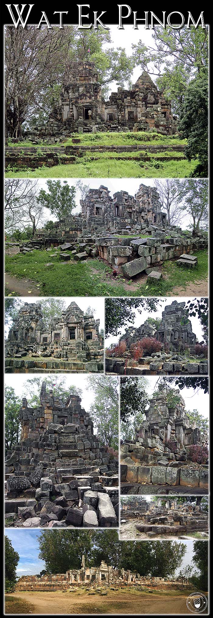
Another ancient stone heap around Battambang is Wat Ek Phnom. Built around a hundred years before Angkor Wat in the reign of king Suryavarman I, it's a classical hindu temple of the time. Unfortunately it was damaged in the Third Indochina War. The compound is surrounded by a moat with two accesses.
It needs urgently restoration, and there were some workers busy with doing whatsoever. I wonder, where the phnom (mountain) is, for it's all plain ground here.
Next door is a temporary buddhist temple ground with a school and a huge Buddha statue. There is also a cash box where foreigners are charged three dollars entrance. A nice village woman friendliest made me aquaintance with it already when she saw me approaching from far: "You pay ticket!". I made her the Obama in reply: "Yes, I pay!"
All images and photocomposition by Asienreisender, 2007, 2015
Wat Prasat Bassaet
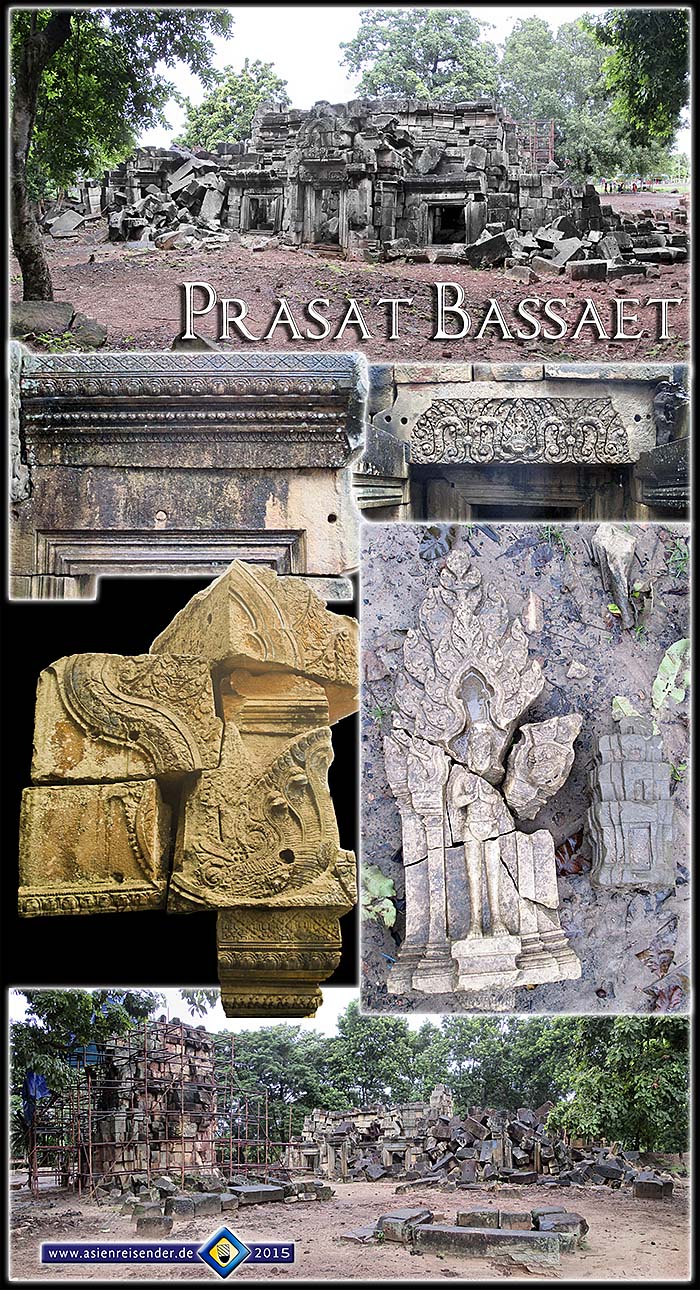
This site is the most down ruin among the ancient temples I visited here. It has completely collapsed. The prasat is, supposedly, the tower remain left in the image bottom with the metal construction around.
All images and photocomposition by Asienreisender, 9/2015
Phnom Sampeou
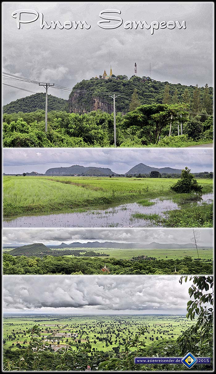
The 'ship hill' of Phnom Sampeou, also Phnom Sampov, is an about 100m high mountain with a monastery on top. The best thing about the mountain is that it grants a wide view over these typical Cambodian landscapes with its rice paddies, dotted with sugar palm trees and, in the northwest, another mountain massive.
Up on the mountain is a deep canyon, where Khmer Rouge dropped down prisoners. One can walk down there a long stairway and have a stroll in the small forest. The monastery and the two new temples nearby are nothing particular. They are built in concrete and also the wall paintings are not particularly good. A considerable building activity happened in the last seven years, and some new, paved concrete roads have been built as well.
Phnom Sampeou is also the place where thousands of bats leave their caves at dusk. The spectacle is to see from down at the ticket booth. One has to pay here again, indeed; it's another 3 US$ for foreigners.
Images and photocomposition by Asienreisender, 9/2015
Kamping Puoy Reservoir
A great irrigation project in Democratic Kampuchea, like that of the 'Secret Lake' in Kampot, was the dam between the two mountains Phnom Ku and Phnom Kamping Puoy, which stretches over a 1.9km in length and six kilometers in depth. Thousands of forced labourers (allegedly hundreds of thousands of so called 'new people') worked on the project, ill-equipped and underfed. The dam was built in about one year, mostly in 1977. As at any project of the Khmer Rouge, a lot of their victims died by fullfilling it. The main causes for the death of tenthousands workers were overwork, mistreatment, malnutrition and diseases.
This project is a revealing example for the real character of the so called Khmer Rouge. They were, above all, a terrorist group of bandits who came in power. Their ideology was rather ultranationalistic and insofar archreactionary as they used the methods of the admired medieval Khmer empire. Since they had no power over neighbouring nations as in the old times, they enslaved instead large parts of the Khmer polulation for their purposes. Without the slightest trace of intelligence they forced rice production as the only source of income and destroyed all the country's infrastructure as schools, hospitals, administration facilities, even the transport system. Without the Vietnamese intervention, the Khmers would have probably become the first nation in world's history who rooted itself out by commiting a national genocide. That's truly necrophile.
At a short stretch of the lakeside are some restaurants and bamboo huts for relaxation. In addition to the irrigation purposes are now hydropower installations planned.
Image by Asienreisender, 9/2015
Wat Samroung Knong
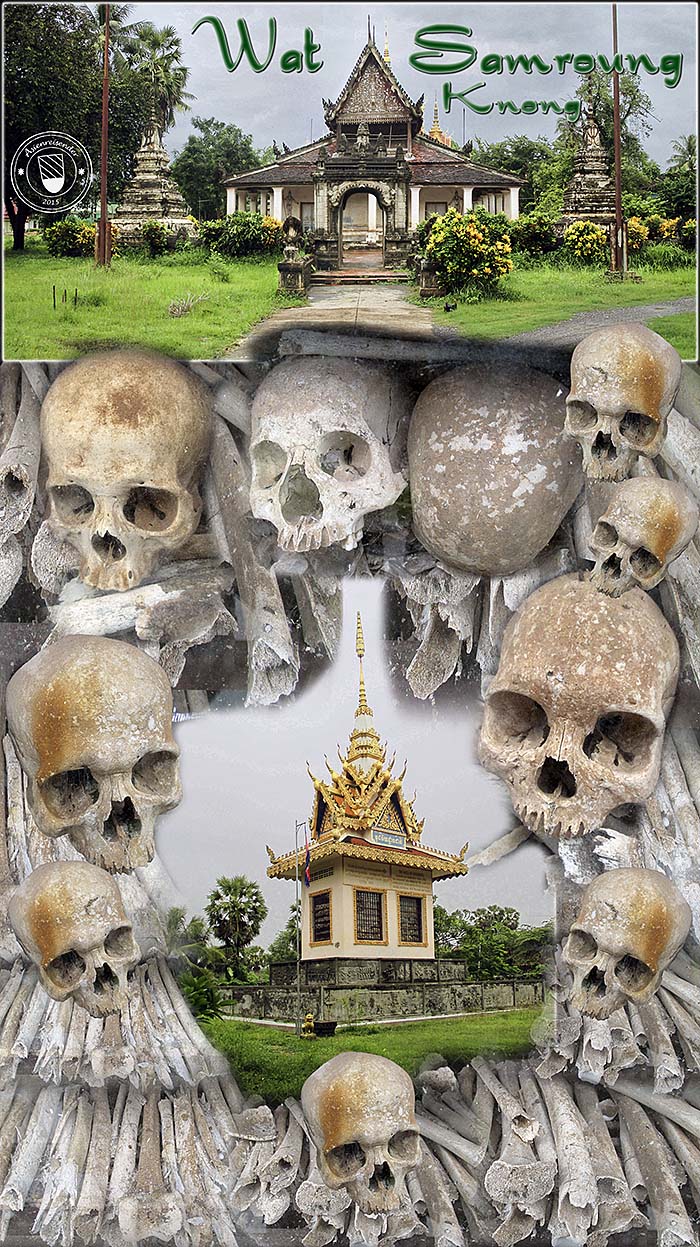
This buddhist monastry in the countryside outside of Battambang is exceptionally old. It was founded in 1707 CE. In the following decades and centuries the temple site was step by step expanded.
The temple had a bad time in Democratic Kampuchea. It was turned into a prison and torture camp and a site for forced labour in 1976. In the years until January 1979 there were 10,400 people killed and burried in mass graves. In the 1980s the graves were searched by villagers in the hope to find gold. Somewhat later a wooden pagoda was errected to house the remains of the victims. After years, the pagoda got rotten and became replaced by the contemporary building in 2008. A memorial plate on the wat's ground claims that the remains of 10,008 victims are inside, together with some torture materials like handcuffs and tie robes.
All images and photocomposition by Asienreisender, 9/2015
Nory, the Bamboo Train
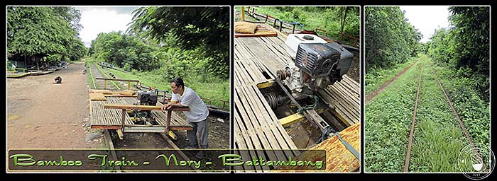
The nory is a basic construction of a wooden frame on two rail axes, driven on by a lawn-mower engine. It's running for seven kilometers on a section of the old Poipet - Battambang - Phnom Penh railway line. In the war years of the 1970s and 1980s, when the railways got heavily damaged and the trains couldn't go anymore, the nory was a substitute for the transport of goods.
Nowadays it's merely a tourist attraction. A drive to and fro costs 10 US$ for a single, three persons or more pay 5 US$ each. It's always stressed that the 'bamboo train' is a 'must go' for the tourists, although there is actually no real attraction in it. It's a symbol for the decline of a well-established transport system in a breakdown society.
Images and photocomposition by Asienreisender, 9/2015