Berastagi (Brastagi) / Indonesia

Asienreisender

1.

Berastagi Town / North Sumatra

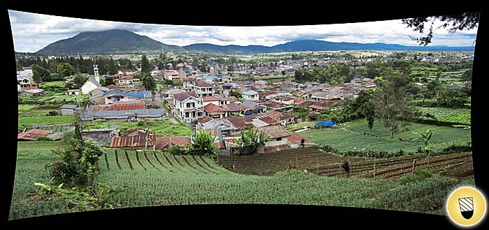
The Batak Karo town of Berastagi (rather: Brastagi, also spoken so) is a small place in the mountainous Batak Karo Highlands, north Sumatra. Situated inmiddle of the Barisan Mountain Chain with two impressing volcanoes in the neighbourhood, the place is attractive because of it's altitude of around 1,300m above sea level, what makes a nice, cool climate.

'Berastagi' by Asienreisender

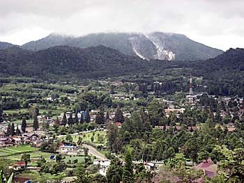
Berastagi, with the landscape dominating Gunung Sibayak behind. Image by Asienreisender, 2009

Coming from bustling and brutally hot Medan it's a real relief, and moreover the local guides are not that ambitious as they are in Bukit Lawang. However, still bad enough. The town's population consists mostly of Batak Karo People. The majority here are christians, a result of the missionary efforts of Ludwig Ingwer Nommensen and his successors in the 19th century. Nevertheless, there is a considerable muslim population living in and around Berastai as well. So, one won't miss here the mosques with their loudspeaker announcements.

Berastagi is roughly 66km away from Medan and about 50km from Lake Toba. One shouldn't forget the road conditions in Sumatra when considering distances here - 50km can be a long, long trip on a totally rotten, incredibly overcrowded and crammed full bus on roads who remind to the surface of the moon. Last time I made the trip I preferred to sit on the bus roof; however, here and there came a 'police warning', and everybody on the roof had to leave it and to crowd into the vehicle. Traffic police would make extra money out of it - it's officially not allowed to sit on the roof, although widely common.

Famous Bukit Lawang lies further northwest of Berastagi. It's not possible to go directly from here to there. To reach Bukit Lawang, one has to make the detour via Medan again. The next traffic-knot is in Kabanjahe, 11km south of Berastagi. There is the hub for several directions further into north Sumatra.

'Berastagi' by Asienreisender

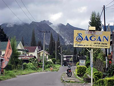
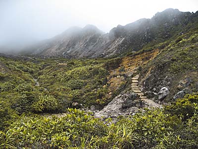
The outskirts of Berastagi, on the way up to Gunung Sibayak. Image by Asienreisender, 2009

The moderate climate was the reason for the Dutch colonial authorities in the 1920s to establish a hill station here for the colonial officers and the Dutch farmers in north Sumatra. Nowadays it's a holiday destination for people from Medan, and many wealthy Medan residents maintain a weekend- or holiday residence in Berastagi.

The town itself is a small spot consisting mostly of the main road which connects Medan and Kabanjahe. There is practically nothing of interest in Berastagi itself. A couple of sideroads give very poor impressions - it all looks slumlike, poor, dirty and ugly. If you like that, don't miss the fresh market. It's one of the dirtiest I saw in Southeast Asia, and I saw a lot. Chaos, crowd, rubbish everywhere, dead rats on the road with plenty of blowflies on them, the stench of rotten meat and fish... A walk through the market might spare you dinner - you save money and keep slim, that's great. Beer and alcohol in general is anyway far too expensive in this muslim country, so live is really healthy here.

One of the inner-town highlights is Gundaling Park, on a green hill nearby the town's center, equipped with a number of restaurants and more guesthouses. Near the market is the 'Combat Memorial' (Tugu Perjuangan), in memory of the 'Batak Wars' in the late 19th and early 20th century. At the other end of the main road is a 'Cabbage Monument' placed.

'Berastagi, seen from Gundaling Park' by Asienreisender

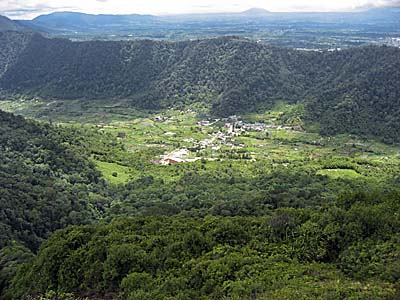
Berastagi (Brastagi), seen from the way up to Gundaling Park.

Image by Asienreisender, 2009

Many of the guesthouses have a poor price-performance ratio - old or run-down, a bit dirty, but not cheap. The Indonesians from Medan come in groups and sleep not seldom with eight or more people in a double room, means four or five occupy the beds and the rest sleeps on the ground. They don't mind and since they anyhow share the price it's no more that expensive per head.

The local agriculture is coined not so much by rice cultivation, but by crops who don't grow in the hot, tropical climate of the plains. Among them are cauliflower, radish, potatoes, peas, beans, cabbage, tomatoes, carrots and some more. Berastagi is famous for the production of passionfruit.

Map of Berastagi

'Map of Berastagi' by Asienreisender

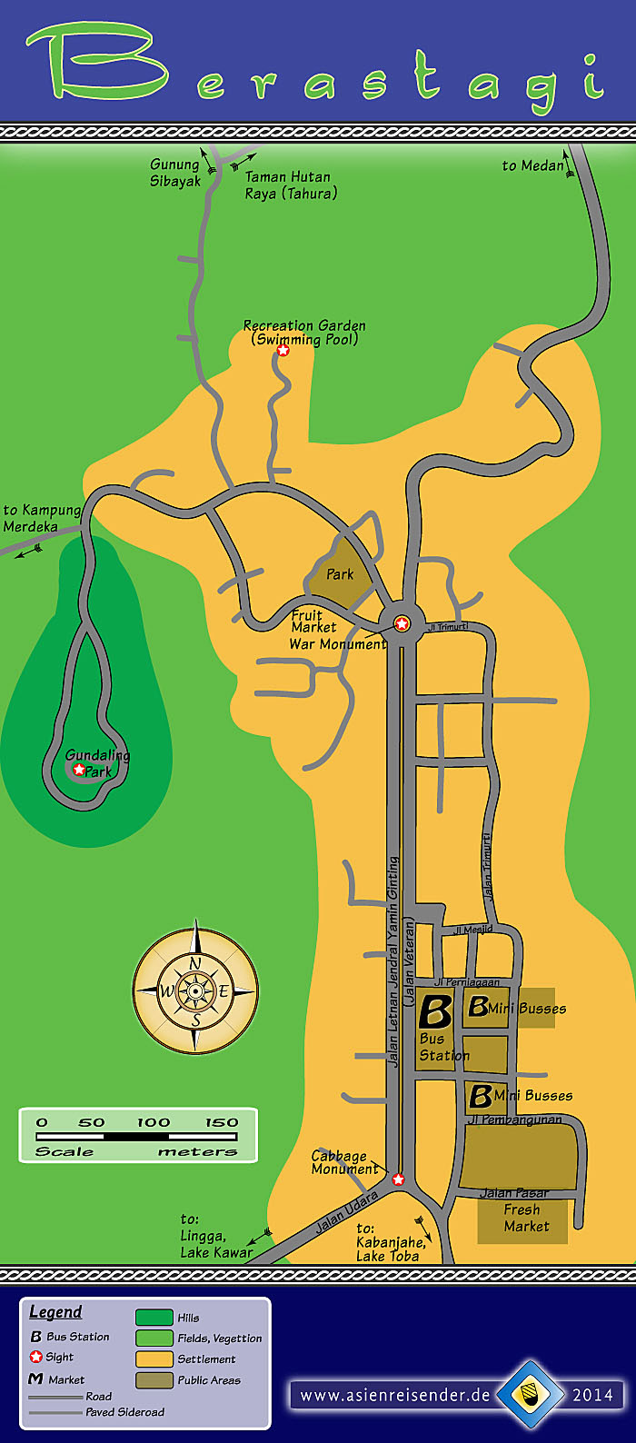
A map of Berastagi. The small place is easily to explore within a few hours. Like practically almost all the towns in Sumatra it's rather dirty and not particularly nice here. However, at least the outskirts give a much better impression.

The fact that the main road is aligned straight as a north-south axis indicates that it was first built by the Dutch colonial administration.

2.

The Volcanoes

The 'stars of the landscape' are the two volcanoes who coin the surroundings: Gunung Sibayak (2,095m) and Gunung Sinabung (2,454m), both are active. 'Gunung' is Indonesian for 'mountain'.

Gunung Sibayak

One can climb both; Sibayak is a relative easy walk a few kilometers through first a green surrounding and later over bar volcanic rocks. Being in an average physical condition, a guide is not necessary, although some guides claim it would be. When starting in Berastagi one follows a paved road through fields with vegetables until a point where a kind of cashbox is placed. There is always somebody to cash extra money for nothing; here it's about 5,000 rupees, might depend on one's face or the mood of the semi-official in the box. Then the way is still a small asphalt road winding slowly mountain upwards. One shouldn't miss the turn left into the dense green, almost at the end of the way. A series of steps leads further upwards through dense bushes. After leaving the vegetation the landscape changes to bar, volcanic rocks. Now it's no more far to the caldera of Mount Sibayak.

'Approaching Mount Sibayak's Peak' by Asienreisender

The last vegetation before reaching Mount Sibayak's crater. This is where the lava drained downwards when Sibayak had it's last outbreak.

Image by Asienreisender, 2009

The ground of the caldera is partially filled with a shallow water. Smoke and strange noises appear from holes in the rocks, there is a strong, foulish smell and the surface of the rocks are covered with sulphate, what gives them a yellow colour. Sometimes there are local people who collect sulphur into bags. Other visitors carved their names in the crater's ground. The best view one get's up on the antenna hill. It's a bit tricky to climb up there, the rocks are often slippery, but it's worth to go up. From the peak there is a fabulous view over the wider, mountainous landscapes. Most of the surrounding is covered with tropical rainforest. From here one can see alltogether four paths leading to the caldera. One is the one described from Berastagi; a second one leads down to a sidevalley with the village of Semangat Gunung to the nearby hot springs. Two others go into the jungle, and does the heck knows where they lead to. A number of hikers made the mistake to follow one or the other of these tracks and got lost in the jungle - some forever, not even their remains were found later. In the mid 1990s there was much talking and warning about raids happening here. A local gang had killed hiking tourists, among them a Dutch millionair. That could explain the complete disappearance of some people, 'cause if one get's killed and burried anywhere in the jungle, it's very difficult to find him afterwards, and I would suppose the local police is rather reluctant to make greater efforts to find lost people. Questionable is also the cabability of the police to do an effective research.

'A Side Valley betwen Mount Sibayak and Berastagi with the Hot Springs' by Asienreisender

On the ridge of Sibayak's caldera. The sidevalley down there with the village Semangat Gunung is a place with hot springs. The water is drained into several pools, and for a small fee one can enjoy a refreshing bath in one of them.

Image by Asienreisender, 2009

So, walking another way back makes us, after having enjoyed the majestic views over the half-way untouched landscapes, climbing the same track back we went up to antenna hill and keeping to the caldera ridge left. There is a path leading downwards on the other side. It's a long stairway down in the jungle now, and surrounded by much green one has to walk carefully because the ground is often wet and therefore slippery. The rungs of the stairway are designed for giants, so that one has practically to jump a lot. Once down the slope there appears another small road and this road leads to the hot springs. That's, by the way, a side-valley, separated from Berastagi by another mountain ridge. In the cool climate it's a pleasure to have a relaxing bath in one of the pools with hot, volcanic water. After that the small road a few kilometers later joins the main road between Medan and Berastagi. Here one has to catch a bus, what is not always easy and can take some time. Last time when I made the hike, the first three or four busses who came along were so overcrowded that they refused to take more passengers.

It's possible to make the way alone, but always better to have at least a companion in case something happens. It's good to have plenty of water in a small backpack. Walking half-naked with flip-flops is inappropriate. As always in the mountains, the weather can change rapidly, and in case of a sudden heavy rain there is around the caldera no place to shelter. A sudden fog, actually the appearance of clouds up here in the mountains in an altitude of around 2,000m, can be very disorienting. There is not a single sign marking the paths.

'Gunung (Mount) Sibayak, Photocomposition of ten Photos' by Asienreisender

A look into the devil's kitchen. The image top shows the view from antenna peak into the caldera. In the back of the caldera the drain of the last lava flow is clearly to see. It's where the track leads up. The way down to the hot springs is the track left, crossing the ridge.

Inside the caldera are a number of holes in the earth, where sulphureous gasses are extruded and sulphur is spit out, dissolved in boiling water. The crust of the earth is pretty thin here... Verymost of planet earth consists of hot, liquid iron, while the earth's crust is a rather thin layer, swimming on top of the extremely hot core below. The gasses, besides, can be dangerous and make one faint when inhaled.

A single man was working in the caldera, collecting sulphur in a bag.

The ground of the caldera is filled with a shallow water. Tourists formed names by laying stones. The picture below shows antenna peak in the background left, from where the first picture above was shot.

Images by Asienreisender, 2009, photocomposition 2014

Gunung Sinabung

Gunung Sinabung is also reachable from Berastagi, but it's not that easy. The distance is larger (12km) and the ways are not that easy to find. A local guide therefore seems necessary. It's maybe easier to start in Sigarang Garang, but it's not clear how the situation looks at the time this is written, due to the latest series of outbreaks.

Sinabung Mountain had a series of volcanic outbreaks starting in late August 2010. It was the first since about 400 years, so far geologists estimate. 27,000 people left the surroundings, and volcanic ashes from Sinabung even reached the megacity of Medan. In early September 2010 the volcano spit out a fountain of ashes which went kilometers up into the atmosphere. It was accompanied by a considerable earthquake. Almost exactly three years later Sinabung had another series of outbreaks, creating impressing smoke pillars and a lava stream (pyroclastic flow) running down the southeastern side of the mountain. The outbreaks lasted from September to November and required the evacuation of again tenthousands of local people from several villages.

More outbreaks followed in January and February 2014. Pyroclastic streams flowed down the flanks of the mountain, while in the smoke volcanic flashes appeared - a very rare phenomenon. A continuation of outbreaks is rather to expect...

'Tropical Rainforest coins the Batak Karo Highlands' - Asienreisender

Tropical Rainforest coins the Batak Karo Highlands. But, for how much longer? They are doomed. Urbanization is creeping in all the valleys and sidevalleys of the mountainous Barisan Mountain Chain. Roads are built and improved, electricity follows, more people, more cars, more rubbish, more need for resources. Everything is a merchandise in our time, and the rainforest and the nature generally are a self-service supermarket for those who can make any profit with it. The population here is increasing rapidly. Indonesians have many children. Nature is in retreat everywhere on this planet, even in the remotest places.

Image by Asienreisender, 2009

Asienreisender Up to the top!

Published on August 28th, 2014

188

Asienreisender