2.
Dieng Plateau -
Abode of the Gods
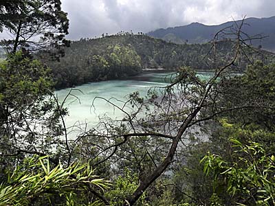
The high plain of the Dieng Plateau is a very peculiar landscape, an archaeological landscape, one can say. But it is more than that. Dieng Plateau is stretching over 14km in length and 6km in width. The genesis of Dieng Plateau was most probably triggered by a huge, historical volcano, who's outbreak left the plateau together with some new, succeeding volcanos. Together with a number of newer, smaller calderas the whole mountain scenery is called the Dieng Volcanic Complex. The volcanic Prahu Mountain is seen by geologists as forming the northeastern border of the caldera.
At around 750 CE a hindu priest cast established a culture up in the high marshland between the surrounding picturesque mountain peaks on the Dieng Plateau. Here they built the now oldest remaining stone buildings in Java. Dieng's original name Di-Hyang is translatable as the 'abode of the gods' (Di = abode; Hyang = gods). Sounds as the name would come from this medieval culture. These priests probably have been quite distinguished.
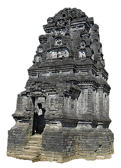
Candi Bima is placed on a higher altitude than the other temples, and it is a solitair. Candi Bima is the tallest and generally biggest of all the temples at Dieng. The design with the arc-niches and the sculptures inside make it, in my view, the prettiest of the monuments. The temples at Arjuna Complex look comparably sinister.
Image by Asienreisender, 2012
In the past there were more than 400 temples erected here, most of them are totally gone. Left are just eight, and they are thoroughly restored now. These buildings are not particularly large, but skillfully made. The original buildings were probably much more ornated as they appear now; however, they represent early Javanese hindu architecture.
This medieval culture survived for not very long, probably it lasted less than 200 years. There is unfortunately little known about it, because the Dieng civilization left no written records, at least nothing survived. There are no names of ancient kings or high-priests known. There are also practically no temple inscriptions who could give information about the ancient history of the site and the people who built and maintained it. Not even the name of the ancient city is known. Anyhow the culture declined and the site was abandoned. Remarkably, the downfall of the Sailendra dynasty and the cultures of Borobodur and Prambanan fall into the same time as the downfall on the Dieng Plateau. It might have to do with volcanic activities and earthquakes. Mount Merapi is supposed to have played a decicive role, maybe together with other volcanoes around. The environment changed and the high plains came under water.
Curiously, the re-discovery of the three main sights of Java, Borobodur, Prambanan and the temples of the Dieng Plateau, fall into the five years when Java was under British administration. A British officer re-discovered as the first Westerner that there were ancient temples on the plateau, what was partially covered with water. He realized the temples existence on the ground of a lake which was on the plain in that time. In the years 1840 and 1845 Franz Wilhelm Junghuhn researched the Dieng Plateau and created an excellent map of it. The Dutch archeologist van Kinsbergen drained the valley in 1856 and researched the before sunken, remaining ruins.
Arjuna Complex
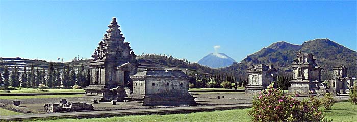
Arjuna complex, nearby Dieng village. It's the site with most of the temples - well, that's only five here. They were dedicated to the hindu god Shiva. As all the old hindu monuments they symbolize the hindu cosmos and are meaned as mountains after the model of mystical Mount Meru.
Now it looks like in a park; in the mid 1990s there were no paved ways, and the monuments merely stood on the grass. No guides and no tickets, neither.
The other few remaining temples are all in walking distance.
Image by Asienreisender, 2012
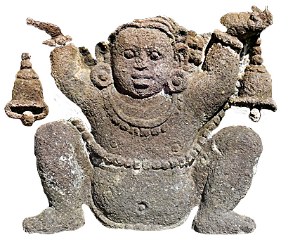
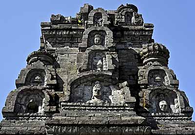
A smiling daemon is guarding a temple and watching what's going on around. The temples are square shaped, and there are always four daemons above the entrance gates and niches who are looking in all four directions. They all are individual, not two of them are identical. These deamon faces are the earliest architectural usage of demonic mascs in Java.
Image by Asienreisender, 2012
There is a small museum near the sites. It's not an overwhelming experience to visit it, but there are some figures and relicts from the temples displayed and some more information given about the nature and local culture. Most of the information is unfortunately in Indonesian language only and there is no brochure or anything else what would give more information about the site.
By the way: the temples are named after figures of the Wayang puppet games, based on the Mahabharata epos. However, the names are of younger age, the old, original names of the temples are unknown.
The Way to Dieng Plateau
Journey up to Dieng Plateau
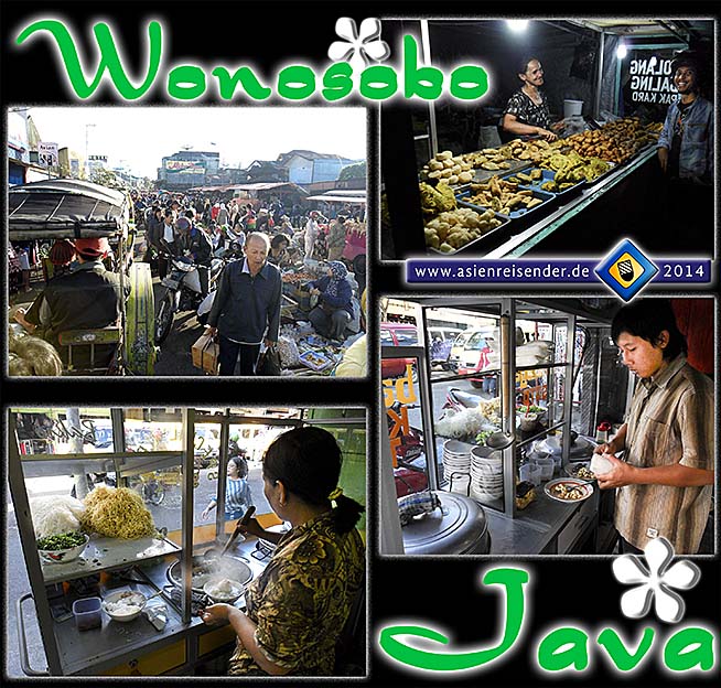
Wonosobo is the next city and kind of an entering point for the Dieng Plateau. The city itself is not particularly interesting; it's more or less a typical Javanese place. Wonosobo lies 900m above sea level, what makes the climate already pleasant. It also offered the better accommodation in the time being there last time (in 2012).
The villages, towns and cities of Java are mostly terrible; heavily neglected places where one can not live a healthy live. It's crowded, dirty, noisy and very chaotic. Everything around looks shabby, neglected, broken. It's only a world for the rich, who can barr themselves behind high walls in protected villas with great, green gardens around and staff who keeps their places up. Seems very much that this is how the close future looks for the whole planet - the slums grow, and the corrupt rich elities disconnect from the common crowd, the more and more superfluous human material.
The image top left shows not only the market place of Wonosobo, but it's actually a broad road, one of the main streets, inmiddle of the city. However, it's completely blocked with numerous most primitive stalls who mostly sell vegetables. Passing through here is a real challenge and takes plenty of time. The chaos and dirt are characterisic for empoverished places.
The Javanese cuisine is generally not so bad, but it's still usually not easy to get decent food. Much of the stuff is fast-food, fried and fatty/oily. Many of the street restaurants look so dirty that it's not very inviting to go there. The greatest variety of food is offered on the night markets - at around sunset the roads of the inner city are seamed with food vendors of different kind. Still, it was not so easy to get healthy food. It proved also helpful to buy somewhat for next day's breakfast already here in advance.
next ➧
Wonosobo is the next city and kind of an entering point for the Dieng Plateau. The city itself is not particularly interesting; it's more or less a typical Javanese place. Wonosobo lies 900m above sea level, what makes the climate already pleasant. It also offered the better accommodation in the time being there last time (in 2012).
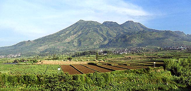
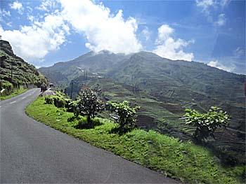
Close behind Wonosobo. The surroundings are coined by vegetable production already, and the Dieng Plateau is surrounded by bare mountains. Here we see Gunung Bisma, already part of the Dieng Volcanic Complex. Gunung Sikunir, the sunrise view point, is part of it and situated at it's right side, seen from here.
There is no doubt that these mountains, just a few years, not more than a few decades ago were covered with tropical rainforest. If one reads the description of Java less than 200 years ago in 'The History of Java' (1817/1830) by Thomas Stamford Raffles, it get's clear that this is a completely different, transformed country than it was in the past. In Raffle's times there were mostly parts of the northern coast inhabited by people, cities like Surabaya, Semarang, Cilacap and Batavia/Jakarta are mentioned, but they were small. The inner part of Java was widely unknown und covered with wilderness. Nowadays any square centimeter is used by the 140 million Javanese who live on the small island which is not bigger than England; and the population is still growing rapidly.
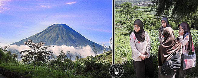
While Gunung Bisma above appears at the left side, the volcano here shows up a little later at the right side, when the plains around Wonosobo are already left and the bus is fighting his way up the serpentines. It's Gunung Sindoro, almost perfectly cone-shaped and therefore a typical volcanic mountain in Java. Sindoro, as a solitair situated northwest of Wonosobo and west of Dieng, is not part of the Dieng Volcanic Complex.
The girls were on their way to school, waiting for the bus to Wonosobo. Apparently they wear school uniforms who are designed in a military style.
next ➧
The first impression on Dieng, when leaving the bus, is pretty sad. The village sign is already broken and dirty and symbolizes the place therefore perfectly. A few guys are hanging lazily out in front of run-down restaurants with or without food.
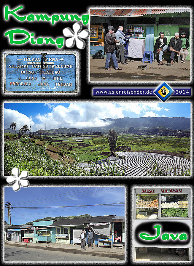
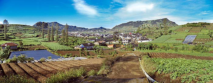
The panorama photo in the middle shows the Dieng Plateau seen from Candi Gatutkaca. The both shots below are done on the main road. Food is a bit a problem in Java. It's far not as good as in Malaysia. When coming from Thailand it's really a contrast. Where Chinese are living there might be some better restaurants, but depending on the Malay food alone is no pleasure.
next ➧
A few additional shots of the temples of the Dieng Plateau. The state of their restoration looks pretty good nowadays. The whole area with the temple sites looks pretty parklike meanwhile. Less than twenty years ago the temples stood inmiddle of the green, without signs, walkways or any other equipment as it appears now.
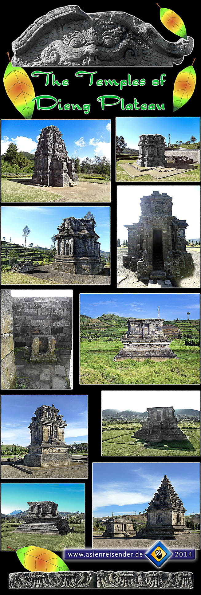
All the few remaining eight monuments on the Dieng Plateau are heavily guarded by daemons. And all of the ancient buildings are of rather small size, compared with other sights as Borobodur or Prambanan. They also don't look too friendly in their appearance, what is frequently so the case with these hindu temples.
Since there were about 400 of these temples on Dieng Plateau in the heyday of the sacral culture it can be considered as a greater temple city with a considerable number of inhabitants. There must have been a lot of more buildings for the people to live in; as usual the secularian buildings have been built from organic materials and are gone, particularly because the Dieng Plateau was for a long time flooded.
next ➧
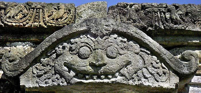
Here you get a few examples of the ornaments in the temples of Dieng Plateau. It's merely a faint reminiscence of what it once was - a very rich and sophisticated ornamentation of a whole temple city, probably painted in colours long gone and never to recover. In it's best times the city of Dieng Plateau, which name we don't even know, must have been a magnificient, blooming place.
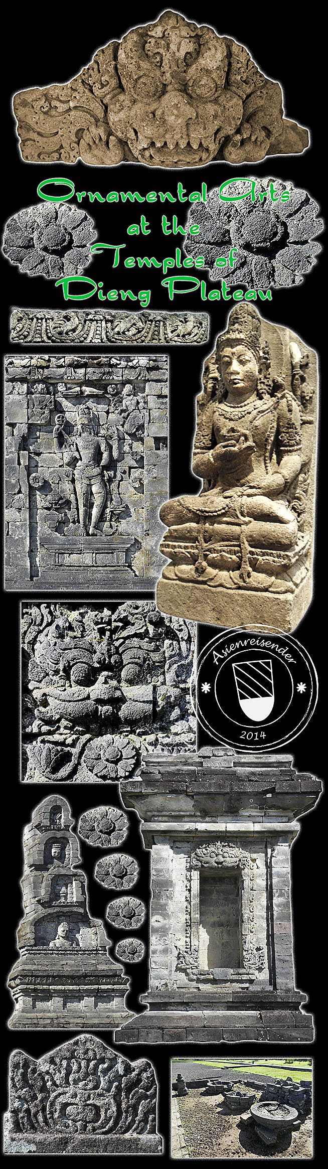
It's still surprising that some pieces of the Dieng art are still in a relative good shape. Restorators did a good job up here on the high plain. The small museum offers a few more pieces, a number of daemon masks and some statues of Shiva, Vishnu and other hindu deities. Certainly the Dutch colonialists, who cared first for the site, took pieces of art to the Netherlands.
first ➧
The accordeon gives a visual impression of the city of Wonosobo, the 'Gate to Dieng', and the way up to the high plains with the ancient temples, it's ornamentation, and Dieng Village.
Refresh
Click the chapters to enter the journey up to Dieng Plateau.
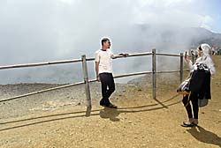
The Dieng Plateau was a major touristic destination in the 1980s and 1990s. In it's peak years until 1995 there were up to 50,000 foreign and 75,000 Indonesian visitors here at Dieng. In the following years the visitor numbers dropped sharply. After the fall of general Suharto's dictatorship in 1997/98 and the notorious Bali bombings of 2002 there were less than 1,500 foreign visitors here in 2003. At my last personal visit on the Dieng Plateau in May 2012 I didn't see a single Westerner at the temples, but some Indonesian visitors.
Map of Dieng Plateau
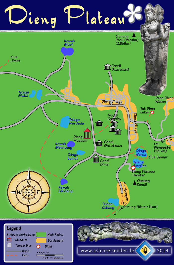
Please notice that the map is not in scale. Particularly the way to Sembungan respectively Gunung Sikunir (Mount Sikunir) is further than it appears here. The Dieng Plateau also expands further to the west, while the map is focused on the part with the temples and the mostly visited lakes around.