1.
Kampung Cham
The old colonial city of Kampong Cham is placed 125km southeast of the Cambodian capital Phnom Penh on the right banks of the Mekong River. It's the fourth biggest city in Cambodia (about 120,000 inhabitants), what does not mean much. The only really big city is Phnom Penh and all the others are rather towns. Nevertheless it's developing and growing fast. There is not much tourism in Kampong Cham; it lacks major tourist sights and does not offer much touristic activity for visitors.
The name of the place gives a hint to the local ethnic group living here, at least of the past. 'Kampong' means village (very similar to the Malayan word 'kampung', also for village) and 'Cham' refers to the Champa People. The Champa empire was one of the first empires in Southeast Asia and a long-term rival of the Khmer empire of Angkor.
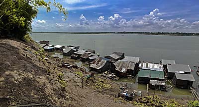
A floating village in the Mekong River in Kampong Cham. Image by Asienreisender, 2013
Since Cambodia had a severe 'break' in it's history, things are not so grown here as in countries like Thailand or Malaysia. After the Khmer Rouge seized power in 1975 they forced all city inhabitants to leave the urban centers and move to the countyside. The towns were abandoned and decayed. When people came back after the genocide, it mainly weren't the same people as lived here before. If there was a Cham majority living in the place before 1975, then it's no more so. The majority of inhabitants now is Khmer, but Cham People are an important minority. Due to that Chams are Muslims there is a higher number of Muslims living here than in most other places in Cambodia. That is also the case between Kampong Cham and Kratie, where a number of mosques are to see at the roadside.
It's here at Kampong Cham where the national road 7, which comes all the way down from Laos, is crossing the Mekong River on a big bridge. The Mekong around Kampung Cham is approximately 1,5km wide, but here where the bridge is placed it seems narrower. The bridge has been built by the Japanese government in 2001 and is called 'Kizuna Bridge', as a stone at the bridgehead in the town indicates. Allegedly it's the longest bridge over the Mekong River. Remarkably positive is that the bus station is near the town center.
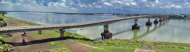
Kizuna Bridge over the Mekong River, seen from the old French Tower. Image by Asienreisender, 2013
There is a number of old colonial buildings left in town, meanwhile mostly renovated at least from the outside. More new buildings are built after.
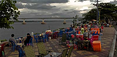
From early evening on the river promenade is filling with people. Image by Asienreisender, 2013
The river promenade looks also new and is wide and over the day pretty quiet. In the evenings it get's lively here when many foodstalls are opening and joining the little juice shops who sell sugar cane drinks over the day. Here are also a number of hotels and guesthouses. The river promenade stretches for a couple of kilometers and is probably the nicest part of the town.
In case of heavy rainfall, as I witnessed, the road parallel to the river promenade is quickly flooded. Although the Mekong is just a few meters aside and it's potentially easy to drain the water into the river, there are too few drains. They simply can't cope with much water in a short time.
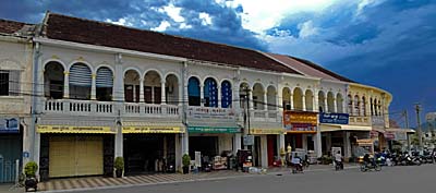
A front of typical colonial buildings, nicely restorated. In mid May rainy season is on the way. Image by Asienreisender, 2013
There is another wide boulevard leading through the city center with a broad green stripe in the middle. It's okay to have a walk along here because the traffic is not heavy. That might change within the next few years. West of the boulevard there are more wide roads with moderate traffic, seamed by bigger, representative buildings with greater gardens. The traffic concentrates on the national road. Therefore it's considerable quiet and clean in these parts of the town.
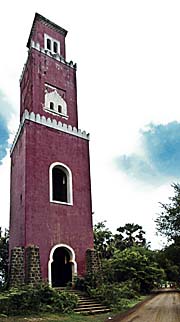
On the eastern side of the Mekong River there is a peculiar old French tower. It's a slim, tall building made of bricks and looks like a church tower but with oriental ornaments. Inside there is nothing but a rough iron ladder one can climb up. From upstairs there is a great view over Kizuma Bridge, Kampong Cham on the opposite river side and the surroundings east of the Mekong. The building is a landmark in the landscape and widely to see from some places in Kampung Cham and almost everywhere from the western river banks.
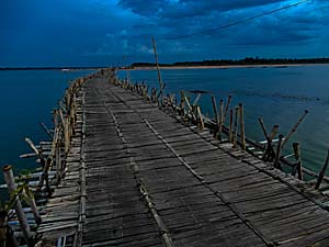
The bamboo bridge to Koh Paen at dusk. Image by Asienreisender, 2013
Following the river promenade to the south there is a long and solid bamboo bridge, leading to the river island Koh Paen. In fact it's the best bamboo bridge I have yet seen. It would be even strong enough for cars to pass over. In daytime there is not much traffic going to and fro, but that is changing in the late afternoons and evenings when many motorcyclists cross the bridge.
Anyway, in every rainy season the bridge is washed away by the stream, and every year at the beginning of the dry season it's rebuilt. Probably it's just a question of time when it will be replaced by a permanent-lasting concrete bridge. On Koh Paen is Cambodian countryside to visit, with some Cham and Khmer villages. Next to the bridgehead are a few simple restaurants with portable tables under parasols. Some are placed into the river, so that the guests sit in the shallow water.