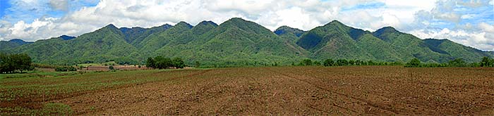
Landscapes are the result of many influences. They developed over long, long periods of earth's history. It contains a time span of four to five billion years in total. But it's not only physics and chemistry who formed the surface of the planet earth. The "blue planet" is a very particular planet among uncounted other luminaries. It has a particular atmosphere, containing 21% oxygen and is therefore able to develop and maintain life. Living beings then also formed the shape of the earth's surface very much. Except from oceans, lakes, ice capes and deserts the planets landmasses became mostly green, covered by plants. The outspread of life on earth was a long process as well. Big forests streched out, housing countless species of animals and plants. One of them separated in a significant way and developed to a self-reflecting being, able to think about it's own existence, where it might come from and that it will die. Homo sapiens. Not that we found any definite answers to the questions of our existence, but we can consider it. Animals can't.
The natural landscapes of Southeast Asia are dying fast and ever faster. Fire is a quick, cheap and brutal way to 'clear' natural habitats for different purposes. Legendary is the annual Southeast Asian Haze.
Additionally homo sapiens learned to deal with tools and to shape it's surroundings. Man learned to control fire as a first source of energy. Our species is just some 160.000 years old. That's a very short time compared with earth's history and the history of the evolution of the species. It made a breakthrough in development at the end of the last ice age. Nomads spread out worldwide and settled down. Husbandry and stock farming were invented as a safer and more productive kind of living. Man developed and shaped earth more and more, cutting forests, hunting some kinds of animals until their extinction. A big push happened at around 1750 C.E. with the first industrial revolution. Productivity raised enormously and the hunger for resources grew. Industrial infrastructure and the growth of huge cities shaped the surface of the earth in a rapid speed, how it never before happened in earth's history. The destruction of the natural environment and the influence of people is to see everywhere on this planet nowadays. And the process of influencing and destroying the natural environment is even still accelerating. It looks very much as if it were the endgame of mankind. That's the background we have to be aware of when we are having a look for landscapes.
Landscapes include urbanized areas and cities as well. They are landscapes covered in concrete and asphalt, but still landscapes.
Many things change very fast nowadays. Cities like Delhi, Jakarta, Singapore, Bangkok, Kuala Lumpur and many, many others develop so quickly, that some of them change totally whithin a few years. Vientiane in Laos is on the way, every view months it's changed. Kota Baru, situated on the east coast of the Malayan peninsula changed so thoroughly between 2005 and 2010 that it is barely recognizable.
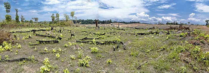
But it's not only the cities who grow. Also the countrysides and the natural habitats like primary jungle are changing. They change for the benefit of industrialized agriculture, for producing goods for the world market, for cheap consumption, consumer goods ending up as rubbish and pollution. The impact of the destruction is therefore not repairable anymore. Extinct species never come back. Primary forests developed over tenthousand of years with all the species living in them. All the different habitats are unique, once destroyed they will never reappear. Where the big tropic rain forests once streched out in Indonesia and Malaysia the traveller sees today only monocultures of palm and rubber trees. Elsewhere slashed and burned primary jungle is reforested by eucalyptus trees or other fast growing trees to supply the paper, construction or furniture industries.
These landscapes might even look nice and green. It's not about the look. Development means a big loss of biodiversity.
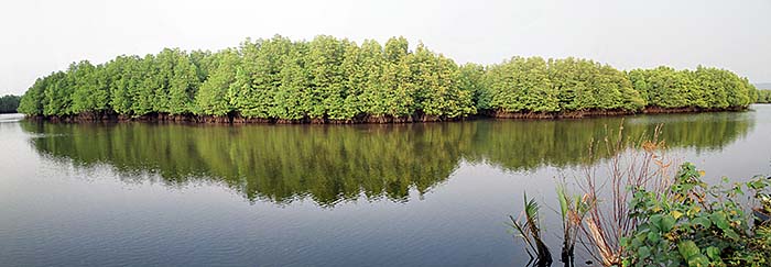
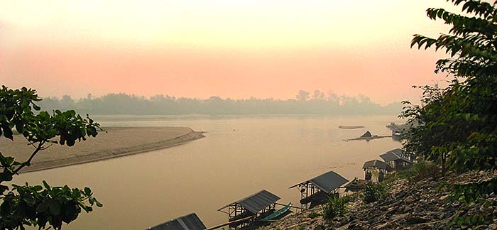
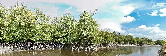
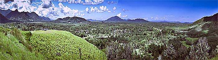
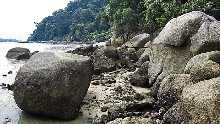
Mangrove River Landscape
Long coastlines with many rivers, covered with mangrove forests, are typical landscapes in Southeast Asia. In the past most of the long shores of the world region looked so or similar like here in Koh Kong Province, Cambodia. Image by Asienreisender, 2/2016
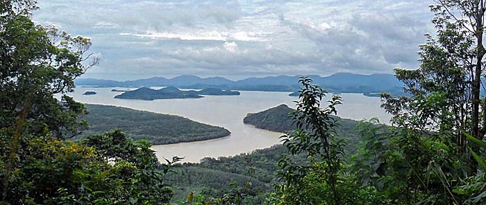
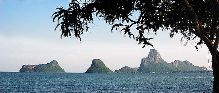
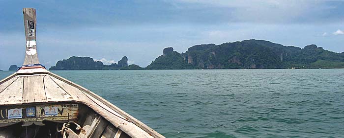
The Andaman Sea
The Andaman Sea is part of the Indian Ocean. The largest parts of it run along the Burmese/Myanmar coasts and further south it continues along the Thai coast. A great number of islands are dotting the Andaman Sea; in the west it's bordered by the Andaman Islands, the Nicobar Islands and, in the very south, by Sumatra and the Strait of Malacca.
The Andaman Sea near the Isthmus of Kra in Ranong Province / Thailand. Opposite site is a peninsula which belongs to Burma; further south it runs out in a cape called 'Victoria Point' with the Burmese town Kawthaung. Image by Asienreisender, 2012
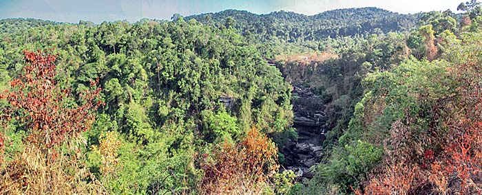
The Areng Valley
The Areng Valley is a 400,000 hectars large, mixed natural and cultural landscape in the Cardamom Mountains. Originally it was mostly covered with virgin tropical rainforest and is home to hundreds of tropical animal species, among them 31 who are endangered or critically engangered. In the middle of the valley, which is bordered to the east and west by high mountain ridges, flows the Areng River. The widely untouched forest river comes from the mountainous north and drains at Botum Sakor National Park into the Gulf of Thailand.
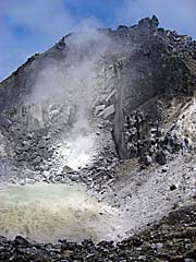
The caldera of Mount Sibayak. Image by Asienreisender, 2009
Berastagi | Karo Batak Highlands / Sumatra
Berastagi in the Batak Karo Highlands of north Sumatra was once a Dutch hill station for the reason of it's cool climate in an altitude of around 1,300m. Berastagi town itself is not an attractive place to go, but the surroundings are splendid. In the direct neighbourhood are two volcanoes, Mount (Gunung) Sibayak and Gunung Sinabung. Climbing Sibayak is relatively easy, but one has to be aware of the dangers here: there are long lists of people who got lost here while hiking. Some 12km away from Berastagi lies Gunung Sinabung, a volcano who has an ongoing series of outbreaks since 2010. When travelling from Medan to Lake Toba, it's defenitely worth to make the detour via Berastagi.
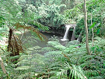
The forested, mountainous area of Bokor National Park, part of the few remaining islands of primary forest in Cambodia, still houses a decreasing number of animals and some waterfalls. Among the attractions is the old Bokor Palace Hotel & Casino on Bokor Hill Station and Popokvil Waterfall.
Right: Popokvil waterfall. Image by Asienreisender, 2013
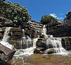
Bolaven Plateau is a huge area, stretching some 10,000km2 out through the mountains. It's not densly inhabited by a number of hill tribes who belong mostly to the Mon/Khmer linguistic family. The largest tribe are the Laven, after them the plateau is named: 'Bo Laven', means 'home of the Laven'. Until recent years the hill people could still live in their old patterns...
The picture right shows Tam Chan Pee Waterfall, one of the little frequented ones. There are a lot of waterfalls on Bolaven Plateau. It's one of the picturesque landscapes who were a paradise for wildlife in the past, but suffering severe destruction since the 1960s. Image: Asienreisender, 2013
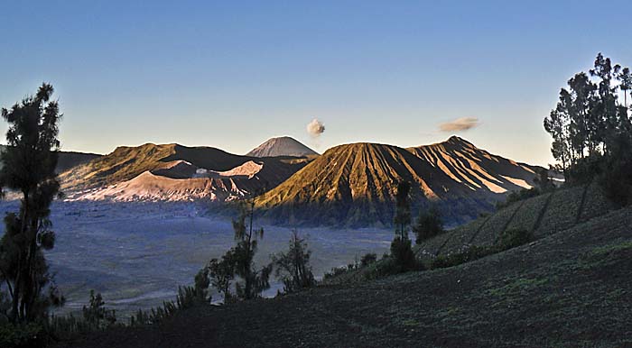
Mount Bromo / Java
One of the most spectacular landscapes on Java is defenitely the surrounding of Mount Bromo and it's neighbouring volcanos and mountains in Bromo-Tengger-Semeru National Park. Bromo, one of the most active volcanos on Java itself is one of the big 'stars' among the sights on the island.
Mount Bromo (the small crater mountain on the left) and it's neighbours. The two clouds come out of Mount Semeru, the tall volcano in the background. He is every ten to fiveteen minutes emitting one. They get drifted away by the wind. Semeru is the highest mountain on Java.
Image by Asienreisender, 2012
Cameron Highlands / Malaysia
The Cameron Highlands are a rolling high-plateau in peninsular Malaysia. They got their name after William Cameron, the first land surveyor who explored the forested terrain. The British colonial authorities decided to creat a health resort here in the mountains, for the cool climate is a great relief for Westerners living in the tropes. Since then, the landscape is getting more and more urbanized.
The Dangrek Mountains stretch over some 300km from east to west and form the geographical border between the Cambodian low plains and the elevated landscapes of the Khorat Plateau, Thailands northeast (Isan). It's a middle-high mountain range with few peaks reaching above 600m. Remarkable places are the Angkorean temple site of Preah Vihear and the lesser known little jewel of Prasat Ta Muen. The forests of the Dangrek Mountains around Anlong Veng were the last hideouts of Pol Pot's faction of the Khmer Rouge until 1999.
The Dangrek Mountains decline sharply northwards into the alluvial Cambodian plain. It's easy to imagine this scenery as the coast of an ancient sea. This mountain range is long, but not wide. Only a few kilometers south it lowers much softer into the Khorat Plateau (see: Isan), which is much higher in altitude. Image by Asienreisender, O'Smach, 12/2015
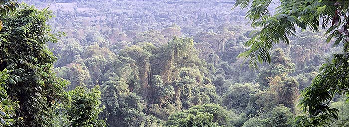
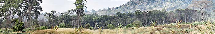
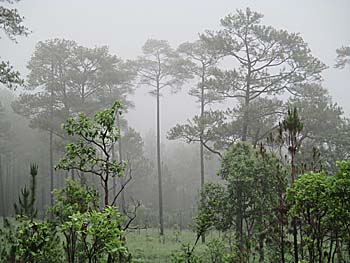
Deciduous Monsoon Forest
A typical and once widespread biotope in Southeast Asia is the deciduous monsoon forest. Together with tropical rainforests, they covered most of the landscapes in the past. Monsoon forests are, unlike tropical rainforests, adapted to months-long dry seasons when many of the trees shed their leaves. Although less rich in biodiversity than the rainforests, they still inhabit a large variety of plants and animals.
At around 750 CE a hindu priest cast established a temple city up in the high marshland between the surrounding picturesque mountain peaks on Dieng Plateau. Here they built the now oldest temples on Java. But this site is not only an archeological landscape, but also the caldera of an ancient volcano who blew up some 16,000 years ago and formed the high plateau with a hundred of smaller craters, lakes and ponds who are still volcanic.
Part of the Dieng Plateau, with Dieng Village (Kampung Dieng) in the background, on 2093 m altitude.
Image by Asienreisender, 2012
The Golden Triangle
At the confluence of Ruak and Mekong River, where the three countries Thailand, Laos and Burma/Myanmar touch each other, lies the geographical centerpoint of the Golden Triangle (in Thai: Sop Ruak). However, the region called the Greater Golden Triangle spans over a much larger territory, including parts of north Thailand, north Laos, parts of Yunnan (north China) and parts of Burma/Myanmar. Notorious became the region due to the vivid opium production, and still it has a recommendation for drug production and smuggling.
The Gulf of Thailand is a relative shallow arm of the South China Sea and the Pacific Ocean. Most of it's coastlines belong to Thailand, additionally the whole Cambodian shores, parts of south Vietnam and Malaysia.
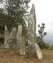
Hintang Archaeological Park / Landscape is one of the rare and mystical places left to visit for people who are willing to leave the beaten tracks. Situated in the northeast of Laos, some 60km out of unknown Xam Neua, inmiddle in the subtropical forests are the remains of an ancient culture to find. What they left are numerous groups of menhirs, and below them are burial chambers for people of the bronze age.
Right: A menhir group at Hintang Archaeological Landscape / Park. Image by Asienreisender, 2006
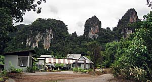
Khao Luang (Mountain) Massive in south Thailand is part of a national park since 1974. A great number of seldom or even unique species find a refuge here. The numerous peaks in the area are pretty high, and the different altitudes of the landscape grant different species valuable habitats.
A small family resort in Khao Sok Village near the park's headquarter. Short behind are some of the bizarre limestone mountains who coin the landscapes. Image by Asienreisender, 2009
Khao Sok National Park is the largest national park in south Thailand. It has still a considerable core of primary rainforest. The landscapes are coined by bizarre limestone mountains as they are around in the provinces of Krabi, Trang and Satun, further south. Tragically there was an artificial lake queued in 1982 which means a heavy impact for the nature (Chewo Lan Lake). But it's still a great landscape to stay for a time in the nature and watch many animals and plants. Khao Sok National Park is no touristic mass destination.
Kirirom National Park spans over a unique landscape in south Cambodia. A high plateau above 600m altitude, the wide rolling plateau is covered with pine trees (pinus merkusii). The scenery looks somehow mediterranean. The climate is much cooler than down in the tropic plains. But the wonderful nature here is under severe threat and long-term degradation...
Arson, poaching, logging, building sites, more and more roads, more traffic, more people, rubbish, din - that all comes with the ongoing development of Kirirom Mountain in Kirirom National Park.
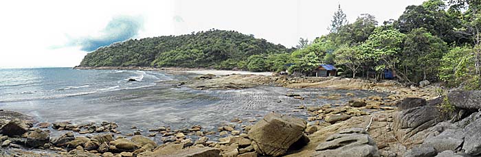
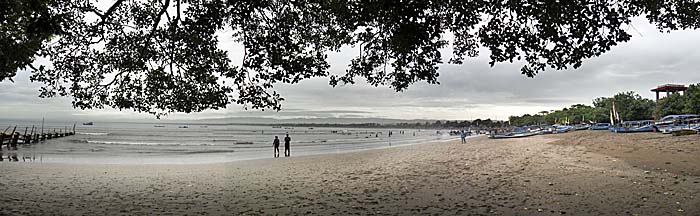
A really quiet and green place for people who are fed up with civilization is Ko Chang in Thailand. The American naturalist Henry David Thoreau (1817-1862) might have enjoyed it to spend some time here. Only a few people live here, and there are no real roads on the island; it's merely a very few rather small concrete pavements.
Ao Tadaeng, the smallest beach and bay on Ko Chang, facing it's western side. Now, in monsoon season, nobody is here. Image by Asienreisender, 2012
Koh Kong / Cambodia
The little border town of Koh Kong is a very remote outpost in Cambodia. It was for a long time very isolated, until only in the last years a road with alltogether five new bridges connected it to inner Cambodia to the east and to Thailand on the other side. The place is situated at the feet of the Cardamom Mountains at the banks of Kah Bpow River at the shores of the Gulf of Thailand. The large province covers much of the large mountains north with Cambodia's last remaining tropical rain forests. The long coasts are mostly overgrown by some of the last vast mangrove forests left in Southeast Asia.
The landscapes of Krabi are among the most impressing in Thailand. Coined by limestone mountains in bizarre shapes who continue as more than hundred islands in the Andaman Sea, there is a wide variety of other habitats as tropical rainforest, mangrove forests seaming the long shores, sand beaches, rivers and swamps. The marine life alone is worth to come here for. For those who know the 1999 movie 'The Beach' will appreciate the scenery on Ko Phi Phi island(s), where the film was made.
Approaching Railay Beach
The double beach on isolated Railay Peninsula is only accessible by boat. Image by Asienreisender, 2010
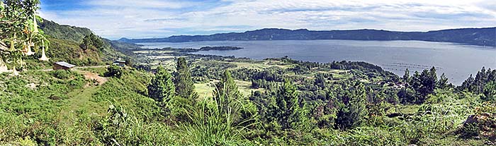
Lake Toba on Sumatra is situated 905 m above sea level. That makes, although being very close to the equator, a very nice, moderate climate. But, above all, it's one of the most dramatic landscapes in Southeast Asia, shaped by the eruption of a former supervolcano 75,000 years ago.
Lake Toba seen from Samosir Island, south of the village of Tomok. Image by Asienreisender, 5/2010
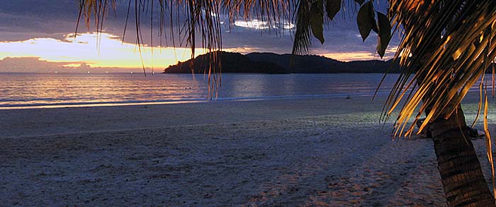
Langkawi Archipelago / Malaysia
The Langkawi Archipelago is a island group of about hundred isles of who Langkawi Island is the biggest. It's one of the major tourist destinations in Southeast Asia with about three million visitors in 2012. Most of the islands are uninhabited, and much of them is covered by tropical rainforest. The whole archipelago has been declared 'World Geo Park' by the UNESCO in 2007.
One of Langkawi's western beaches at sunset. Image by Asienreisender, 1/2010
The Malay Peninsula
The Malay Peninsula is a more than 1,500km long peninsula in the south of the Asian continent between Bangkok and Singapore. It's backbone is the Titiwanga Mountain Chain who form on some parts of the peninsula bizarre shaped limestone peaks. The peninsula was formerly widely covered with tropical rainforest, which is now mostly transformed to rubber plantations, palm oil plantations and other cash crops. The peninsula is also coined by many hundreds of kilometers of sand beaches and mangrove forests.
The Isthmus of Kra
The Isthmus of Kra is the narrowest geographical point of the Malay Peninsula. It's also the border between Burma/Myanmar (right side) and Thailand. Image by Asienreisender, 2012
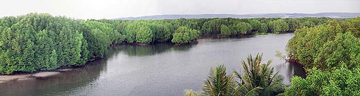
Just a few decades ago most of the long, long coastlines of Southeast Asia were seamed by mangrove forests. Mangrove is a general term for dozends of different trees and bushes who specialized on swampy, saline grounds in tropical and subtropical regions of the earth. They offer a vast habitat for a lot of fish and other species to live and breed in. However, mangrove forests are under attack. Industrialization and urbanization threaten the biotopes heavily. When they are removed, the coasts loose not only much of their biodiversity, but also protection from floods and tsunamis.
A mangrove forest on 'Fishing Island' in the delta of Teuk Chhou River south of Kampot, Cambodia.
Image by Asienreisender, 2013
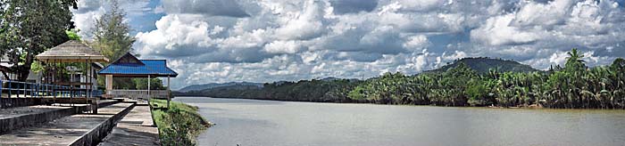
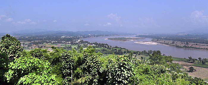
The Mekong River
On the Tibetan plateau in some 5,000m altitude melting waters are gathering and running downwards the mountain slopes, forming streams and rivers. Over the next several thousand kilometers one of them is swelling up to the largest river in Southeast Asia and the one with the second richest biodiversity in the world.
The Mekong River at Chiang Saen, forming the border between Laos (right side) and Thailand (left side).
Image by Asienreisender, 10/2011
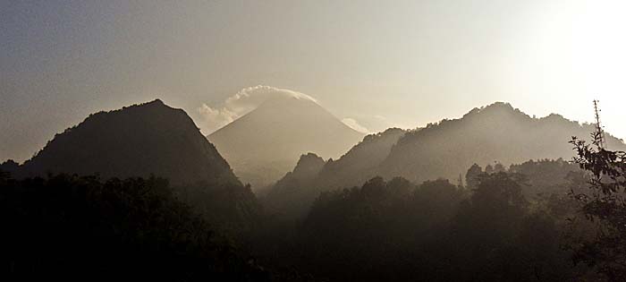
Mount Merapi / Java
Indonesia is deeply shaped by volcanic activities. It's part of a 40,000 kilometers long stretch of vulcanos, reaching from New Zealand along the Andaman Sea (...) until South America. The volcanic ring of fire is paralleled by earth plates, pressing against each other. Two thirds of the world's active volcanos are along the pacific ring of fire. A great deal of the ring's volcanos and the most active ones are in Indonesia.
Climbing Mount Merapi is an extraordinary experience. The way up offers stunning views around and the sight into the caldera is deeply impressing. Here you get a depiction of the hike up to the top.
Mount Merapi, it's caldera surrounded by smoke, as to see many times. In the foreground is a deep canyon, dry in the dry season, a river on the ground in rainy season. There are other deep and kilometer long canyons around the Merapi. Certainly they have been caused by the tectonic activities. Image by Asienreisender, 2012
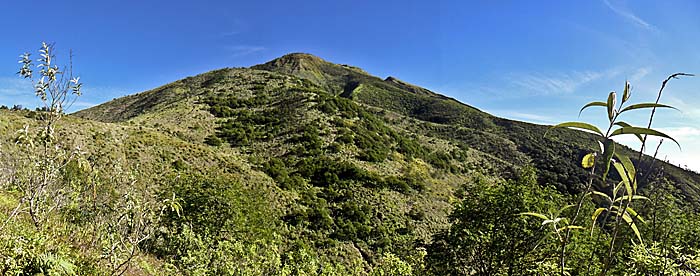
Climbing Mount Merbabu / Java
The famous firemountain Merapi has a close neighbour. When being in Selo for having a climb up the Merapi it's worth to stay another day and climb the Merbabu as well. Although far not as spectacular as it's celebrity neighbour, it offers great views on the Merapi as well as to the northern and eastern directions.
After more than an hour walking one leaves the forest and has a first glance around. There are four peaks to see on the image. The one in the foreground is a very small one. Having a very close look one can recognize three others behind. It's still a long way up to the top. Image by Asienreisender, 2012
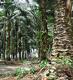
Palm Oil Plantations
The landscapes of Southeast Asia are changing rapidly. The native tropical rainforests get logged and destroyed for huge monocultures. The demand for palm oil products on the world market is rapidly rising, and to cover that, palm oil plantations are getting massively expanded. In the west the destruction is often called 'ecological'. However, all the greenwashing of palm oil and it's products is mere fraud.
Pangandaran, actually a town at the south coast of Java, also covers a peninsula with a pretty tourist beach on it's western coast. It's white sand and invites for longer walks along the coastline, and the open air restaurants make it a pleasant place to have some food or a cool drink.
Moreover, there is a nature park at the tip of the peninsula, whith one of the last patches of tropical rainforest left on the heavily overpopulated island of Java.
Pangandaran's west coast with the kilometer long beaches. Image by Asienreisender 5/2012
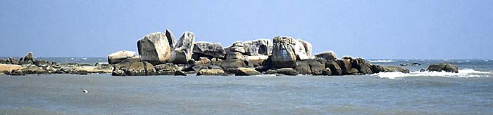
Pangkor Island / Malaysia
Pangkor, on the western shores of Malaysia, is mostly covered with tropical rainforest, of which a good part is still primary. That's why there are so many species living on Pangkor: eagles, monitor lizards, otters, two kinds of hornbills, wild pigs, macaques, seasonal big turtles, laying eggs at Pangkor's coast, a great deal of snakes, many cats, some dogs, and, of course, not few mosquitoes. If you are very lucky, you can see a sliding lizard 'flying' from one tree to another in the jungle.
Typical for the long west cost of Malaysia and further in the north, along the Andaman coast, are these huge rocks and their formations. Image by Asienreisender, 7/2012
The Phetchabun Mountain Range | Pasak Valley / Thailand
The Phetchabun Mountains are a double mountain range in the lower north of Thailand. The ranges run in north-south direction and are separated by the alluvial plain of the Pasak Valley. The hilly and mountainous landscapes are covered by larger deciduous monsoon forests. They separate the Khorat Plateau from the Chao Phraya plains in central Thailand. Some National Parks like Tat Mok, Nam Nao and Thung Salaeng Luang promise some protection for the fragile remaining nature.
Pasak Valley measures roughly about 15km in width. It's grounds are consisting of fertile soils, much of it heavy clay. In the valley lies Phetchabun town, a province capital, and some smaller places like Lom Sak and the historical site of Si Thep. Apart from the urbanization it's completely used for agriculture. The valley with it's many streams from the mountains and the plenty of rain in the rainy season is drained by a net of rivers of who the Pasak River is the central one who unites them all.
Dong Paya Yen, the eastern range of the Phetchabun Mountains. The western range is called Khao Lang Non Son. Image by Asienreisender, 6/2017
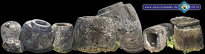
The Plain of Jars / Laos
The Plain of Jars is home to some of the oldest and most mysterious archeological sites in Southeast Asia. It's a huge landscape of 5,500 km2 on a high plateau in northeast Laos. 85 sites with thousands of megalithic stone jars (urns) are irregularly spread over the countryside, showing no pattern of alignment whatsoever. The ancient culture dates at least 2,000 years back, maybe much longer. Exploration is aggravated by millions of unexploded ordnance (UXO) from the American Vietnam War. What was the meaning of all these many jars?
Enigmatic Jars around Phonsavan...
Read the article on the mysterious 'Plain of Jars'...
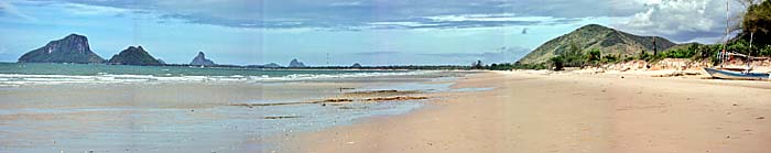
Prachuap Khiri Khan / Thailand
T
he Malay Peninsula at Prachuap Khiri Khan is coined by long sand beaches and coconut plantations. Further apart from the coastline the terrain elevates into the Tenasserim Mountains. Remarkable are huge stone rocks who give the surroundings often an archaic look. Towards the mountains large pineapple plantations stretch out. Through the mountains runs the Thai/Burmese/Myanmar border. Prachuap Khiri Khan marks the narrowest part of Thai territory - Thailand is merely 11km wide here.
To both sides Prachuap Khiri Khan is flanked by many kilometer long sand beaches. Here a scenery north of town. Image by Asienreisender, 2010
Rabbit Island - Koh Tonsay / Cambodia
Rabbit Island (also: Koh Tonsay) is one of the few touristic Cambodian islands in the Gulf of Thailand. It's a short trip from Kep to nearby Rabbit Island by boat and, over the week, a calm place to relax, to swim and snorkel and to enjoy the surrounding nature. The west beach offers stunning views towards Bokor Mountain and the coast of Kep as well as to the big Vietnamese island of Phu Quoc.
This panorama picture includes an angle of about 180 degree. At the right side the Andaman Sea is visible, while at the left part the mountain chain appears Image by Asienreisender, 10/2012
Ratanakiri / Cambodia
The northeastern province of Cambodia, bordering Vietnam and Laos is widely covered with tropical rainforest. It is one of the last refuges of the Cambodian rainforests and for many animal species. Among them are allegedly wild elephants, gibbons and tigers who still live in the remotest parts of the jungle. The biodiversity here is or, as one has to say now, was among the richest in Southeast Asia.
Ratanakiri's rainforests are shrinking considerably and are replaced by huge monocultures of rubber and cashew nut plantations. The indigenous people suffer a sad fate therefore. Image by Asienreisender, 4/2013
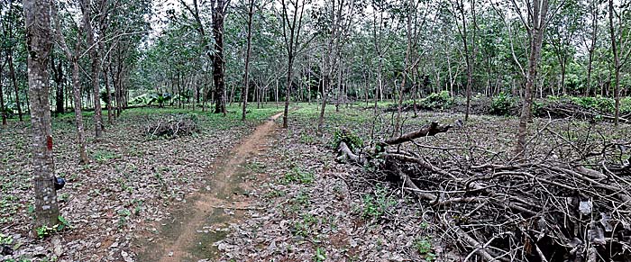
Rubber Plantations
The contemporary landscapes of Southeast Asia are undergoing a rapid change. That is not only due to a rampant urbanization and the deforestation of the tropical rainforests alone. An increasing part of the land mass is transferred into palmoil and rubber plantations. Both agricultural industries serve the hunger of mostly the automobile industries. In 2010 lobbyists announced that the number of global vehicles will be doubled within the next 15 years, until 2025. That makes rubber and palmoil increasingly needed resources for the future.
Ko Chang, as much of the south of Thailand, is coined by rubber economy. Image by Asienreisender, 9/2012
4000 Islands (Si Phan Don) / Laos
Some 120km south of Pakse in Laos the Mekong River has it's broadest part on his 4,800km journey from the high Tibetian Plateau down to the South China Sea. Here the stream becomes 14km wide and splits up in many sidearms. A great number of islands appear here in the big river. The section is called the '4000 Islands' and stretches out over a length of 50km. It's one of the natural wonders of Southeast Asia.
Right side: Samphamit Waterfall, one of the Mekong Falls (Khone Falls) at the 4000 Islands. Image by Asienreisender, 2013
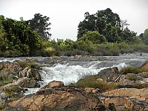
The natural monument of Stung Phong Roul Waterfall is exposing the sandstone of which the mountain (at least partially) consists. Now, in April, the hottest and driest time in the year, the river is almost fallen dry. But that's not the whole reason for it; not far stream upwards is a hydropower dam queueing the water. Dams have a huge impact on the natural surroundings.
The waterfall is altogether about 50m deep. Image by Asienreisender, 4/2015
Tenasserim Mountain Range
The Tenasserim Mountains are a more than 1,500 kilometers long mountain chain which marks over roughly 500km the border between Thailand and Burma/Myanmar. It's an offspring of the Himalayas, but older than this largest mountain massive on earth. Alltogether do the Tenasserim Mountains stretch from the Three Pagodas Pass at Sangkhlaburi all the way down to Singapore. Insofar, these mountain formation is the backbone of the Malay Peninsula. The material of the mountains is dominantly granite.
In the south, the mountain chain continues at Phattalung and deep into peninsular Malaysia (see: The Cameron Highlands) as Titiwangsa Chain. However, the Titiwangsa Mountains are a part of the Tenasserim Mountains. North of the Three Pagodas Pass, another mountain chain continues northwards, forming the border between Thailand and Burma/Myanmar; it's the Dawna Range. The highest peaks are Mount Tahan and Mount Korbu (Gunung Tahan, 2,187m and Gunung Korbu, 2,183m) in Malaysia. In the northern part, Mount Myinmoletkat Taung with 2,072m is the highest point, situated in Burma/Myanmar. In the middle section, Khao Luang (1,835m) in Nakhon Si Thammarat is the highest peak. The western slopes get much more water than the eastern slopes, for the southwest monsoon brings much more rain than the northeast monsoon.
The mountainous border region between the two countries is still remote, sparsely populated and widely covered with tropical rainforest. That does not mean the nature would be intact; it's under severe and growing pressure. Nevertheless, still there are many animals and plants living who are rare and endangered. Among them are allegedly about a hundred tigers and some hundred wild elephants. The Sumatran Rhinoceros has been repeatedly seen in the northern section of the chain in former decades, but I doubt it's still surviving there.
The River Kwai (actually Khwae Yai River) is winding through fertile landscapes in the Tenasserim Mountain Chain in Kanchanaburi Province/Thailand. The river results of the confluence of a number of smaller tributaries around the Three Pagodas Pass. Nowadays, the source region of the river is transformed into an artificial lake, Khao Laew Reservoir, by Vajiralongkorn dam. Image by Asienreisender, 10/2006
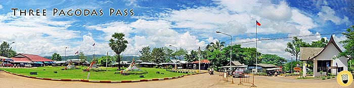
The Three Pagodas Pass
The pass in the Tenasserim Mountains at the border of Thailand and Burma/Myanmar served since many centuries, rather millenias as one of the few connections between the Salween catchment area and the fertile plains of the Chao Phraya River. The first people who came from India to the coasts of the Gulf of Thailand over the land route used this connection, since there was practically little of an alternative to the Three Pagodas Pass. From the beginning of the Dvaravati Culture on, probably already since long before, the pass served as a crucial part of a long trade route, connecting India with parts of China. A succession of Burmese armies crossed the pass, among those who captured Ayutthaya in 1569 CE and destroyed it totally to the ground in 1767 CE.
In the 20th century the infamous Thailand-Burma Railway (the 'Death Railway') was built through the Three Pagodas Pass. After the Second World War the railway got destructed; only in the very recent years the small, remote border point is getting revived for the sake of the growing Thailand/Burma trade.
The comparably small three pagodas in the left part of the picture are centuries old. It's believed that they have been built as a symbol of peace, as a counterpower to the martial past of this part of the Thailand-Burma route. Image by Asienreisender, 10/2006
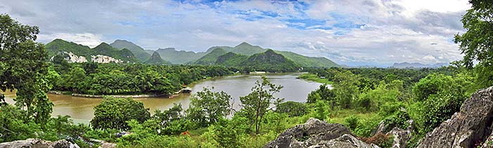
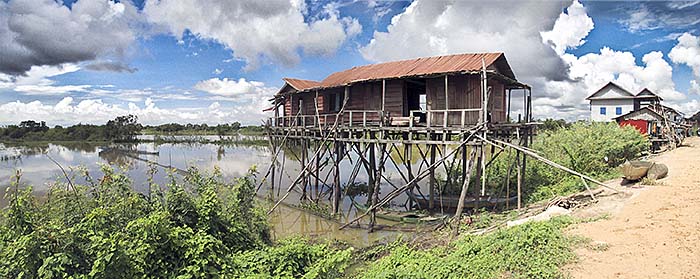
Tonle Sap Lake | River / Cambodia
Tonle Sap Lake is the largest freshwater lake in Southeast Asia. It's home for a great biodiversity. The great lake is connected to the Mekong River by the Tonle Sap River. There is a unique phenomenon going on with this habitate. Twice a year, in the monsoonal rythm, the river is changing it's direction, either draining the lake into the Mekong River or draining water from the Mekong into the lake.
About 1.2 million people live along the lake's shore. They adapt to the annual floods with building stilt houses or even flooding villages, houses who swim in the lake and can change their location. The population is rapidly growing. Image by Asienreisender, 9/2015
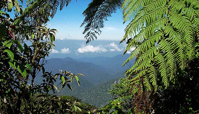
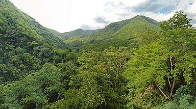
Tropical Rainforest
For somebody unexperienced the jungle is quite a mess. Civilized people are used to straight lines, buildings, roads, asphalt, concret and many other people around. In other words to a completely artificial environment. The jungle therefore provides nothing a civilized man is used to.