The Mekong River is by far the most remarkable and important river in whole Southeast Asia. He is home for an huge wildlife and flora and feeds 65 million people. He runs through six different countries, if you don't count Tibet as a separate country. The Mekong is running all the way down from the Himalayan Plateau into the South China Sea.
The Mekong Delta was also the birthplace of the first Southeast Asian civilization, Funan. The great sweetwater lake Tonle Sap, the by distance biggest lake in Southeast Asia, is part of the Mekong River system. It was providing the food source for the biggest and mightiest empire of the world region: Angkor.
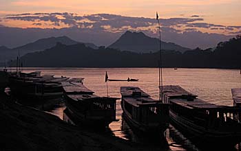
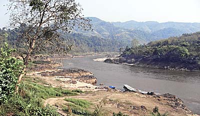
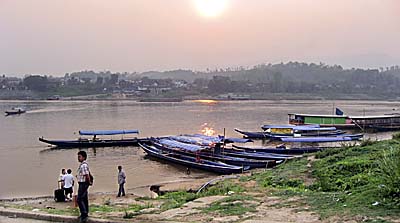
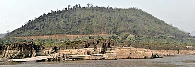
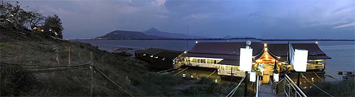
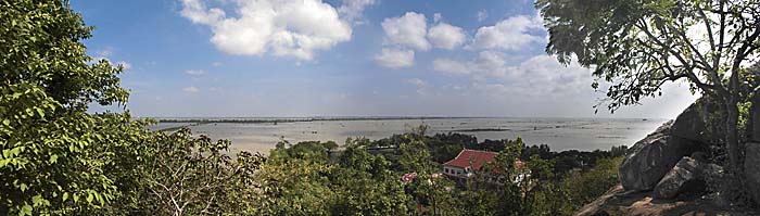
The Mekong at Luang Prabang
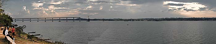
Nightfall at the riverbanks at Luang Prabang. The river boats commute between Vientiane and the places Chiang Khong, Houayxay, Chiang Saen and, partially up to Xieng Kok and further into China, behind the 'Green Triangle'. Image by Asienreisender, 2006
The Mekong River hosts also the second largest biodiversity of a river on earth. Only the Amazon river has a richer biodiversity.
The different people along it's banks have given different names to the river. 'Mae Nam Khong' is Thai / Laotion and means 'Mother River Khong', short: 'Mae Khong' or just 'Mekong'. The Khmer People in Cambodia call the river similar, sometimes 'Tonle Mekong'. In China it's called 'Lancang', and in Vietnam 'Song Me Kong'.
The Mekong River is counted among the eleven biggest rivers in the world. The question is now, 'what makes a river big?' Is it the length? The water volume? The biodiversity? The catchment area? Or a sophisticated combination of a number of factors?
However, it's a matter of fact that the Mekong River is the longest river in Southeast Asia and in the greater Mekong subregion are 320 million people living. At least 170 deep water pools are in the Mekong in Laos and Cambodia alone. Some of them have a depth of 80m.
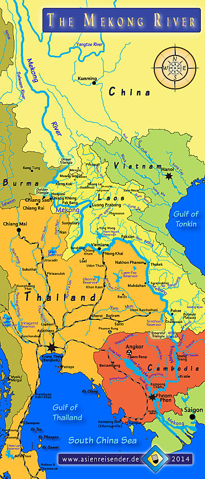
The Course of the Mekong River
On the Tibetan Plateau in some 5,000m altitude, melting glacial waters are running downwards the mountain slopes, forming streams and rivers. Some of them grow to become major rivers. Here, at the eastern slopes, source the Yangze River, the biggest river in China, the Yellow River, the Salween, who is crossing whole Burma, and another one, who becomes the Mekong River. There is no particular spring known as the origin of the Mekong.
The upper Mekong in Tibet and China, called 'Lancang', stretches for some 2,000km down to the Green Triangle, a three-country touching point of China, Burma and Laos. The Lancang is coined by high surrounding mountains, deep valleys and fast currents. It's an icy mountain river up there and by far not as wide as it later becomes.
The Course of the Mekong
A map of the Mekong River's course. For an enlarged, interactive map go here!
Leaving China, the Mekong forms for some 200km the border between Burma / Myanmar and Laos, until it reaches the Golden Triangle, another three country border point meeting Burma, Laos and Thailand. From there the river flows another 2,600km until it reaches the South China Sea in south Vietnam. That makes an overall length of 4,800km.
At the Golden Triangle the river begins to forms the country border between Laos and Thailand. A few kilometers behind Chiang Khong the river's course leads into Laotian territory. The part between the Golden Triangle and Luang Prabang is still typified by a mountainous surrounding, gorges and rocks in the river, but by far not as wild anymore as it is in China. Whirls and streams make it difficult to navigate boats and ships. From Luang Prabang on the river gets wider and is better navigable for bigger ships. A few kilometers south of Sanyabury in Laos the mighty river leaves the mountainous parts of Laos and enters the plains. Here the river grows ever bigger and forms from Sanakham on again the border between Laos and Thailand.
The height of the water level can vary between rainy season and dry season by 10m to 15m.
Forming the state border between Laos and Thailand, the river itself and it's islands belong to Laos, apart from a stripe of 15m on the Thai side. Further south, about where the also large Mun River in Thailand's Isan joins the Mekong, the big river again turns into Laotian territory, passing Pakse and entering Cambodia hard behind the 4000 Islands (Si Phan Don).
At Phnom Penh, Cambodia's capital, three rivers come together and form a kind of cross. The Tonle Sap River joins the Mekong River. In fact, they are a common river- and ecosystem. While the Tonle Sap River is draining the big Southeast Asian Tonle Sap Lake in dry season, in rainy season (southwest monsoon), the water in the lower Mekong system can not drain quickly enough towards the sea and curiously water is pressed riverupwards into the Tonle Sap River and into the Tonle Sap Lake.
At Phnom Penh the Mekong also splits up into the Mekong itself and a parallel river, the Bassac, who both lead downstream into the South China Sea south of Saigon (Ho Chi Minh City).
In south Vietnam the Mekong finally splits up in nine main arms and many more smaller side arms, forming the mouth of the Mekong. Due to the nine main arms the Vietnamese call the river there sometimes the 'nine dragon river'. Here the Mekong is particularly important for the watering of huge areas of agricultural land, before it flows into the South China Sea. An extensive canal system has been built at the Mekong delta and is operated since centuries. In fact, the history of the canal system reaches back to the times of Funan, the first civilization in Southeast Asia, which emerged in the Mekong delta.
On the Tibetan Plateau
The Tibetan Plateau (also: Himalayan Plateau) is a huge elevated plateau in central Asia. It's situated mostly in Tibet, parts of China and India. With a size of roughly 2,500,000km2 it's five times as big as Thailand. Since the Tibetan Plateau is not only the largest, but also the highest plateau on the globe, it's often called 'the roof of the world'.
The Decline of the Tibetian Glaciers
Icy waters melt down from the eastern edges of the Tibetan Plateau and form streams, brooks, rivers. One of them becomes the Mekong River.
Things are changing, though. Due to global warming the glaciers loose substance. The glaciers who feed the Mekong River loose annually 8% of their ice caps. Serious scientific estimations from different institutions predict a complete loss of all the glaciers on the Tibetan Plateau from 2035 on (Milton Osborne, 'The Mekong', 2009). Sketch by Asienreisender, 2014
On and particularly at the edges of the Tibetan plateau stretches a gigantic, magnificent glacier world with ten of thousands of peaks. The southern mountain range of the plateau is the Himalayan Range. There is so much water piled up here in form of ice, that it is seen figuratively as a 'third pole'. However, glaciers are not static. They are icy, frozen streams of water, who move slowly downwards the steep slopes and mountain valleys until they reach altitudes where it's getting warmer. The ice is melting and forming many streams as the sources of all the big rivers around.
In the eastern and southeastern edges of the Tibetan Plateau the magnificient mountains of the region form the steep slopes, deep gorges and high peaks of the Hengduan Mountains. In the southwestern part of the Hengduan Mountains the three great Asian rivers Yangtze (Jinsha), Mekong (Lancang) and Salween (Nujiang) have their origins. A bit further north the source of the Yellow River forms another big stream, but it flows into eastern directions. A fifth big river sourcing in the same region is the Irrawaddy River who is flowing later through whole Burma / Myanmar.
The landscapes still in the Tibetan Plateau, around the headwaters of the Yellow River, the Yangtze and the Mekong River, are officially under protection as the Sanjiangyuan Nature Reserve (also: Three Rivers Nature Reserve, what can easily be mixed up with the 'Three Parallel Rivers of Yunnan Protected Areas', a UNESCO World Heritage further south - see below).
Glaciers are Streams of Ice
A glacier is a stream of ice which behaves similarly to a river, but in very slow motion. The ice's origin is compressed snow which can not melt in the permafrost environment. But, accumulating ever more, under growing pressure it finds a way downwards the mountain slopes and valleys.
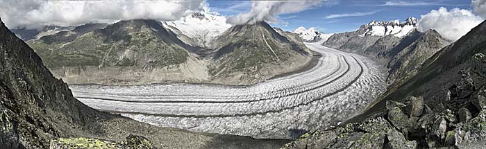
In lack of an own photo of the glaciers on the Tibetan Plateau this one shows the Aletsch Glacier (Aletschgletscher) in Switzerland. It's 23km long and moving 180m per year. Image by Asienreisender, 2007
Waves of Ice
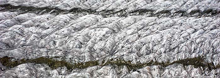
A closer look on the surface of the glacier shows a structure similar to waves on a water's surface. As in river water there are also defilements as dust and other fallout to see. Image by Asienreisender, 2007
Lancang
Yunnan, a southern province of China, is bordering the Tibetan mountains in the west, Burma, Laos and Vietnam in the south. It's by 90% a mountainous region, coined by mountain chains who run roughly in north-south direction. Some of the mountain peaks in the north of Yunnan still reach a considerable altitude of more than 5,000m.
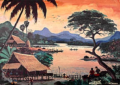
Nomadic Life
The whole upper section of the Lancang River and much of the middle section of the Mekong River is part of Zomia, a huge geographical area inhabited by hundreds of different hill tribes. Painting seen in Vang Vieng. Image by Asienreisender, 2011
The easter part of Yunnan is also part of the Tibetan Plateau. The upper Yangtze, the Salween and the Mekong River run parallel for 300km in different mountain valleys in this gigantic mountain scenery. Though, the upper Mekong River is here called 'Lancang River'. Alltogether the upper Mekong runs for more than 2,000km through China, before leaving it at the Green Triangle.
The surrounding area of where these three rivers run parallel for some 300km from north to south is under UNESCO World Natural Heritage protection since 2003 ('Three Parallel Rivers of Yunnan Protected Areas'). The wider area with it's vertically shaped landscapes is home for a vast and unique wildlife and flora.
The protection status didn't stop the industries from hurting the Lancang River (upper Mekong) by building a number of dams. Seven dams are already operating, and twenty more are under constuction, respectively in planning. Additionally the river is partly channeled. The dam construction means a huge impact on the river's constitution and biology. Further downstream in Thailand, since many years people oppose the construction of the dams in Yunnan, but nothing can stop Chinese investment from continuing.
It's also known that systematical rock blasting was done in the years before 2009 to make the river navigable for Chinese freighters from south Yunnan to Chiang Saen in Thailand.
Yunnan is still relatively sparsely populated. Many of the inhabitants are ethnic minorities of the so called 'hill tribes' or hill people. Some of the same tribes are living in the mountains around the Golden Triangle in Burma, Thailand and Laos as well.
Between the Green and the Golden Triangle
After the Lancang River leaves China it get's another name which is much better known: from the three-countries-point of the Green Triangle the Mekong River marks the state border between Burma / Myanmar in the west and Laos in the east. The surroundings are still mountainous with steep slopes and gorges, but it's far no more that high and wild as it is at the upper Mekong.
Along the Upper Mekong
The Mekong River at Xieng Kok, a small village in Laos. The other side of the river is Burmese territory. Drug gang territory. People sometimes 'disappear' here. Image by Asienreisender, 2010
This region is since the 1970s widely known as the notorious (wider) 'Golden Triangle', and became world famous for being the largest opium and heroin producing area in the world. Although there is a radical anti-drug policy in Thailand and opium production almost completely ceased in north Thailand, it's still thriving in Laos and particularly Burma / Myanmar. Nowadays grand-size metamphetamin production takes place here as well, overcoming the 'old-fashion' opium production. Mighty drug lords with powerful private armies control most of the territory west of the river and make a lot of money. Shootings, robbery and raids happen on this section still today as they might have happend in the old times. This matter of fact was ironically an important barrier for the development of the region. From a protective point of view, it saved the Mekong from further industrialization. This era seems to come to an end. Reports from recent years describe an increasing construction activity at the Mekong River between the Green Triangle and the Golden Triangle.
When the magnificent river then reaches the next three-country-point, the Golden Triangle, what is the touching-point of Burma / Myanmar, Laos and Thailand then, there is already a great attraction erected on one of the river's big islands: it's one of the so very much beloved Chinese casinos.
At the Golden Triangle the Ruak River, which forms the border between Thailand and Burma / Myanmar between here and Mae Sai / Tachileik, joins the Mekong.
The Mekong between the Golden Triangle and Chiang Khong
I personally know the river section between the Golden Triangle and Chiang Khong/Houayxay since 2007. The road along the riverbanks, it's about sixty kilometers, is among the most picturesque roads I have ever seen. A small road with potholes and little traffic, mountains, and here and there a small village. That's at least what it was at the beginning of my observations until recently.
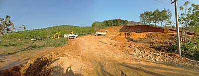
Rampant Building Activities
One of many building sites along the road between Chiang Khong and the Golden Triangle. In the background plantation monocultures; the virgin forests have gone decades before. Image by Asienreisender, 2013
Due to the massive economic growth in the Southeast Asian world region there is permanent construction activity. The construction and the automobile sectors are capitalistic key sectors for any modern economy. In Thailand and the neighbouring countries the traffic growth is enormous (see also: Traffic in Thailand). Every year millions of cars are blown out onto the streets. It's coming together with the cement industries who are employed to build a number of big projects, particularly highways and bigger roads, but also the new river port at Chiang Saen, the new Mekong Bridge at Chiang Khong/Houayxay and huge areas with terraced houses and now also big river dams. Besides there are many building sites right and left of the parallel road to the river where are new business buildings, stores, temples, administration buildings or private houses are built. Over times I passed on this road every fortnight in 2011 and 2012, and every time I came along I saw more and new building activities. That's so on the Thai side of the Mekong River as well as I see it on the Laotian side.
At the time, April 2016, the road between Chiang Khong and Chiang Saen is getting widened and becomes a four-lane highway.
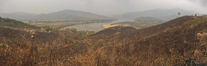
The upper image shows the place on March 2nd, 2007. The hills vegetation is ruined by slash-and-burn, the air is heavily polluted. Many animals have been killed in the fire. March and more April are the peak of dry season. When rain starts again in May until August / September, the burning is no more possible and the dirt get washed out of the air.
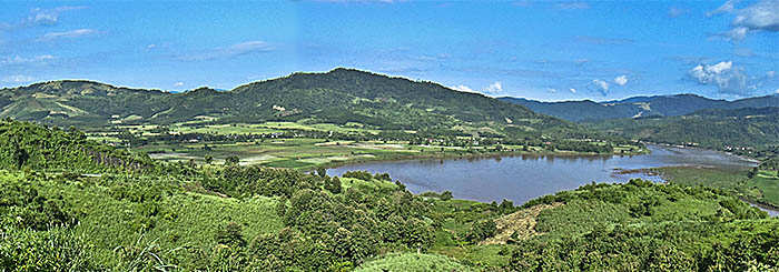
The second image shows exactly the same scenery and has been made on October 29th, 2011. In the meantime the vegetation recovered and formed a savannah. Both images by Asienreisender
Observing the river over long afternoons makes me see growing activities on it. More and more boats are passing by. Bigger building sites appear and change the green river banks into ugly concrete slopes. Only one out of many bad examples is the huge casino construction at the Golden Triangle with a number of additional buildings.
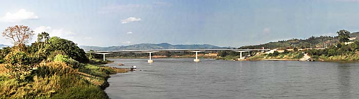
Meanwhile, in July 2013, the 4th Thai/Laos Friendship Bridge opened, linking Chiang Khong/Thailand and Houayxay/Laos. It's the trade link for the big traffic between Kunming, Yunnan, south China and Thailand. Again more traffic will boost, far more trucks than now together with more private cars. Chinese tourism is on the rise in the states where the Mekong is passing through. There are already many cars with Chinese number plates in Chiang Khong. That is certainly just the beginning. There will be more growth, means more, more, more - more of everything. Most of it is pollution.
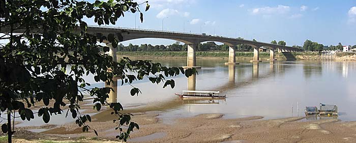
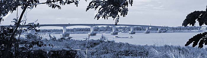
The Mekong River Bridge at Chiang Khong
The 4th Thai/Laos Friendship bridge over the Mekong River, five kilometers south of Chiang Khong. On both sides of the river new bridgeheads are under construction, a lot of concrete is getting piled up here. Image by Asienreisender, 2/2013
The industrialization and economic growth meets a population which has no sense for environmental concerns. The People of Thailand and Laos litter, waste and burn as much as they can. The surroundings of the river suffered deforestation here already decades ago. Agriculture comes with fertilizers and chemicals. Much of it runs into the river. All the waste water of the towns and villages is drained directly into the stream, without being filtered.
Air Pollution
The Mekong at Houayxay. On the other side is Chiang Khong. The strange colours appeared due to massive air pollution, which reaches it's peak in April, before the rainy season starts. Image by Asienreisender, 4/2010
Overfishing is a big issue. The villagers take out of the river as much as they can. If they don't eat the fish themselves, they sell it on the markets. The Giant Catfish, which once appeared in a great number, was a few years ago still living here, but is now only history.
There are already seven dams installed at the upper Mekong in China. They have an impact on the water flow. Mekong water in China is e.g. used for irrigation. This water is no more flowing down. Sometimes there is so much water taken out, that the river level downstream falls considerably down. In other times there is much rain at the Lancang and suddenly the dams floodgates are opened and flood the river. Then the water level rises quite suddenly and the river gardens in the Chiang Saen / Chiang Khong region are flooded. It happens that the water level rises or falls for two meters in a single day. There are claims that the dam operators flood the river before certain transport ships sail down from there, to make the river better navigable for them. The Chinese dam operators seemingly don't announce the authorities in the countries downstream before what they will do soon.
The Sanyabury Dam and all the dams who will follow will have the greatest impact also for the river section here. I dedicated a whole article on 'Damming the Mekong', because that is the biggest issue on the Mekong now.
The Mekong River a few kilometers north of Chiang Khong. The boulders make great hideouts for many species. For a shippingroute therefore they are a barrier and might be blasted in the future.
Until now the section between south China (Yunnan) and the Chiang Saen port are cleared. There is frequent cargo transport and one can watch the workers emptying the wooden transport ships in Chiang Saen. Plans are in the drawer to expand the clearance down to Luang Prabang. Image by Asienreisender, 2013
The above depicted observations I did at the Mekong River section between Chiang Khong and Chiang Saen in the years 2007 to 2013 are, as to expect, not an isolated phenomenon.
A Bridge Construction Site
The construction site of the new bridge over the Mekong River at Ban Pak Beng. On the photo is only a part of the site to see, it's much bigger; the part at the left side of the river is covered. The bridge will connect Oudomxay with Muang Ngoen at the Thai border at Nan Province. The picture looks so blurry because there is an apocalyptic amount of smoke in the air. Image by Asienreisender, 3/2013
The rapid development and industrialization of the Mekong River stretches down all the way to at least Ban Pak Beng. Behind Ban Pak Beng it seems for a bigger distance that there were at least no bigger changes, but long before approaching Luang Prabang the Mekong River banks are again under an urbanization process.
What appeared like 19th century landscapes just 20 month ago (compare with 'On the Mekong', a river journey done in July 2011) is now more and more punctuated with building sites on both sides of the mighty river. Everywhere in the green hills and mountains are traces of slash and burn, big building sites, road constructions. New parallel roads over many kilometers on both sides of the river appeared in the few months. On the river itself are new houseboats with karaoke entertainment and restaurants. A bit riverupwards of Ban Pak Beng is a new bridge under construction. It's a big building site as well.
A New Road
New road construction activities in the mountains next to the river over many kilometers. Image by Asienreisender, 2013
River traffic has increased clearly. More boats of different kinds are on the river. The amount of litter, mostly plastic, increased as well. Chemicals and other liquids poured into the stream are invisible, but certainly not absent.
Watching the forests to the right and left of the river, it's clearly to see that there is only secondary forest left. The closeness to the river made it easy to cut and transport the old, big trunks. A lot of slash and burn happened as well, where the forest has been replaced by small fields for vegetables, corn or rice paddies. At other spots appear teak plantations instead of the former primary rainforest.
For getting a lively impression of how the Mekong and it's surrounding looked at this part of the river in July 2011, I again recommend to watch the video 'On the Mekong'.
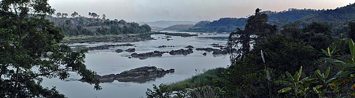
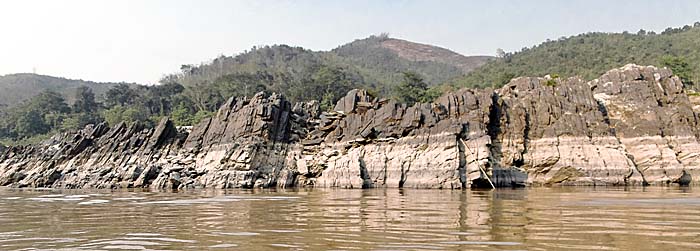
Rock Formations in the Mekong River
A great variety of rock and stone sedimentation appears along the river's course. Particularly in dry season many rocky islands grow out of the water. This is just one example of many various rock formations who appear at many spots. These rocks make the navigation on the river also quite risky. Rock tips close below the water level are difficult to recognize for the skipper. Image by Asienreisender, 3/2013
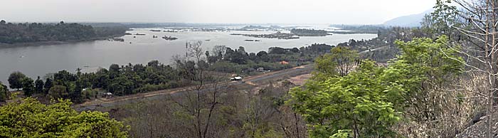
Growing Wide - The Middle Section of the Mekong River
Just a couple of years ago the Mekong was still the main traffic route between Luang Prabang, situated in north Laos' mountains, and the country's capital Vientiane. The old road connection was in a very bad shape and not safe - the civil war was still going on in the mountains and forests. In 2006 the buses were always accompanied by at least one man armed with a rifle, to protect the bus in case of a raid. In the last years the situation changed. The government troops won the civil war against the Hmong People and the road got improved.
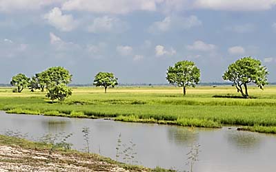
A Mountain Tributary
The Nam Khan River in the mountainous scenery at Luang Prabang. The Nam Khan is a tributary of the Mekong River. Image by Asienreisender, 2006
Now the traffic on the road is increasing while the ships mainly ceased to sail the Mekong at this section. That is partially so because the river at this section is difficult to navigate, strong currents in the rainy season and infrequently new appearing sand banks in the dry season made it risky to use the waterway.
Besides there is a grand-size building site for a new megadam at Sanyabury. The Sanyabury dam is the most controversian building site in Southeast Asia. Access to the construction site is prohibited. The dam is very much under critic from the concerned people who live in the catchment area of the stream, and the Mekong River Commission for it's impact on the ecology of the river and it's wider surroundings. Obviously the investors, who build the dam in agreement with the Laotian government, broke the committment to do that only in agreement with the Mekong River Commission. Although there was a moratorium for the site decided, the construction activities went secretly on. Witnesses are therefore not wanted. In early 2014, official announcements said that the dam construction is completed by 23%. It's full completition will expectedly be in 2019. From 2015 on a severe impact on the river's fish population is to expect, threatening the food sources of millions of people.
Waiting for the Ferry
On the road from Luang Prabang to Sanyabury. The bus is waiting for the Mekong ferry. Image by Asienreisender, 2011
Sanyabury itself is a province capital which, as a town, is not directly situated at the river banks but some kilometers west of it. Sanyabury lies in a river valley, separated to Thailand at the west by a mountain chain as well as to the east by another mountain chain, what makes it quite an isolated place. There is only one road connecting Sanyabury with Luang Prabang and Vientiane. The mountain chains as well as the long-stretched valley between them with the meanwhile mighty and wide Mekong River is running in a north-south direction. Somewhat downstream of Sanyabury the mountains slowly run out in huge plains.
The route from Luang Prabang via Sanyabury, Pak Lai and Sanakham is a great alternative to reach Vientiane. It's completely off the beaten track and very few Westerners or tourists in general come here. Therefore the transport is sparsely, but all of the bigger villages provide simple accommodation. Hitch-hiking is sometimes required, but not too easy in Laos.
At Sanakham the magnificient river again touches Thailand and forms from here on the border between the both countries for several hundred kilometers, until shortly south of Pakse, where it enters Laos again. At Sanakham the Mekong's flow turns to the east.
Vientiane's River Promenade
The Mekong River Promenade at Vientiane. The shot above from 11/2006 shows the old condition when the river banks were in a natural state of affair, the ground of soil and grass, bushes and trees growing there. Simple outdoor restaurants dotted the river banks.
The shot below shows the same place exactly four years later, in 11/2010. The river banks were artificially widened, land was filled into the river. It's representative, tidy, soulless and ugly now. The whole city is under 'reconstruction'. Images and composition by Asienreisender
Passing Chiang Kham in Loei Province, the Mekong flows along the Laotian capital, Vientiane. Vientiane, a few years ago the sleepiest capital in the world, recently became a hectical mega-building site and get's newly made-up in grand style. The whole river promenade, what was a natural place with banyan trees and a couple of simple food stalls under parasols, has been transformed meanwhile by caterpillars into a soulless promenade with flags and memorials. Land extension has been done into the river. It completely lost it's old charm forever. Big Chinese investment is transforming Vientiane into an ugly, faceless place by the standards of our time.
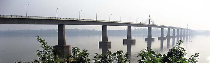
Some twenty kilometers east, the Mekong passes the Thai town Nong Khai with the first bridge over the Mekong, which was built in 1994. Nong Khai also rapidly developed in the last years. There is also a new, long river promenade made and it seems to be a touristic spot for Thai tourists from Bangkok. A number of Westerners settled down here as well.
The Mekong Bridge at Nong Khai
The '1st Thailand - Laos Friendship Bridge' over the Mekong River at Nong Khai. Image by Asienreisender, 11/2006
Now, to the south and later to the west of the river, Thailands northeastern part Isan is stretching out. Isan is widely a flat high plain and always addressed as the poorest part of Thailand. East of the stream the plain continues for a few kilometers. It's fertile land with millions over millions of small rice paddies. In the rainy season the land is green, in the dry season it becomes more and more a yellow-brownish colour, the colour of dry grass and dust. Eastwards, in Laos, another mountain chain is stretching along. It's the Annamite Mountains, who form the border to Vietnam. The mountains make a great panorama seen from Nakhon Phanom west and Thakhek east of the river. Closely north of these two places the third bridge between Thailand and Laos was opened in 2012 (?). A second bridge at Mukdahan 200km south is a few years older.
The Mekong Bridge at Mukdahan
The 2nd 'Thailand - Laos Friendship Bridge' over the Mekong River at Mukdahan. Image by Asienreisender, 2010
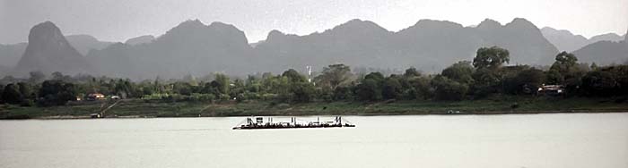
The Mekong Ferry at Nakhon Phanom
The limestone mountain scenery in Laos behind Thakhek, seen from Nakhon Phanom in Thailand. It's zoomed in and looks therefore much closer than it is. The distance to the mountains from Nakhon Phanom is roughly estimated a few dozen kilometers.
In 2011 a 3rd Friendship Bridge opened a few kilometers north of town. Before, the ferry brought all kinds of vehicles, including trucks, over the river. At my last visit, in December 2015, the ferry service was still running, but merely for people and motorbikes. Image by Asienreisender, 2010
The river is now several kilometers wide. At many spots bigger and smaller islands and sandbanks appear. Some of the islands are permanent, but most of them are smaller and disappear in the next rainy season. The water level rises between dry and rainy season up to 15m or more. That makes many housings close to the river banks a precarious place.
A River Scenery
An idyllic scene of people living with the nature. Though, industrialization is entering the scene in large steps. Image by Asienreisender, Pakse, 2013
Shortly after the itself really big Mun River, who runs down from Isan's Khorat Plateau, enters the Mekong River, the stream ceases being the country border and enters Laos. The next big city then is booming Pakse, which has another new Mekong bridge, built with Japanese investment.
Behind Pakse, the remarkable 'Champasak Cultural Landscape' borders the river's flow right hand. It's one of the bigger medieval Khmer sites, a big central temple complex with wider surroundings. In ancient times it was an Angkorian city and there was a road connection to Angkor Thom in the center of the empire of Angkor. In later times Champasak was one of the three Laotian kingdoms in the times before the French occupied the whole region.
The Mekong Bridge at Pakse
A riverboat restaurant in Pakse / Laos. At Pakse the Sedon river from the east joins the Mekong. The riverbanks of both rivers are seamed here with restaurants and karaoke bars. From late afternoon on it's getting incredibly noisy - TAM TAM TAM - BUM BUM BUM - Southeast Asians love it loud.
In the background left there is the illuminated Lao - Nippon bridge to see. Image by Asienreisender, 2013
The Mekong River near Champasak
The Mekong River between Pakse and Champasak. Here it's opening, getting less deep and forming a wide river landscape with plenty of islands and sandbanks. That's how it looks also at some river sections for the next few hundred kilometers downstream in Cambodia. The 4000 Islands are the most prominent island landscape on the whole river's course.
West of the river stretches the mountain chain which is part of 'Champasak Cultural Landscape'. East of the river follows a wider plain which is bordered later by the high Bolaven Plateau. Image by Asienreisender, 2013
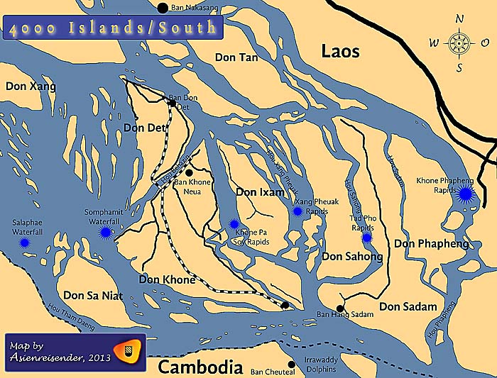
After Champasak the next prominent place on the river's course are Si Phan Don, the 4000 Islands with the Mekong Falls.
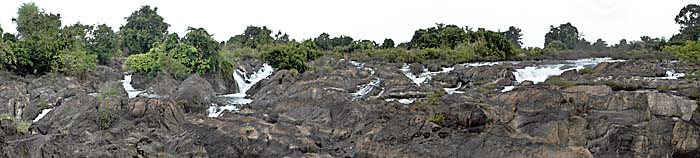
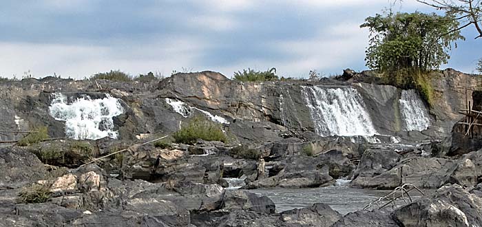
The Mekong Falls / Khone Falls
Some 120km south of Pakse in Laos, the Mekong River has it's broadest part on his 4,800km journey from the high Tibetan Plateau down to the South China Sea. After joining with the Mun River from Thailand, the stream becomes 14km wide and splits up in many sidearms. A great number of islands appear in the big river. The big islands as Don Khong, Don Pet, Don Khone and many others are permanent. But in dry season, when the water level lowers, many more islands, actually merely bigger sandbanks, reach above the water surface. I don't know how many islands there are in dry season, if it is really 4,000 or just a few hundreds I can not tell. But there is a great number of them, and the river looks completely different than it does at other parts. It's divided in many smaller and bigger arms, surrounding all the islands and sandbanks. Plentiful plants grow at the islands banks, providing habitats for many fish species and other animals. Some of the islands are inhabited by peasants and fishermen families. Most of the islands are uninhabited. The whole Mekong River section of the 4000 Islands is approximately 50km long.
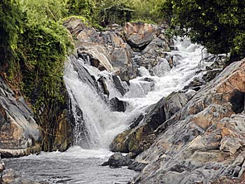
A Mekong Fall
Samphamit Waterfall, one of the two big Mekong Falls west of Don Khone. Image by Asienreisender, 2013
And there is another peculiarity here. The Mekong is 'interrupted' at the Fourthousand Islands in it's equal stream. There are six waterfalls or rapids at the very southern section of the Mekong River in Laos, very close to the Cambodian border. It's the 'Mekong Falls', also called the 'Khone Falls'.
Here the Mekong water drops in cascades over 21m down. The Mekong Waterfalls are the broadest waterfall on earth and the biggest in Asia. Two of the six falls make the main ones: the Somphamit Falls and Khong Phapheng Falls. I think I don't say too much when I call this special landscape with it's great biodiversity one of the great natural wonders of Southeast Asia.
The rapids are very important for the Mekong River. They saved the magnificient and so very rich river in the past from being industrialized in the colonial times already. The French Mekong Expedition (1866) was following the Mekong River upwards to find out if it could be a waterway between the South China Sea and inner China. It couldn't. No ship could pass here.
Samphamit Waterfall
Samphamit Waterfall in most of it's width. That's how it looks in April, at the end of the dry season. In the late rainy season it's a much mightier fall. Image by Asienreisender, 4/2013
The 'Garcerie', one of the first commercial steamboats transported over Don Khone to bypass the Mekong Falls. Image by Asienreisender, 2013
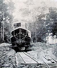
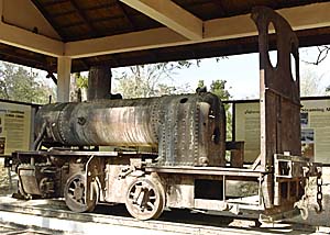
When the French occupied what was before the kingdom of Champasak, respectively part of the empire of Siam in around 1900, they tried to find a solution to navigate the Mekong. Particularly after the 'Paknam Incident' in 1893 the French navy was ambitious to control the middle section of the Mekong River with gunboats. For that purpose a French company built a short railway section on the two islands of Don Khone and Don Pet, linking them with a railway bridge. So they were able to put whole or disassembled gunboats on trains and bypass the rapids.
One of the old locomotives left as a museum piece. It's barely more than a steam engine on wheels. Image by Asienreisender, 2013
How may the future look here for the Mekong River and the waterway? Since there is so much money on the globe, partially in China and Southeast Asia, on the search for investment, it might be that there will be efforts in the future to make the Mekong navigable over the rapids. Technically it wouldn't be a problem. Years ago I visited the 'Schiffshebewerk Niederfinow' in Brandenburg, Germany. In around 1920 there was a big construction finished for lifting ships over a height of 80 meters, connecting two sections of an inland water canal. It still worked fine after almost ninety years. The technical problem here at the Mekong seems to be a much easier one to solve.
For the ecology that would be another hard punch. The construction of the Sanyabury Dam and the dozends of more planned dams on the Mekong and it's tributaries is already the death sentence for a great number of species, including estimated 70% of the fish species.
In late 2013 news spread out that there secretly started a new dam construction at the most vulnerable Don Sahong channel.
The Khone Pha Soi Fall
The Khone Pha Soi Rapids on the easter side of Don Khone. Now they are small, in monsoon they swell on massively. Image by Asienreisender, 2013
The Mekong section at the 4000 Islands is very rich in wildlife. Though, in dry season there are less animals to see than in monsoon. When the rice paddies on the islands dry out, a number of fish populations, who live seasonally in the paddies, are leaving them and migrating into the many Mekong channels. The local peasants have methods to catch part of them.
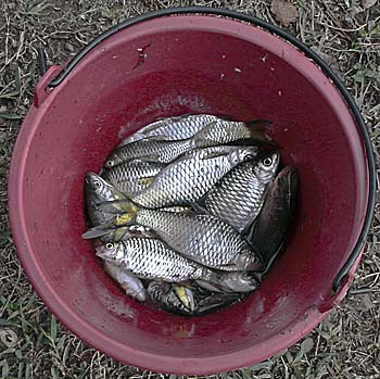
Easy Prey
One early morning an angler appeared next to my place. Every time he threw his rod into the water, immediately after he pulled a fish out. Within a short time the bucket filled up. Image by Asienreisender, 2013
At the beginning of dry season at the end of October / early November other fish species are migrating riverupwards from Cambodia. They come to the 4000 Islands or wander further riverupwards to spawn. Local fishermen catch a critical part of them for their own needs or to sell them to the markets of other places, including the biggest city around, what is Pakse.
Over the duration of the dry season other fish species arrive, either to spawn here or to make their way further upwards to spawn there. The locals catch many of them in simply-done, but big bamboo traps. The fish who migrate along are middle-sized or big fish species.
The Hoo Sahong Channel is a critical passway for certain migratory fish species. Due to heavy overfishing in the channel the species are suffering and getting endangered. This is not a new problem but happened already decades ago. It's just too easy for the local fishermen to catch fish in this bottleneck. Fishermen living upstream up to Vientiane claim that they wouldn't catch enough fish anymore to feed their families because many fish species suffered too heavy losses at the 4000 Islands. Because of that the Laotian government repeatedly banned fishing in the Hoo Sahong Channel. With little effect, it seems.
A Dolphin
A single Irrawaddy Dolphin south of Don Khone, already in Cambodian waters. Some 100m away from the photographer. Normally they appear in couples. Besides they come only for a very short moment up to the surface and it's barely possible to predict where they will come up next time. Just to mention that: the Irrawaddy Dolphin is not a fish, it's a mammal. Here we see one of the lousiest images of Asienreisender, 2013
At the end of 2013 news spread out that exactly at this channel a new dam is under construction. The dam building started secretly and is meaned for producing hydroelectricity. Blocking this channel has a severe impact on all the fisheries upstream and hurts the migratory fish species heavily. It's highly supposed it will lead to the extinction of many species, including the Irrawaddy Dolphin. This dam is another coffin nail for the wildlife of the Mekong River.
Mekong fish is the most important source of animal proteins for a great part of the people of Laos, Cambodia and Vietnam (up to 90%).
In July, when the Mekong River has increased to a high water level, many traps and fishing nets are swept away by the strong current. The local people, as careless and minimalistic operating as with anything, don't remove them right in time. The loose fishing nets then become a deadly trap for other fish and also the Irrawaddy Dolphins, of who many find a miserable end in them. This dull and disgusting behaviour of the local fishermen is as weirder if one considers that it is a self-harming behaviour to waste and destroy the own natural resources they live from and depend on, directly in front of their door.
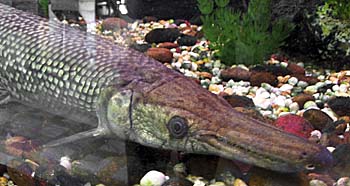
A Mekong fish, seen in an aquarium in Nakhon Phanom, Thailand. One of many other fish who appear in the middle section of the river. It's a fish of prey, obviously. Image by Asienreisender, 2010
Well, as just mentioned there are a few couples of the Irrawaddy Dolphin left in the river section south of Don Khone. Most of them appear at the Cambodian side of the river. A WWF (World Wildlife Fund) estimation from 2011 numbers the Irrawaddy Dolphins in the whole Mekong on between 78 to 91 individuals. A few decades before there were thousands of them living in the great river. It's rather probable that the Irrawaddy Dolphin will extinct within the next few years. Particularly as a result of the new Don Sahong Dam, which will cut off the food sources of the dolphins.
The Irrawaddy Dolphin enjoys a certain publicity and respect even among the local population. There are numerous stories around that dolphins helped fishermen driving fish into their nets and even rescuing peoples lives from drowning, when fallen into the water or being attacked by crocodiles.
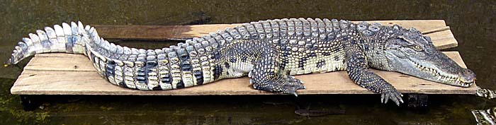
Crocodiles do not appear here anymore. They must be extinct around here and are nowadays mostly bred in stations under industrial conditions in Thailand and Vietnam. A crocodile skin brings a lot of money, but as an animal in the wild it is a permanent danger for people living with and in a river.
A Croc in Captivity
Acrocodile in a fish farm in Isan near Nakhon Phanom. In former times the Southeast Asian rivers were rich in saltwater crocodiles and Siamese crocodiles. Now they are mostly extinct in wildlife, but widely bred in crocodile farms for their valuable leather. Crocodile meat is also edible. Image by Asienreisender, 2010
The Mekong between Si Phan Don and Phnom Penh
Short behind the 4000 Islands runs the borderline to Cambodia. A couple of years ago it wasn't safe to cross the border here. Banditry happened, and the border wasn't open frequently. Meanwhile the bandits are integrated and sit in the custom houses and charge the border-crossers extra money for getting the mandatory repression stamp into the passport.
Stung Treng's river promenade at the San River, another large river who is coming from Ratanakiri and joins the Mekong. Image by Asienreisender, 2013
This part of Cambodia is deepest province. Left to the Mekong, Ratanakiri Province stretches out until the Vietnamese border in the Annamite Mountains. Not long ago covered with dense tropical rainforest, the landscapes now are dominated by plantation monocultures. Powerful Vietnamese companies can play their game here as it pleases them.
Stung Treng is the first bigger town at the river banks in Cambodia. It's a sorrowful, dirty place. At Stung Treng three other bigger rivers join first together and then the Mekong; the largest is the Tonle San.
Another big bridge is here under construction, operated by a Chinese company. The construction of another megadam started as well at Stung Treng, as news published in early 2014.
The Mekong Bridge at Stung Treng
Another Mekong Bridge, here at Stung Treng; still under construction in end of April 2013. The river promenade of Stung Treng is placed at the also very wide San River. A big bridge over the San River is already in place. Though, the bridges promote individual traffic, what contributes considerably to environmental pollution. But the really destructive impact for the rivers ecology are the dams. At early 2014 there were news reports about another megadam construction at Stung Treng. Image by Asienreisender, 4/2013
15km before the next bigger port town, what is Kratie, the river provides a second last habitat for a very few of the last river dolphins at Kampi. For this reason an unavoidable tourist industry established their business here. Fishermen who offer boattrips to watch the dolphins. The best time to do so is at dusk or dawn. The boat operators tell you nevertheless that any time is fine to go. 'Business now!' is their slogan.
A Green River
The Mekong River between Kratie and Kampi. It's wide here and thousands of sandbanks appear over the months of the dry season. Plants use the time to grow on the sandbanks, until they are drown in the rising water level from June onwards.
Image by Asienreisender, May 2013
Although some of the people here live from the business with the dolphins, some fishermen still hunt dolphins, if they can. A few decades ago, when there still lived thousands of the dolphins in the river, the Khmer Rouge found it a thrilling thing to kill them with machine guns - just for fun.
There is practically no doubt that the dolphins will be soon extinct.
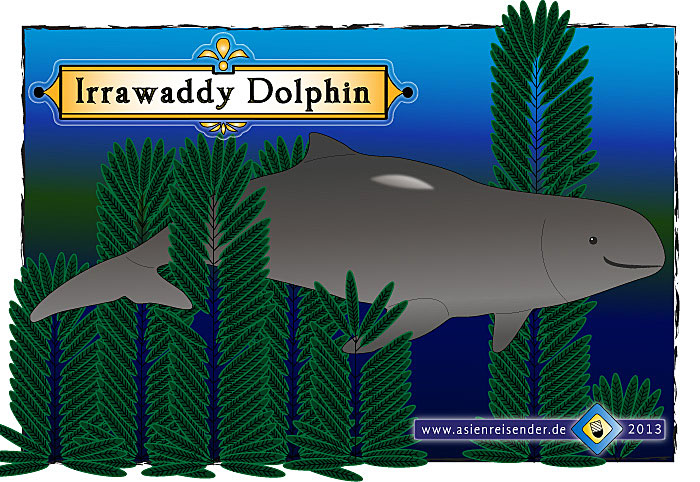
The Irrawaddy Dolphin
In lack of a decent photo here a sketch of one of the lovely animals. In distinction to the better known saltwater dolphins the Irrawaddy Dolphins do not have a beak.
Another new bridge over the Mekong exists in Kampong Cham, one of the bigger towns in Cambodia. Kampong Cham is a town in a better state than Stung Treng and Kratie are. A few kilometers ouside town there is another Angkorean site to visit: Wat Nokor Bachey, one of the smaller Khmer temples, but with historical significance and a history which dates further back into pre-Angkorean times. It could have been an important site for the civilization of Funan already.
The Mekong Bridge at Kampong Cham
Kizuna Mekong Bridge at Kampong Cham, built in 2001 by Japanese investors. Image by Asienreisender, 2013
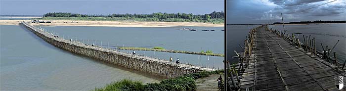
A Very Different Mekong Bridge
A large bamboo bridge over a sidearm of the Mekong River to an island, closely by Kampong Cham. It's the biggest bamboo bridge I personally have ever seen. Motorbikes pass over frequently, even cars and lorries use the bridge. Every monsoon it's getting drown by the rising stream, and every time after it's getting rebuilt. Images and composition by Asienreisender, 2013
The Mekong Delta
The delta of the grand river is huge and starts already at Phnom Penh, Cambodia's capital. Phnom Penh is also the biggest city the river passes by. Saigon / Ho Chi Minh City is not directly situated at one of the delta arms.
Phom Penh as the booming industrial center of Cambodia contributes a great deal of pollution for the lower section of the river system. A belt of garment industries is placed south of the city; their ambition is to produce as cheap as possible for the world market. Cheap always includes to spare environmental standards. Not to mention the exploitation of human labour.
The Mekong River Crossing at Phnom Penh
The confluence of the Tonle Sap and the Mekong River at Phnom Penh. Here another huge building site was under construction in May 2013; new house blocks for the wealthy. Image by Asienreisender, 2013
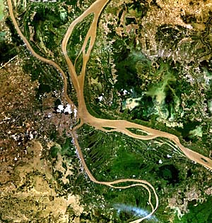
A satellite image of the river system at Phnom Penh. The city is situated at the west bank of the Tonle Sap River.
The Mekong River system at Phnom Penh is something unique in the world. The river system here forms a kind of cross. First the Tonle Sap River from inner Cambodia is joining the Mekong River. Then the Mekong shortly afterwards splits up again into two big arms; one of them is called the Bassac River, the other one is still called the Mekong, although both are Mekong streams. But really peculiar is here that the Tonle Sap, who is over months in the dry season feeding the Mekong, in monsoon turns into a sidearm of the Mekong, receiving water from the main stream. The inclination here is so little, that the rising water levels in the monsoon is pressing the water into the other direction. The water level can rise here in the rainy season for 15m, as mentioned already above. That makes the Tonle Sap then running in a reversed direction, feeding the Tonle Sap Lake instead of draining it. The Tonle Sap Lake is the biggest lake in Southeast Asia and part of the Mekong River system. It is due to the sophisticated river behaviour that the medieval city of Angkor Thom could be constructed as a hydraulic city with a superiour food production. The dam constructions riverupwards will have a deep impact on this ecosystem as well.
Following now the main arm of the Mekong down from Phnom Penh, it's flowing through a great, green plain, and splits up into more and more sidearms. Because of the nine main Mekong arms in the river's mouth the Vietnamese also call the Mekong here the 'Nine Headed Dragon'. The Mekong Delta is among the five biggest river deltas in the world. 20 million people live alone in the delta region.
The Mekong Delta around Phnom Da
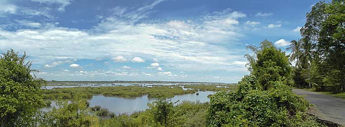
Flooded plains in the Mekong Delta around Angkor Borei. What is now all under water fell mostly dry in the following months. In April there is large rice cultivation around this scenery. Only some canals are still filled with water and serve as waterways for boats. These canals are partially thousands of years old. The Mekong delta around Angkor Borei is a very old cultural landscape. Image by Asienreisender, 11/2013
Here the same scenery in the dry season. Rice paddies so far the eye can reach. The photos are taken from Phnom Da; on this small mountain the trees lost their leaves due to the draught. Below, around the temple building, the trees are still green for the ground water level is high; the surrounding rice paddies need the water (wet-rice cultivation).
The Mekong Delta here is merely 2m above sea level. The higher elevations, apart from mountains like Phnom Da, reach up to 10m. Under ongoing global warming and a rising sea level greater parts of the delta might get overflooded in the future. Salt intrusion is already a serious and the agriculture damaging problem in the lower parts of the delta in Vietnam. Image by Asienreisender, 4/2014
Every year tons of silt come down with the river. The whole lower landscapes, who feed millions of people with fish and rice, are the result of tenthousands of years of silt sedimentation. Part of it might have coming down all the way from the Tibetan Plateau. The delta plain of the Mekong River is still expanding into the South China Sea. However, silt transport with the river will come to an end, because the new dams will block the natural flow of water and silt. On the contrary, the silt is a major problem for the efficiency of the dams itself. The dams also harm the whole agriculture particularly in the delta region.
Fertile River Plains
The plains of the Mekong delta in the dry season around Angkor Borei. In the foreground one of the canals is to see, used frequently by boats. Image by Asienreisender, 4/2014
The part of the Mekong delta in Vietnam accounts for 50% of the country's total rice production of 28 million tons. 90% of Vietnam's rice exports grow here. According to Milton Osborne at the many mouths of the river are flowing 495 billion m3 water annually into the South China Sea. However, the water volume declined in the last 30 years already by 10%. The water withdrawal in China alone costs it's tribute. This article is focussing on the main stream of the Mekong, but there are several dams on a number of tributaries as well who pay their tribute to ecological change.
The Mekong Delta was, certainly because of it's rich natural resources, home for the first civilization in Southeast Asia: Funan. Shortly before the Mekong is entering the territory of Vietnam, there are a number of ancient sites. One of them is Angkor Borei, which has been a city in the empire of Funan and was later a place in the empire of Angkor. Nearby Angkor Borei there is another ancient site with roots to the very beginning of civilization: it's the pre-Angkorian temple tower on the peak of Phnom Da and a second, very nicely designed old Hindu temple with clearly Javanese origin.
The Mekong Delta in Vietnam
The delta gets much wider in the river's very last section. While the river and canal net in Cambodia is still relatively little populated and relatively quiet, in Vietnam millions of people live along all the many sidearms. The industries are here much more developed and the whole infrastructure is much more busy.
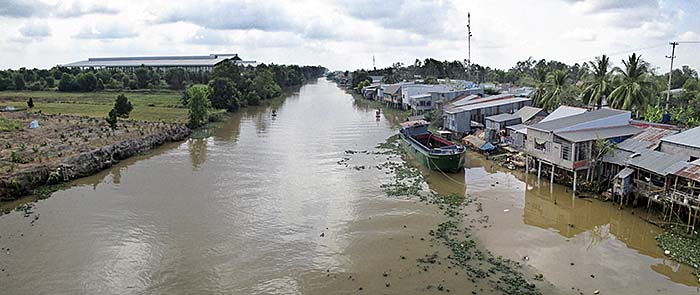
Canal in the Mekong Delta
O ne of the many canals in the lower delta in Vietnam. The canals are often crammed with cargo ships. These landscapes have been transformed by humans since two millennia at least. In the Funanese times such canals connected a number of places. Between Angkor Borei and Oc Eo ran a canal over a length of about 80km. Now, under deployment of the technology of the 21st century, the transition is going on faster than ever. Image by Asienreisender, 3/2016
Environment
The Mekong is the second richest river in biodiversity on earth, after the Amazon river in south America. In the 'Greater Mekong Subregion' are living estimated 20,000 plant species, 430 mammals, 1,200 birds, 800 reptiles and amphibians and an estimated 850 to 1,200 fish species. In 2009, 145 new species were described from the Mekong Region, comprising 29 fish species previously unknown to science, two new bird species, ten reptiles, five mammals, 96 plants and six new amphibians.
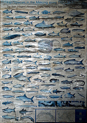
Mekong Fish Species
Fish Species in the Mekong along the Thai-Laotion border. It's just a small choice of the Mekong's wildlife. Image by Asienreisender, Chiang Khong, 2011
The Mekong is home to more large fish than any other river on earth. Among them are the Giant Catfish and the Irrawaddi Dolphin, a sweetwater dolphin species (factually a mammal and insofar not a fish). The Mekong Freshwater Stingray gets a wingspan up to 4,30m, that's half the length of a bus. The Siamese Giant Carp and (formerly) the Siamese Crocodile are living in the Mekong as well. One finds otters here and bigger fishing cats. A quarter of the earth's giant fish is living in the Mekong River. To be scientifically counted as a giant fish a species must grow up to at least two meters or gain a weight of minimal 100 kilos. Until today the greatest ever recorded catch of a freshwater fish was done in 2005 in north Thailand with a 270cm long and 293kg heavy Giant Catfish.
Especially the big species are under pressure and struggle to survive. The Saltwater Crocodile, which once lived in the lower Mekong up until the Tonle Sap Lake, is already extinct in the river.
It is estimated that annually 2.6 million tons of fish are caught from the Mekong in the Lower Mekong Basin (LMB, Milton Osborne). Another 500,000 tons are bred in aquaculture. With improved fishing technologies and an increased population the harvest of fish seems already not sustainable. But the populations around the Mekong River are growing. Cambodia and Laos with their grand baby booms are expected to double their populations within the next twenty years. That would be 30 million Cambodians and 13 million Laotians in around 2034. The population growth in Thailand and Vietnam is estimated by roughly around 25% until 2034, still a large increase for a 70 million and a 90 million population. All these people need to be fed, and the Mekong is the main source for proteins and agriculture in the region. Even without the impact of the Mekong dams there would be an increasing problem.
Fish catches per fisherman have clearly declined in the last few decades. In the past a Cambodian fisherman caught almost the double amount of fish than nowadays. Besides, the size of the fish is smaller now - they more and more get fished before becoming grown-up and mature.
Environmental Impacts
There are already seven dams built at the upper Mekong (Lancang) in China. The dams have a big impact on the nature. Numerous species extincted already due to the dam costructions, particularly because many fish species are migratory. When the routes to their spawning spots are blocked, they can not reproduce anymore. More dams in China are under construction and in planning.
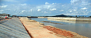
Chiang Saen Port
The new river port of Chiang Saen. When I made this picture it was still under construction. Meanwhile it's finished and connected with a big road to Chiang Saen and from there further south to Chiang Rai, Chiang Mai, central Thailand and Bangkok. Image by Asienreisender, 2011
Besides there were more changes done on the upper river. Rocks were blasted, what hits animals as well, because it destroys their hideouts and hatcheries. Besides the fishing industries overfish the river.
Although looking green and nice, there is also in the middle part of the river great damage done already to the environment. Overfishing and slash and burn of the forested hills and mountains around hurt the nature.
But now there are running projects to Dam the Mekong in Laos and Cambodia. In Sanyabury/Laos a first big dam is already under construction, followed by the above mentioned Don Sahong Dam. Meanwhile there started another building site for a megadam at Stung Treng in Cambodia. These projects will trigger a mass-extinction of species and finally destroy the river's natural ecology. Many more dams will follow.
Global warming has also a direct impact on the Mekong River. Since the Mekong's sources are located on the Tibetan Plateau and the first waters are coming from the glaciers, global warming makes the glaciers melting away. They loose substance. The glacier's mountain landscapes change. The glaciers will probably completely disappear in the next 20 to 30 years. That means for now and the coming years more glacial water flowing into the Mekong. For the future, without glaciers, the situation is not clear. More rain in a warmed atmosphere might lead to a compensation for the loss of fresh glacier water.
The Mekong Delta therefore is already suffering much salt intrusion. It's probably that it comes due to sea-level rising, triggered by global warming, in combination with a reduced water spill of the Mekong itself. The dams on the upper Mekong, who withdraw considerable amounts of water for irrigation purposes, might have caused that. However, more salt intrusion in the Mekong Delta is to expect for the coming years. In 2014, the news at the end of dry season indicated an unusually high amount of salt intrusion in the lower delta region in Vietnam. That repeated more severe in 2015/2016; a large drought in Indochina (due to the notorious El Nino effect) led to a very low Mekong water level, salt intrusion into the delta in Vietnam hurts the farmers heavily. In April 2016, China opened dams in Yunnan to compensate the lower tributary states. Since there is the center for the Vietnamese rice production and the production of other sweetwater based agricultural products located, Vietnam is listed as one of the five countries in the world who will mostly suffer a rising sea level.
To summarize my concerns, I have to claim that here, in the greater Mekong subregion, a considerable part of the world's ecology is going to die. That means a huge step forwards for mankind towards the 'point of no return', from when on it's too late to recover the biosphere from the global world destruction.
Capitalism is blind dynamics. It's following an internal code, or an inner law. All the development is not for the sake of the people, but for profit only. Making two dollars out of one, and ever repeating the stereotype pattern. Eternal growth. Doesn't matter the consequences.
Besides, the quality of everything what is built here, particularly in the construction sector, is miserable. Many installations are already broken before completed. So, the next step is to either fix the broken parts or let it rot. In reality both happens. But, in fact, it's all rotten crap what the industries built here, not meaned to last long. Repairing is following business. And means more environmental impact. And so it goes on, without end - until nature sets an end.
In fact in many cases not even the plugs fit into the sockets. One has either to bang them in with a hammer or, in the other extreme, they don't stick and fall out by themselves.
The example of the dams on the Mun River shows that the dams fill up with silt sedimentation. They are not as profitable as it is first promised. But, above all, the produced energy is mostly wasted by the industries who produce consumer crap what is short-living and dysfunctional. On the consumer side the people also waste much energy for nonsense or self-harming purposes (e.g. producing noise pollution). Production for profit means producing waste for the consumer circle. It mostly doesnt meet real human needs.
Well, so it looks. There will be an end. This global socioeconomic system will certainly not come over the middle of the 21st century. When all the basics of our needs, the natural resources are wasted, destroyed and polluted, mankind won't survive. The destruction of the natural surroundings of the Mekong River's ecology is just one significant regional example for this thesis. It's following a pattern which is going on everywhere on earth, in an accellerating speed.
Swimming the Mekong
Knowing the Mekong River since years, having observed it at many different places, made me sometimes wondering how it would be to cross it by swimming. Well, that's definitely an easier thing to do at the Golden Triangle, in Chiang Saen or still in Luang Prabang, but no more that easy in Vientiane, Nong Khai or further downstream. As more tributaries the Mekong join, as bigger he grows. Besides there is much more water in the Mekong in rainy season than in the dry season. Some of the river's islands only exist in dry season and disappear when the river rises up for some meters.
Anyway, after a years-long incubation time I finally went into the water in February 2013 at Chiang Khong. There is a small, sandy peninsular close to Namkhong Restaurant, where in the afternoons kids from Laos and Thailand meet and play football. From there I started and swum over to the big sandy island almost at the other side of the river. It's already Laotian territory there.
As expected the strong drift pulled me a good piece downstream, but not too far. The drift is easily to recognise when just observing the surface of the river. To compensate the drift and to come back to the same point where I started from, I had to walk the island upwards. In fact there are two islands here. Between them is a gap of only a few meters. From the riverbanks it looks easy to overcome it, and somebody told me before, it would be just an easy walk through the shallow water. But it wasn't. The drift between the two islands, although a few meters wide only, became the biggest obstacle. It's deep and so strong, that it pulls a swimmer rapidly downstream and it was a great challenge to avoid losing control and being flushed downstream into Laos. Nevertheless, after reaching the upper island I walked two hundred meters further and made the swim back from there.
So, at this afternoon I was in Laos by my own means, without border control, passport and visa. For the local people a common thing, but they go by boat. Swimming is only the choice of either refugees, who try to escape one country to reach another, or weired sportsmen.
Well, there are some concerning thoughts about that. The local people would first fear the big fish (Giant Catfish and others), big river nagas (river snakes) and a lot of spirits who allegedly live in the water (monsters, some might be good, others are nasty ghouls and so on).
Asienreisender, crossing the Mekong River. Image by an observer of the action, 2013
Well, the havoced animal world was of little concern for me, at least in terms of being harmful, for I know that all the big animals are caught out of the river, particularly here at Chiang Khong and Houayxay. Too many fishermen are around here every day to give big fish a chance to survive. Daemons, deities, zombies and other monsters and spirits have fortunately no power over me.
The realistic concerns are the drift, which is very strong and can pull one too far downstream, the water quality (much waste water from all the settlements at the riverbanks and the Chinese industries at the upper Mekong), maybe swirls who can pull one under water, and bigger peaces of rubbish like trunks etc. who drift downstream and lead maybe to a hit. Well, and not to forget the riverboats, in case they come too close and the boatsman is too drunken to see what's going on around... The boats are very noisy, so screaming would be overheared...
A very short History of the Mekong River
Some fourthousand years ago people already settled at the riverbanks of the majestic stream. The first Southeast Asian civilization of Funan thrived some 2,000 years ago in the delta of the Mekong. The famous Khmer civilization of Angkor wouldn't have existed without the Mekong - Tonle Sap ecosystem, providing fertile soil for a rich agriculture and great surplusses of food, means fish, rice, vegetables and much more. The great times of Angkor were between 802 AD and 1431 AD.
After Siamese troops sacked Angkor Thom in 1431 CE, the river formed kind of a border between expanding Siamese influence and it's Vietnamese counterparts in the east.
In the 16th century first Europeans came to the region. Very first were the Portuguese, followed soon by Spaniards, Dutch, English and French. The French colonialized growing parts of Vietnam from the early 1860s on, encountering the Siamese and pushing them back step by step. The French empire signed a treaty with the Siamese empire in 1893, making the Mekong over wide streches the border between their territories. A certain part of territory west of the river, including Luang Prabang, became included to so called 'French Indochina' in 1904, as well parts of Cambodia in 1904 and 1907. This old colonial border as it were forced by France in the times between 1893 and 1907 is still the existing border between nowadays Thailand and it's easter neighbours Laos and Cambodia.
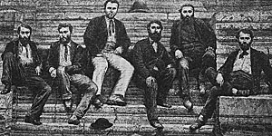
Members of the French Mekong Expedition at Angkor in 1866. Image: wikipedia.org
The French colonialists also explored the Mekong River. They were in hope to get a shipping route from the South China Sea to deep inside the main land and inner China. In 1866 the French Mekong Expedition explored the river upwards until into China. But, since there are the rapids at Sambor (a bit above Kratie) and other obstacles and, above all, the Mekong Falls at Si Phan Don, the route was never navigable over the whole distance.
In the late 1950s there were first plans do dam the Mekong River. One dam was proposed to be built near Vientiane, another at Savannaketh, a third in south Laos and one in Cambodia at the Sambor falls. There was practically little or no consideration of the ecological impacts of such dams in that time. A replacement for 250,000 people would have been required for the dam at Savannaketh alone. But it came different.
After the Second World War there was much fighting in Laos, Cambodia and Vietnam. First, France sent troops and claimed 'it's' colonies back. That led directly into the first Indochina War, because the local populations weren't willing anymore to accept foreign rule. The French colonial army finally lost and three independend states were born, but, the dark times were continuing.
The American aggression in Vietnam from 1964 on quickly streched over to Laos and Cambodia. All three countries were heavily bombed and destroyed. All the plans for developing the countries and building dams were forgotten. After the Americans lost the Vietnam War (also called the 'Second Indochina War'), they left an incredible chaos especially in Cambodia, which was overtaken by the Khmer Rouge then. These three countries then were under communist rule. Until 1990 there was a strict cold-war border between Thailand and it's eastern neighbours. The situation relaxed since the early 1990s. Since then the whole Mekong region started to develop economically. All the formerly 'communist' states alligned their economies to the neoliberal world order. The economic boom now demands it's tribute from the natural environment. The Mekong River is going to be butchered for the sake of development.