In Thailand the provinces have the same names as the province capitals. So, Ranong is as well a province capital as a province. Ranong town is a quite remote place at the northern Thai Andaman Coast, Indian Ocean. Founded in the time around 1850 by Chinese migrants, it's a rather young settlement. In the past it gained importance due to it's tin mines around, where most of the Chinese population worked as miners. There were also uprises against the exploitation and the Thai domination in the reign of Siam's king Chulalongkorn (Rama V, reigning from 1868 - 1910).
An Old King's Palace
Rattanarangsan Palace, now situated in a small park at Kamlangsab Road, is a 19th century palace of Siam's king Chulalongkorn (Rama V) and was originally situated at another spot in Ranong. Now there is a small museum inside, but unfortunately it's always closed. One needs to arrange an appointment for visiting it. Fortunately I went one day along when the frequent cleaning was done, and the staff allowed me to go inside. There are old furnitures like the king's bed, a princess' bed, two old desks, a very comfortable looking couch etc. Besides there are a number of old photographs, some paintings and the atmosphere of a place wich is abandoned since a long, long time. Remarkably, under the ceiling were two bats hanging. Their excrements falling down on the floor, the staff just put a piece of newspaper on the ground and left the animals up there untouched. Very much to my approval. Image by Asienreisender, 2012
The reason for Ranong's remoteness is the fact that the main north-south road axis, which connects Bangkok with Penang, Kuala Lumpur and Singapore, is following the eastern coastline. The main road wich leads through Ranong and follows the western coastline of this part of the Malay Peninsula up to Phuket is a much smaller, much less used road with only a few and small places here and there at it's sides.
Ranong is not a typical place for Thailand. A considerable part of the population is still Chinese, as in not few other Thai towns and cities as well - they are normally the most ambitious business people. Another significant part of the population is Burmese or of Burmese roots. The local Burmese are mostly these pretty puppet-like, small, slim people. They dominate the fresh markets and small foodstalls around the main market. Many local Thai People look pretty much the same like the Burmese. Thai People are ethnically a very mixed-up population, and the local Thais are different from the ethnic 'average' in Thailand. Very few western expats are to see here.
There is also a strong minority muslim population in Ranong town and around. There are mosques as well, unavoidable of course. There is also a mosque in the close neighbourhood where I stay in Ranong town. Remarkable, they don't shout out their noisy 'Allahu akbar and whatever'. Pretty sure, they aren't allowed to.
Ranong Town
Ranong town itself is certainly of no further attraction. It's sulky, faceless and boring, without any peculiarities. Image by Asienreisender, 2012
As same pleasant is the absence of all the national anthem being played and the political propaganda announced by public loudspeakers. I never heared that in Ranong, although it's notorious almost everywhere in Thailand, except of a few, very remote and small places in the mountains. That makes Ranong defenitely a more pleasant place than all the other, noisy places in Thailand.
Ranong town is a small place with plenty of rain. There are about eight months southwest monsoon (the rainy season) and only four months dry season in Ranong.
There is practically nothing of significance here. The town is rather shabby looking and a bit back in time even for Thai measurements. The sidewalks are messy in a way the Thai authorities abolished meanwhile in most of the other towns and cities in Thailand. Too much crap is crammed on the sidewalks and while and after a raining shower it's dropping from the roofs everywhere on the sidewalks so that one better does not walk there anymore without an umbrella. There are very few rain gutters installed at the roofs - that's no standard in Southeast Asia. Even six or eight hours after a strong rain it's dropping here and there.
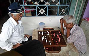
A Chess Variation
A 'Thai Chess Game', as the players explained me. No king, different rules... a rough adaptation to chess. I have seldom seen that in Thailand. There is a similar chess variation in Cambodia; but they play again with certain different rules and figures. That might be very particular, old and local variations of the chess we know today as international standard chess. Image by Asienreisender, 2012
The shabbiest part of the town is clearly the district around the piers. A lot of Burmese workers live there and the whole surrounding is coined by slums and dockyards. It's dirty and smelly, and the men around there do not look very trustworthy.
Since Ranong is a kind of a border town, although there is only one Burmese place on the other side of the border, it's as any other border town different than the places inland. It's supposed that there is a higher rate of criminality here, not only the usually smuggling, but also theft of vehicles, because they can quickly be moved out of the country and sold in Burma.
Despite the tediousness of the town there are three reasons to go here. First, it's a port for two attractive islands, Ko Phayam and Ko Chang. Second, it's a base for a visa trip to Kawthaung. Third, it's surroundings are great. There is the seashore with huge mangrove forests and there are wild mountains a few kilometers east of the shore covered by tropical rainforest. It's defenitely worth to rent a motorbike and explore Ranong Province.
Map of Ranong and it's Surroundings
Overview map of the northern Andaman Coast around Ranong. Image by Asienreisender, 2012
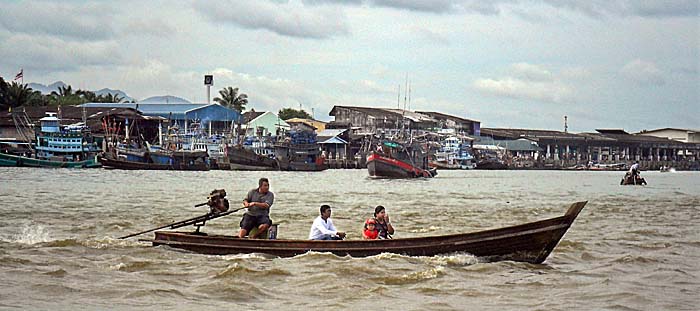
Ranong Pier
Ranong pier is the port for all the many fishing boats who go out here every evening and for all the transport vessels who leave for or come from Kawthaung/Burma. Image by Asienreisender, 2012
2.
Vegetarian Festival
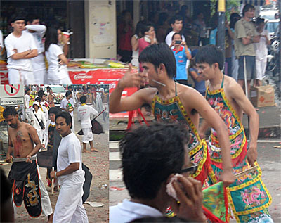
The Vegetarian Procession
Bumm, bumm, bumm. The 'vegetarian festival' is another grand reason to be noisy and perform public nonsense, like the waterfestival 'songkran', just to give one more example, is as well. Images by Asienreisender, 2012
There is a strange custom here along the Andaman Coast among the Thai People with Chinese roots. It bears the harmless name 'vegetarian festival' ('bang neow'). But it does not only mean that meat is avoided, alcohol banned for sale in the shops (even fast-food and crap-provider number one, the seven-eleven supermarkets don't sell alcohol for a day) and sins are expiated, it is also a kind of carnival where many of Thai-Chinese, dressed in white clothes, process along the town streets and hurt themselves by using knifes, metal thorns, swords etc. to puncture their tongues and cheeks. Looks pretty nasty. Some blood is flowing. Not much, though. A lot of fireworks is banging, and the participants of the spectacle walk with their bare feet on the firework as it were pillows. I have heared some walk over burning coals as well. The annual festival goes on for more than a week.
I knew a similar custom only from India yet and was surprised to see it here in Thailand as a Chinese custom. By the way: how do they do that? Yet I have no clear answer to that question.
3.
Moving around Ranong
Offroad
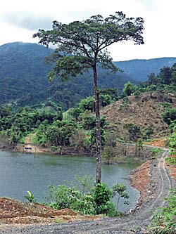
On the trial to circumnavigate Hat Som Paen Lake, one follows a slippery and partially pretty steep dirt track into the mountains picturesque landscapes. Image by Asienreisender, 2012
Driving allways, not only in Southeast Asia, means one has better to be very carefull, above all driving slowly and always being prepared to break. Thai People generally drive very slowly themselves, what makes the streets safer. Though, they don't always follow the rules and there is always much to see at the right and the left of the road, so it's easy to get distracted. And there are masses of dogs on the roads, most of them straying dogs. They appear normally in packs, three, six, eight, twelve dogs. Laying on the streets where is little traffic. Sometimes some get aggressive, and that's a considerable danger when driving. I frequently wish them to hell. Many locals feed them regularly, mostly elder women. They don't care for the dogs at all; many of the beasts are sick with scabies, rabies and whatever - but they feed them. That makes the population growing more and more...
Since they are such a plague, at a certain point, complaints grow overwhelming. Then usually the authorities react on that with a poisoning programme. Many pets die by that as well, but the straying dog population is reduced significantly. At least for a time. Some dogs always survive, and after the end of the programme the number of remaining straying dogs grows again...
Anyway, there is much to discover around Ranong and since there is generally little traffic outside the town, it's easy going to drive here.
The Landscapes north of Ranong
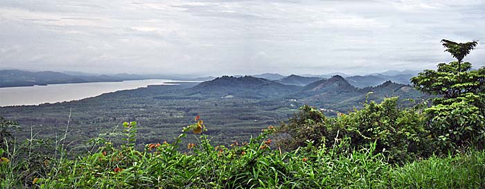
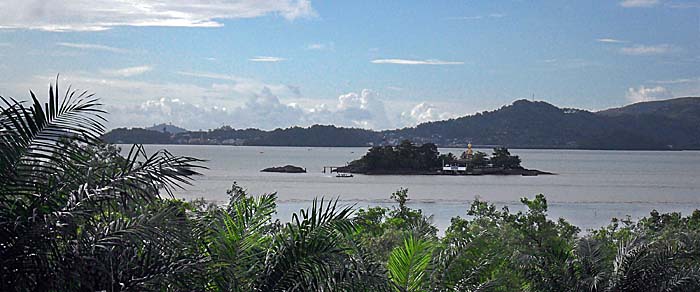
North of Ranong, towards Kraburi. The waterway at the left is part of a long, spiky sea bay, marking the border between Thailand and Burma. At it's northermost point the Kraburi River enters the sea. This point marks the 'Isthmus of Kra'. Image by Asienreisender, 2012
Ranong's Coast
View over the coastline of the Andaman Sea to Kawthaung (back left). On the island in the foreground is a Thai border post placed. One has to run through three checkpoints on the Thai side and another two on the Burmese side to enter Kawthaung. With the 'visa at arrival' one is merely allowed to move within a 5km sector. Image by Asienreisender, 2012
4.
Hot Springs
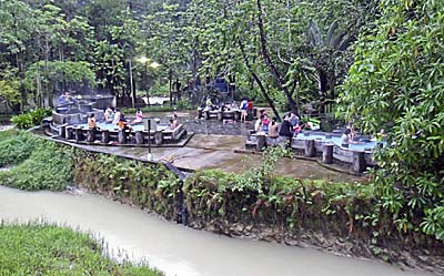
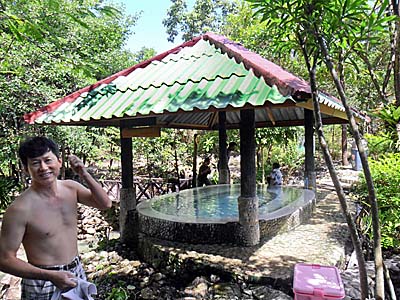
Many people who visit Ranong praise the hot springs, a kilometer east of the Petchakasem Road (what is the main north-south road, leading to Phuket in the south and to Chumpon in the northeast). Sulphureous water comes out of the mountains and is queued in some pools. The place is famous since king Chulalongkorn in the late 1890s visited the spot. Now there are some pools which are free for the public and, additionally there is another, special pool where entrance is charged (40 Baht).
Ranong's Hot Springs
The free-of-charge part of the Ranong Hot Springs at the lower part of the place. Image by Asienreisender, 2012
There is also a recreation area directly nearby. It's a bigger space, covered with a big roof. One can go here and have a rest on the ground. Some people bring a mat with them. The ground is heated by a system of pipelines who contain hot spring water. There is no entrance fee for that and many people go there, particularly on holidays and weekends. Though, it's too warm for my taste. Even in monsoon time the surrounding temperature is 25 degree celsius or more. No reason to heat one up, I would say.
The nearby temple is dedicated to the well spirits. Southeast Asia is full of ghosts, deities and daemons.
There are some more spots with hot springs around Ranong town as in Ngao National Park (see below).
5.
Ranong Canyon
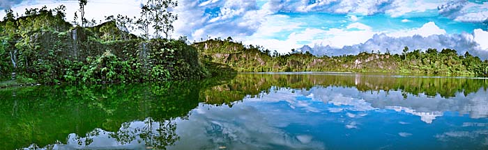
Well, since I personnaly really don't long for hot water in the tropes, I prefare another, much more charming place. That's nine kilometers upwards the road from where the hot springs are. It's Ranong Canyon. The canyon is surrounded by steep, but not high slopes, and has a big pond on it's ground. It looks to me as it was a former quarry.
It's normally quiet here; two small wooden restaurants are at the side of the small bypassing road. The pond is full of fish. Local visitors buy fish food at the restaurants and feed the fish so that they grow big and fat. Then the restaurant owners, who benefit from the feeding twice, catch and sell the fish in their restaurants or eat it themselves.
Ranong Canyon is a great place to relax and to hang out for an afternoon in a hammock. It's also possible to swim here and to jump into the water from some of the cliffs.
The Lake of Ranong Canyon
Ranong Canyon. Images by Asienreisender, 2012
6.
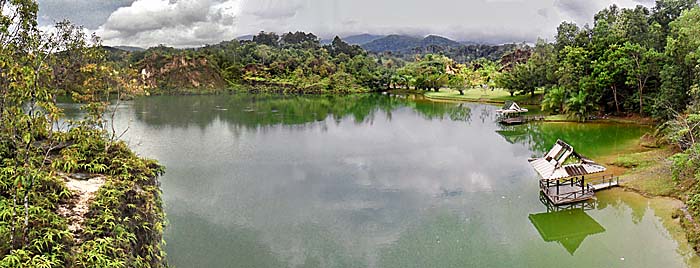
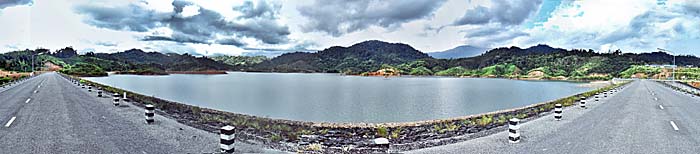
Hat Som Paen Dam and Reservoir
On the way between Ranong's Hot Springs and Ranong Canyon is a dam, queuing an artificial lake. Looks not too old and streches out quite far into the mountains. There is a dirt road at both sides of the lake. But they don't come together, it's not possible to circumnavigate the lake. The right road leads deep into the mountain scenery. A good starting point for a longer hike.
Hat Som Paen might be Ranong town's water reservoir.
Hat Som Paen Lake
The reservoir seen from the dam. The background is a really remote mountain scenery. Image by Asienreisender, 2012
There are also some National Parks around Ranong town.
7.
Laem Son National Marine Park
Some 50 kilometers south of Ranong, near Kapoe, is a Marine National Park; part of it's protected area comprises also the coastline. There are some small, uninhabited islands with big rocks at the shore. The coast is covered mostly with casuarinas, a Southeast Asian pine tree. Some of them are really big, the biggest of it's kind I have seen so far. Leaving the forest and approaching the beach it's all white sand. The officials charge 200 Baht entrance for foreigners (40 Baht for Thais). Inside is a resort, run by the government.
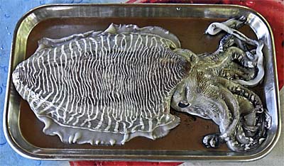
Octopussy
An octopussy in a restaurant close to the entrance of Laem Son National Park. Length about 40 centimeters. That's one of the many species who live here in the sea. Environmental protection is far not as strict as in western countries. Fishing always happens. Image by Asienreisender, 2012
It's defenitely not worth to pay the fee. At the entrance box one can turn left. The small road leads to a pier with a great view over the sea and a big bay with huge mountains behind. Before the pier is a small kind of conference building with a guard post and a cross bar. At this point there is a bridge leading over a stream into the casuarina forest. The way is paved and leads all through the forest into the National Park, bypassing the cash box.
Another possibility to approach the Park is turning right a hundred meter before reaching the cash box, following this small road and turning left where the 'Andaman Sky Resort' is signed out. It's situated directly at the beach in the National Park. No cash-box here, no entrance fee. One can walk along the long, sandy beach to the above mentioned resort inside the park. The 'Andaman Sky Resort' looks a bit neglected.
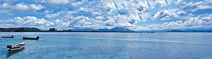
The Coast of the Andaman Sea
Huge bays and peninsulas appear along the coastline. Image by Asienreisender, 2012
8.
Ngao National Park
A few kilometers south of Ranong a small road turns left from the main north-south Petchakasem Road. It leads to Ngao Hot Springs, which is situated inside another National Park. As so often there is also a resort at the park entrance. These National Park resorts are always run by the state and are a bit overpriced.
Ngao Hot Springs
One of the Ngao hot springs. Thai People love to come here for relaxation. Image by Asienreisender, 2012
The park entrance is situated at the foot of the steep slopes of the Ranong mountain chain. The mountains partially extend a height of 1,000 meters. A number of springs and streams have their source there. Among them are six hot springs, usable for wellness purposes.
There are many birds and other animals living in this biotop, as well as many plant species. Among them is the rafflesia kerrii meijer, one of the very big parasits of the rafflesia family who have no roots and no leaves and represent the biggest flowers on earth. The rafflesia is named after Stamford Raffles, who is known as the founder of Singapore.
The entrance fee for Westerners is a hundred Baht (Thais pay twenty Baht). There are two bigger waterfalls high up in the slopes; they are visible already from further away, from the Petchakasem Road and behind.
A dirt road in a bad condition leads into the mountains, getting smaller and smaller and enters the jungle.
9.
Mangrove Forest
Some twenty kilometers south of Ranong is a mangrove research center located. It's placed on a hill and allows a good view over the coastal surroundings, who are covered by a huge, coherent mangrove forest. It's the biggest still remaining mangrove forest in Thailand and one of the most significant ones in whole Asia.
Mangrove forests are used as a source for gaining charcoal. A great deal of the local mangrove forest has been cut already but is partially growing new again after being reforested. Considerable parts of the forest also have been turned into shrimp farms.
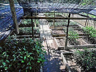
A Mangrove Nursery
The mangrove nursery of the research center. Image by Asienreisender, 2012
To replant mangroves is difficult and time-consuming. There is a mangrove 'nursery' at the research center, where collected seeds are raised up for some six months. After this time the small trees are big enough to be planted in sites which have to be cleared first from weed and bushes and dead plant material. After another six months the site has to be cleared of weeds again.
In the mangroves are some villages, whose people live there since generations with and from the environment what is now, since a few decades, by great parts a National Park. They use mangrove wood as construction material for their houses, and use it as firewood for cooking. Besides they catch fish, crabs, shrimps and other animals for their diet.
From the research center leads a longer walkway into the mangroves as an education trail. Some signboards give general information about the forest (all in Thai language). Many animals are to see on the ground and in the trees: mudskippers, crabs, fish of a variety of kinds, birds, insects of course (above all mosquitoes) and sometimes a group of macaques (crab eating macaques) appears. There is a huge variety of snakes home in the mangroves, cormorants, otters, monitor lizards and even slow lorises. They are very shy, rarely to see. Not to forget the omnipresent dogs, straying and hunting around. Mangrove forests appear a bit spooky - the mangroves are so adapted to the environment that they make a strict monoculture in their habitat what is elswere only the case under agricultural conditions.
Offshore is a huge marine biodiversity as well, including hundreds of fish species. This part of the coast is facing the two islands Ko Chang and Ko Phayam only a few kilometers apart in the sea.
The Mangrove Forests along Ranong's Coastlines
A huge strech of mangrove forest behind the covering seam of ordinary forest in the foreground. Image by Asienreisender, 2012
There are no crocodiles living here. No more. They are extinct since long in most of Indochina. It's supposed there are some saltwater crocodiles left in Burma. For industrial reasons the big lizards are bred in crocodile farms. As a source for leather for exclusive handbags for rich ladies who like to bedeck themselves with that.
I hope very much that the mangrove forests here will survive and do not come in conflict with the interests of big investors in the future. In this case the forests fate would be sealed.
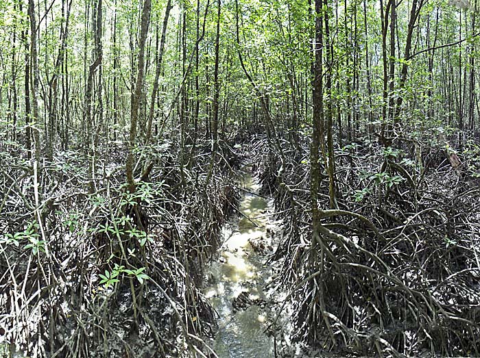
Inside a Mangrove Forest
Inside a mangrove forest. Typical are the high roots. All the trees are still thin and only a few years old. When growing old, mangrove trees can become big and reach a diameter of more than a meter. Image by Asienreisender, 2012
10.
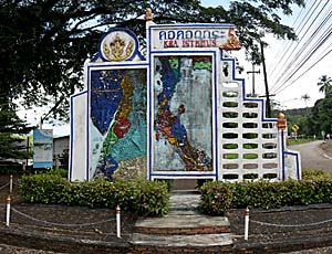
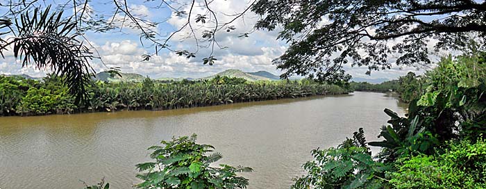
The Isthmus of Kra
In the north of Ranong Province the Malay Peninsula gets narrowest at the point where the river of Kra flows into a long, northern streching bay of the Andaman Sea. Nearby the small town of Kraburi is situated. The Kra River marks the border between Thailand and Burma/Myanmar. The Kra Isthmus is 44 kilometers wide between the Andaman Sea/Indian Ocean and the Gulf of Thailand/South China Sea.
Isthmus Memorial
The small memorial at the Isthmus of Kra. Image by Asienreisender, 2012
Since king Narai of Ayutthaya's times in the 17th century there are plans to build a canal (Kra Canal or Thai Canal), cutting the Malay Peninsula, comparable to the Panama Canal or the Suez Canal. It has never been realized. There are environmental concerns, for the area is mountainous (up to 75 meters) and digging a canal would mean to dig really deep. Besides there are political opponents for such a plan. Singapore, Malacca, Penang and other ports at the Strait of Malacca would loose their influence and turnover in the case all the traffic from China westwards and vice versa would use the shortcut at Kraburi. It's about 25% of the world's freights passing the Strait of Malacca. Loosing most of it would mean a sharp decline for Singapore's yet strong trade position. It's always rumored that strong lobbyist parties pay a lot of money to Thai decision makers to prevent the project.
At the Isthmus of Kra
The Kra Isthmus at the point where the Kra River is flowing into the Bay of Kra. Image by Asienreisender, 2012
In December 1941 Japanese troops landed at several points at the Thai coastline. One of these invasion points was closely south of Kraburi at the Isthmus of Kra.
11.
Ranong's Mountains - The Tenasserim Mountain Chain
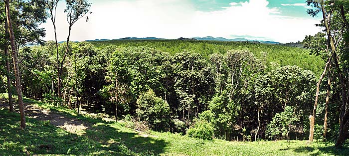
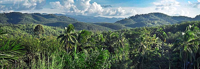
Ranong's mountains are part of a much bigger mountain chain, the Tenasserim Range. The Tenasserim Mountain Range stretches from the Three-Pagoda-Pass in Kanchanabury Province all the way down to Singapore and forms over 1,700km length the backbone of the Malay Peninsula. It's northern parts until Kraburi mark also the contemporary Thai-Burmese border. In the Tenasserim Mountains, consisting of granite and limestone, covered with jungle and sparsely settled, are still estimated 500 wild Asian elephants, 120 wild tigers and a number of wild water buffalos living. Many other species, some endemic only on the Malay Peninsula, live in these mountains. Even the existence of Sumatran Rhinoceroces has been reported in past decades; numerous appearences of the rhinos happend in 1962 and a last reported one in 1994 in Kota Tinggi (Malaysia), which has been captured. This mountain chain is older than the Himalayas; on the southern parts the rainforests are supposed to be the oldest forests on earth with an age extending 230 million years.
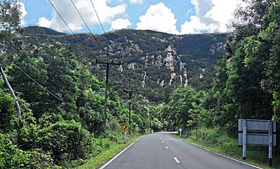
Steep Slopes
Approaching the steep slopes of the mountain range. There are only two passes with paved roads in Ranong Province and very few more opportunities to come over the mountains via dirt roads or tracks, who are mostly impassable in the rainy season. Image by Asienreisender, 2012
The big and long Tenasserim Mountain Chain also marks a natural border between Ranong Province and Chumpon Province at the eastern coast, at the Gulf of Thailand. The mountains mean moreover a climate border for the monsoon; at their high slopes the clouds queue and get compressed by the wind, heavy rain is pouring down before the remaining clouds lift up and continue their way to the other side of the Malay Peninsula. The monsoon is either coming from the western side, the Indian Ocean (southwest monsoon), or from the eastern side, the South China Sea (northeast monsoon). When there is rainy season on one coast, it's mostly dry on the other side.
The weather is particularly hefty on the islands offshore like Ko Chang, Ko Phayam and probably even more on the further western islands like St. Matthews Island and all the many smaller ones including the Surin Islands etc. But also on the mainland heavy rains and thunderstorms appear. The clouds queue at the steep mountain slopes and reliefe their loads of water. At Ranong Canyon I witnessed one of, if not the heaviest thunderstorms in my life. Loudest thunder for ten to twenty seconds came at the same time with long, bright flashes. The center of the thunderstorm. Big rain drops so dense that the sight was very limited. The spectacle lasted several hours. It seemed that the clouds were circulating at the mountain slopes, not coming over them.
When coming back on a boat from Kawthaung in mid-October I could see thick, blue-black clouds hanging again in the same area; even the heavy rain was visible from the sea over a distance of more than 30km.
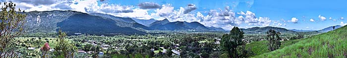
The Tenasserim Mountain Range at Ranong
Part of the Tenasserim Mountain Chain close to the coastline. Image by Asienreisender, 2012
The mountains in the inland around La Un. Image by Asienreisender, 2012
So, while I spent three month here in and around Ranong in the rain, I could have had it much sunnier just 120 kilometers east, lets say around Chumpon. But rain has also it's advantages. The botany and wildlife are rich and the temperatures are moderate. And there are unique landscapes around here, wild and fascinating. Besides, I spent already a great deal of time almost all along the eastern coast.