Trang is one of the Thai cities and province capitals in Thailand's deep south, situated at the Andaman Coast, Indian Ocean. It's Satun's northern neighbour, but a much different kind of place. Trang is one of the oldest settlements in Thailand - it dates back 2,000 years as an ancient trading port. But it was moved, due to frequent floods, in the 19th century into the inland. The old Trang was situated at the spot where Kantang is nowadays, some 20, 30 kilometers south-south-west of Trang. Kantang is still a port with a busy pier at the coast.
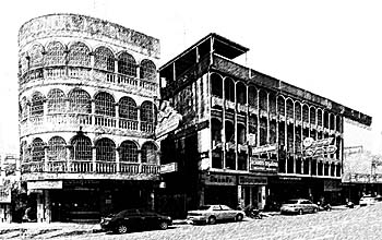
Trang City is a modern city, means coined by asphalt and concrete. There is practically little, if anything what looks pretty. Image by Asienreisender, 2012
Trang is a very lively city which is traditionally dominated by Chinese business and a Thai/Chinese population. Because of the Chinese long-term overseas trade relations, many people in Trang are more open-minded and speak generally better English than it is the case in other Thai cities; in fact it's remarkable for Thailand. It's sometimes said, that Trang is the cleanest city in Thailand. In recent years it got an award for that as well. Trang has also the recommendation to be Thailand's richest city. Remarkable is also that one get's in Trang's restaurants almost always a pot of tea, coming with the food. That's a great custom which I miss elsewhere in Thailand. By the way, it's according to what Simon de la Loubere wrote in his Depiction of Siam about the customs in old Ayutthaya.
While the city itself is Chinese dominated, the countryside around in the province is rather Muslim dominated.
Around the city in Trang Province it's the same as it is in Satun: all the tropical rainforest and jungle has been destroyed already years ago - left are only plantation monocultures in a large style, mostly rubber plantations and oil palms. I actually almost never see a rice paddy anymore, although rice cultivation was always an important part of traditional agriculture - in the past. Rubber and palm oil compete with food, and make the food prices going up.
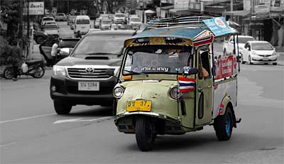
Trang's Tuk-tuks
This is the local, Trang version of the famous 'tuk tuk'. Image by Asienreisender, 2012
Almost shocking is the observation, that the traffic rate rose considerably within the last four years. While the roads around Trang, further than five kilometers around the city, where rather empty, now there is much traffic on them and it's quite a rush as well. Whithin Trang City traffic is already so much that there are traffic jams and the city authorities built a number of redlights. The enormous traffic is not only destructive, dangerous, polluting, noisy and annoying - it's unusually for most Thai places but, I am afraid, paradigmatic for the near future for many cities and towns. Thailand has a big car industry (mostly Japanese manufacturers) and is boosting car sales into the population. There must be a high rate of traffic growth every year. Seems pretty much that the financial industries blow up another credit bubble to feed that dirty growth. But it works temporarily- the verymost people want nothing more than a new, big, big car. Sometimes I hear about Thai People who sell their house and garden, renting from now on their former property from the new owner just to buy a big, new car with the gotten money.
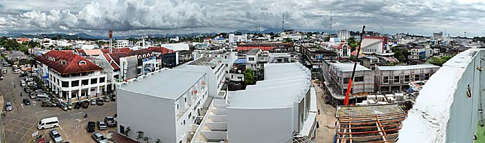
Trang Downtown
Trang City center, seen from the roof of one of the big hotels. Image by Asienreisender, 2012
2.
Shores and Beaches
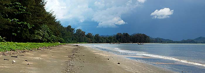
Around Trang there is a really beautiful coastline, particularly the western shores of the province. All the strech from Pak Meng to Ban Hat Yao is great, and partially national park. Pak Meng is the most popular beach of Trang; it's possible to go there on a local bus (a Songtheaw, 35 kilometers); the trouble is, that the last of these busses goes back to Trang quite early - sometimes before 4pm. Missing it means hitch-hiking back to Trang. Alternatively there are some guesthouses at Pak Meng.
Pak Meng Beach
Trang's beaches are not less attractive than those of Phuket and other places of mass tourism, but here exists only a rudimentary tourist infrastructure, if any. Image by Asienreisender, 2009
Although the beach at Pak Meng is great with all the islands one can see from here (among them Ko Lanta, the biggest of them), the single, parallel road to the beach is really drab. There are for some kilometers restaurants after restaurants, and all of them sell the same kind of seafood. It's all deep-fried and prepared as junk food. One needs to search for a time to find some decent food here.
In the past it was said that Pak Meng is built without any papers or land registrations from the authorities. The restaurant and guesthouse owners wouldn't own the land. But it's accepted by the authorities, because it's better to give the people there an opportunity to make a living than that they get criminal or elsewise deprived.
For me the nicest place at the shore is Ban Hat Yao, a small Muslim village at the southwestern corner of Trangs coastline. There is also the pier to some of the islands like Ko Libong.
Further south is Hat Samran. Basically it looks comparable to Pak Meng, but in fact it's much nicer. There is only a small, paved road at the coastline and not many restaurants. It's quieter and much more unspoiled. Big casuarina trees are growing along the beach. Therefore it's further away from Trang City and not reachable with public transport.
Trang's Beach Hat Samran
The beach at Hat Samran, seamed by casuarina trees. In the background: 'heavy weather' is approaching. Image by Asienreisender, 2012
Not far south of Hat Samran is another small Muslim village with a pier inmiddle of mangrove forest.
3.
Kantang
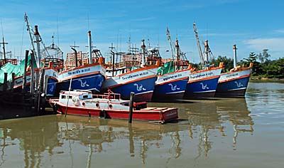
Kantang Pier
Kantang has a busy fishing fleet. Image by Asienreisender, 2012
The historical, 2,000 years old Kantang is nowadays nothing but a normal Thai town. There is no hint for the long history. The Malay people who inhabited the place first built here buildings in wood, what means they didn't last very long - a widespread phenomenon in Southeast Asia. All the many floods who happened over the centuries destroyed the old remains completely. Some evidence of the town's history is preserved in Kantang's museum. In Kantang one can also see the oldest rubber tree in Thailand. In fact, the first rubber trees in Siam/Thailand were brought by the British in the early 20th century to Trang Province.
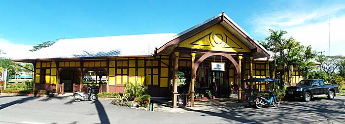
The only historical remain which is even still in use is the pretty nice, old-styled railway station. There is a split-up from the main railway connection Bangkok - Singapore to Trang, and it continues to Kantang as well.
Kantang Railway Station
Kantang's railway station, 19th century style, well preserved. Image by Asienreisender, 2012
And there is an industrial pier in Kantang, sending out goods from Trang and receiving goods from other countries - mostly China, I guess.
4.
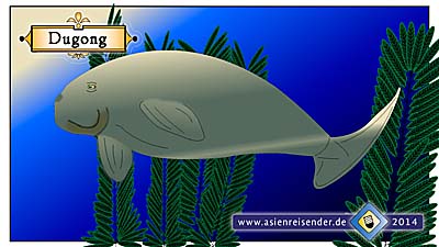
Dugongs
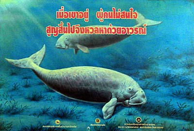
These lovely and shy mammals once appeared all along the Southeast Asian shores. They came in herds of hundred or more individuals. Nowadays, in the time of trawl-net fishing, overhunting and mass-tourism there are few of them left. Dugongs are among the endangered animals of Southeast Asia. Since some years they get some protection here in Trang Province and they are displayed frequently as a local symbol.
Dugongs
Although dugongs wouldn't make it in a beauty contest, they are really lovely animals. Image by Asienreisender, 2012
Although they normally flee people and boats there are cases in which they come close to divers to have a look for them. There are reports that dugongs played with divers for hours. Natural enemies of them are, except homo sapiens, some shark and whale species. Dugongs communicate by making a number of different, unique noises. It has been observed that dugongs in groups pushed sharks away with their snouts in shallow waters. Sometimes dugongs appear near ships or divers, trying to come in contact and starting to play with divers. That all gives the impression that they are high-developed, intelligent animals with a sophisticated social behaviour.
Dugongs need to take breath every few minutes. Therefore they have to come up to the water's surface and to take air while holding their nose out of the water, producing a certain, peculiar noise. They become around 60 years old. Pregnant femals carry their babies for thirteen months until giving birth to normally a single baby. In the average they get pregnant every seven years.
Sketch of a Dugong
Dugongs are, together with many, many other, less known animals, threatened by extinction. In the last 30-40 years about 50% of all species in our world have gone extinct, and for the next 30 years the prediction is a loss of another 50%. In Southeast Asia the extinction rate is double as high than it is worldwide, due to the rampant economic growth here.
Although the dugong's diet consists of plant food only, their size is impressing. They grow normally three meters long (up to four meters) and get a weight of 400 kilograms (up to 900 kilograms). At home along the whole Andaman Sea shores from Phang Nga down southwards, Trang's coasts are nowadays one of their last refuges. But also here their existence is threatened. Fishing, getting caught in fishing nets left carelessly by fishermen, tourism with it's polluting impact, clashes with boats and being hit by ship's propellers - these threats might doom the remaining population to extinction.
On the other hand there are improvements done by the authorities to conserve the dugongs from extinction. After all they are a tourist attraction themselves and therefore bringing money.
By the way: In former centuries there was another species of dugong's existent - Steller's seacow. It grew much bigger than the still existing species (around seven meters), but became extinct already in 1768 due to massive hunting.
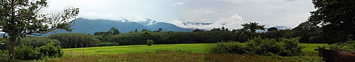
East of Trang is part of the long-streching Tenasserim Mountain Range situated, aligned in north-south direction. It's separating Trang from two eastern provinces of the Malay Peninsula. Behind the mountains lies Phattalung Province, further northeast Trang borders to Nakhon Si Tammarat Province. The mountains are notorious for having rain clouds hanging in their slopes and rain is pouring down here often and heavy. Therefore the mountains are covered by the last parts of remaining rainforest, since agriculture is not possible there. It's the last refuge for animals and plants, though a great deal of animals is extinct around for they could not escape the environmental destruction of the transformation to plantation monocultures. Also in the 'untouched' looking parts of the mountainous forests there is hunting going on and the biggest, most expensive trees are cut out since long. A big tree brings some thousand dollars - that dooms them to a short remaining live expectation.
The Tenasserim Mountains at Trang
The mountains east of Trang - always cloudy. The Tenasserim Mountain Chain divides the Malay Peninsula in two climatic regions. Image by Asienreisender, 2012
There are many waterfalls in the mountain slopes, and not many people go there. Nevertheless, Thai People love waterfalls - probably they give them mystical implications. There are some pools near the waterfalls in the rivers where swimming is possible. Some few of the places are very popular by Thai People, particularly on holidays some crowd is having a nice afternoon there. The most other places, particularly when a bit away from paved roads, are very lonesome and chances are good not to meet anybody there.
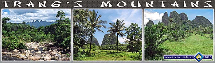
Limestone Mountains
Trang's limestone mountains are often shaped in bizarre forms. There are many holes and caves in them who give animals a refuge. Since the steep slopes are impassable and barely to reach for loggers, the last untouched tropical vegetation survives yet here. Many islands along Trang's coasts are coined by similar shapes. Images and photocomposition by Asienreisender, 2009, 2015
6.
Thung Khai -
Peninsular Botanic Garden
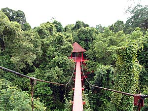
Canopy Walkway
Tropical rainforest seen from out of the tree tops. Image by Asienreisender, 2012
Some ten kilometers south of Trang, on highway 404 direction to Satun, there is on the left side of the road the 'Peninsular Botanic Garden' - also called 'Thung Khai'. It's a larger patch (4,016 km2) of tropical rainforest not changed into plantation monoculture. It gives an impressing insight into how the nature has been here before the massive industrial impact. The botanic garden, or better nature park, is a great place to do some short trekking. It's main attraction is the canopy walkway, up to 18 meters high and some 100 meters long. Here one can see the rainforest's tree tops. There is a comparable canopy walkway in Penangs National Park, but the one here in Trang looks better, is larger and no entrance is charged. It also looks brandnew. At the end of the canopy walkway a small, paved way leads into the jungle and into a swamp area one couldn't enter under natural conditions. Here one can see how impassable swamps and parts of the tropical rainforests are. It's a perfect insight into a lowland jungle, in contrast to the mountainous rainforest described above. A lot of animals are living there, among them, it's announced on a poster, even slow loris.