Uttaradit
Uttaradit is with around 34,000 inhabitants a not too small city at the northern edge of the central plain of Thailand, bordering the northern mountains. It's situated at the banks of the Nan River. The surrounding landscapes are mostly river plains, what makes the fertile area productive in rice and fruit agriculture.
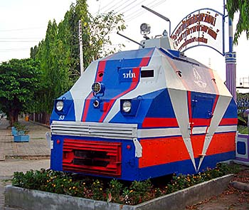
An armored locomotive, placed inmiddle of Uttaradit. Image by Asienreisender, 4/2011
In the past the legendary teak forests of north Thailand bordered Uttaradit. The name means 'northern harbor' for it was a port for incoming ships on the Nan River with their heavy teak loads and other merchandises from the north. The predatory exploitation of the northern teak forests started in the 1860s by British logging companies who came over the border from Burma (then part of British India). The large teak forests were all destroyed then until 1980.
Remarkable is the large Sirikit Reservoir about 50km east of town. It was opened in 1973 and dams the Nam River. There is a number of national parks around. In the natural park Nam Pat stands the allegedly largest teak tree in the world.
A Short History of Uttaradit
The place's history goes back to prehistory; findings of bronze knifes and drums give evidence from early inhabitants along the banks of the Nan River. From the 11th century on Tai people from the north immigrated into the region and settled down as rice farmers. The area was then for a time part of the kingdom of Lanna.
In the coming centuries the area was embattled between the Siamese and the ever and ever again intruding Burmese armies.
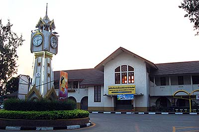
Uttaradit lies along the northern railway line from Bangkok to Chiang Mai. The railway station has been designed and supervised in the years 1906-12 by the architect Karl Döring, of who is also the station in Phitsanulok. Image by Asienreisender, 4/2011
After the downfall of Ayutthaya, Uttaradit became part of an independent movement, which was lead by a charismatic monk named Phra Fang. That is a particularly interesting part of history, because here a kind of republic was established under the initiative of common Thai People. This movement is not particularly valued in the official Thai historiography, in which everything is based on kings, kings, kings and, here and there, other members of the aristocracy. Common people only appear as the willing, childlike subjects of the semi-divine rulers. The 'Monks Republik of Fang' also gained controll over Phitsanulok in 1770, but was then militarily defeated by king Taksin and incorporated into the kingdom of Thonburi. The monks were executed.
There were some struggles between the Thai and the Burmese here in the late 18th century. The local governor gained some fame in driving a Burmese attempt to conquest the place back.
Why Here?
I personally had a stopover in Uttaradit when I tried to hike and hitch-hike along the Laotian border from Loei to Nan. At one point in the countryside, I couldn't get a lift, and it was said the road was not in use. There was no alternative for me but to spend a night there and to go back next day to make the detour to Nan via Uttaradit. There, I rent a motorbike and inspected the missing road link. On my map, it appeared as a fine road like before and behind, but in fact this road through the forested mountains wasn't built yet; it was only in planning. I drove then over 30km or more through the mountainous forests, following a very rough track. The only hint for the prospected road were a few kilometer stones who were already set to mark the coming road.